
Fearn Airfield


Airfield (20th Century)
Site Name Fearn Airfield
Classification Airfield (20th Century)
Alternative Name(s) Hms Owl; Loans Of Rarichie; Balintore Airfield
Canmore ID 91604
Site Number NH87NW 21
NGR NH 8437 7597
NGR Description Centred NH 8437 7597
Datum OSGB36 - NGR
Permalink http://canmore.org.uk/site/91604


- Council Highland
- Parish Fearn
- Former Region Highland
- Former District Ross And Cromarty
- Former County Ross And Cromarty
Airfield (disused) [NAT]
OS (GIS) MasterMap, May 2010.
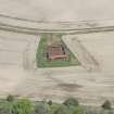
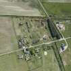
NH87NW 21.01 NH 84794 76158 Control Tower
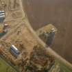
NH87NW 21.02 Centred NH 8499 7610 Buildings; Nissen Huts; Air-raid Shelters
NH87NW 21.03 Centred NH 8496 7549 Buildings; Hangars; Nissen Huts
NH87NW 21.04 Centred NH 8465 7657 Hangars; Nissen Huts; Buildings
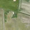
NH87NW 21.05 Centred NH 8362 7646 Bomb Store
NH87NW 21.06 NH 8489 7614 Control Tower
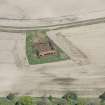
NH87NW 21.07 Centred NH 8360 7557 Hangars; Buildings
NH87NW 21.08 Centred NH 8405 7518 Hangars; Buildings
NH87NW 21.09 NH 8495 7560 Building
NH87NW 21.10 NH 8523 7630 Operations Block
Location formerly entered as NH 843 759.
For associated accommodation area (centred NH 8573 7705) at Loans of Tullich, see NH87NE 34.00.
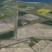
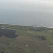
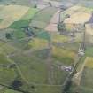
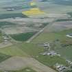
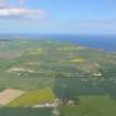
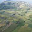
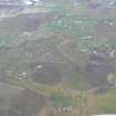
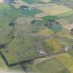
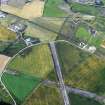
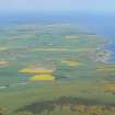
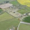
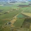
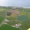
Fearn airfield is situated in a low lying area of land to the S of Hill of Fearn village and W of the B9166 road to Balintore.
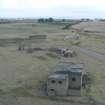
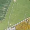
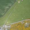
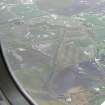
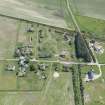
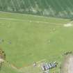
The three runways are all extant, the main N-S one still being used for 'touch and go' runs by propellor driven aircraft on training flights. All the dispersal areas can still be traced, some still retaining their hangars (all of the Main or Mainhill type), though many of the blast banked dispersal pens have been removed by the farmers.
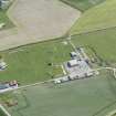
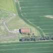
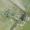
In the technical area, to the E of the main control tower, many of the surviving buildings are still roofed and in use as offices, motor repair shops or for farming purposes. Most notable are three large nissen huts joined together forming what was the torpedo store. As this building is not shown on the RAF plan (RAF archives 77/1/470) it can be assumed that it was built post 1942 after the Royal Navy had taken over. The Luftwaffe photograph of 1941 (RCAHMS C47611) also shows the airfield before alterations by the Royal Navy. The pre-navy period watch tower survives to the rear of the large three/four storey tower (NH87NW 21.01), though it only stands one storey high. Many of the extant buildings in this area are associated with the subsequent take over by the Navy and are therefore post 1942 as few are shown on the PRO 1941 plans.
The four storey tower (NH87NW 21.01) is of a type found on RN stations, it is thought that this may be the only one of this type to survive in Scotland. The interior has been heavily vandalised, many of the intenal divisions having holes knocked through. The interior has also suffered at the hands of the grafitti artists so that any internal painted notices have long since disappeared. The upper storey is inaccessible as the stair to it has been removed.
Fearn Airfield is visible on vertical air photographs (RAF CPE/Scot/UK/223, 3151-3, flown 1947) in its complete state and vertical phtographs taken during the war (NLA 57.540 5101-5, flown 1943) show the dispersal pens and some of the hangars.
Visited by RCAHMS (DE, PM) January and May 1997
NH 85 76 A photographic survey and limited recording was carried out with ASH Consulting Group of all remaining structures belonging to Fearn Airfield.
Report held by the NMRS and Highland SMR.
Sponsor: Highland Council.
J Kendrick and J Wordsworth 1999
Much of this airfield is extant, including the runways, control tower and hangars.
J Guy 2000; NMRS MS 810/10, Vol.1, 121, Vol.3, 60.

