
Ackergill Links


Burnt Mound (Prehistoric)(Possible), Cist (Period Unassigned)(Possible)
Site Name Ackergill Links
Classification Burnt Mound (Prehistoric)(Possible), Cist (Period Unassigned)(Possible)
Alternative Name(s) Wic 122; Reiss Links
Canmore ID 9135
Site Number ND35NW 9
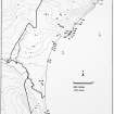
NGR ND 3403 5674
Datum OSGB36 - NGR
Permalink http://canmore.org.uk/site/9135


- Council Highland
- Parish Wick
- Former Region Highland
- Former District Caithness
- Former County Caithness
ND35NW 9 3403 5674
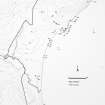
On Reiss Links there is a cairn of earth and stones covered over with turf. The E side has been cut away revealing down to the undisturbed sand two flagstones placed end to end; the N slab measures 3ft 9ins by 1ft 11ins. The dug-away side of the cairn measured 19ft in length along the face from N to S, and the breadth is 9ft. There is a shallow ditch or trench around it. On the surface at the foot of the slabs are numerous fragments of red clay burnt hard. On excavation, four cist-like graves were discovered; puddled red clay, in part hard from the action of fire, and pieces of bone were found but no pottery. The dampness of the cairn, in which rounded granite stones were disintegrating, would account for the disappearance of the skeleton. Some charcaol was found and much blackened earth, but nothing else apart from periwinkles.
Information contained in Mss notes of L Duff-Dunbar dated 26 May 1933, now held by R B Gourlay, Highland Region Archaeologist.
ND 3405 5670. An oval mound, 36 by 24 m, with large stones and two upright stones at the SE end.
C E Batey 1981.
The 'cairn' examined by Duff-Dunbar and the mound described and planned by Batey are one and the same, located at ND 3403 5674 in a valley between consolidated dunes, now within a golf course; a tee position intrudes on the E side. The plan by Batey is generally correct though the margins are indistinct; the mound is turf-covered and apparently composed of earth and sand, though some rubble stones show on the S side. The slabs, laid end-to-end, protrude 0.25m from the top of the mound and the upright immediately S of these stones are 0.35 and 0.4m high, the latter being slightly inclined.
Duff-Dunbar's notes do not specify at what level the four cist-like graves were found, nor whether the pieces of bone were human. The structure exposed on the top of the mound, whatever its function, appears to be intrusive. The mound itself is amorphous and cannot be categorised as sepulchral; it may be a low, natural dune into which graves have been inserted. Numerous long cists have been discovered in the dunes between Keiss (ND 34 60) and Ackergill (ND 34 55), including one where a pair of headstones were found (ND35SW 5) and it seems that this structure is a cist with or without a cairn. However, the existence of burnt red clay, charcoal and blackened earth may suggest a roasting hearth or a burnt mound; there is a stream immediately to the N.
Surveyed at 1:10,000.
Visitd by OS (N K B), 2 September 1982.
Field Visit (2 September 1982)
The 'cairn' examined by Duff-Dunbar and the mound described and planned by Batey are one and the same, located at ND 3403 5674 in a valley between consolidated dunes, now within a golf course; a tee position intrudes on the E side. The plan by Batey is generally correct though the margins are indistinct; the mound is turf-covered and apparently composed of earth and sand, though some rubble stones show on the S side. The slabs, laid end-to-end, protrude 0.25m from the top of the mound and the upright immediately S of these stones are 0.35 and 0.4m high, the latter being slightly inclined.
Duff-Dunbar's notes do not specify at what level the four cist-like graves were found, nor whether the pieces of bone were human. The structure exposed on the top of the mound, whatever its function, appears to be intrusive. The mound itself is amorphous and cannot be categorised as sepulchral; it may be a low, natural dune into which graves have been inserted. Numerous long cists have been discovered in the dunes between Keiss (ND 34 60) and Ackergill (ND 34 55), including one where a pair of headstones were found (ND35SW 5) and it seems that this structure is a cist with or without a cairn. However, the existence of burnt red clay, charcoal and blackened earth may suggest a roasting hearth or a burnt mound; there is a stream immediately to the N.
Surveyed at 1:10,000.
Visitd by OS (N K B) 2 September 1982.

