
Edinburgh, North Bridge


Road Bridge (19th Century)
Site Name Edinburgh, North Bridge
Classification Road Bridge (19th Century)
Alternative Name(s) North Bridge Street; The Market Stairs; North Bridge Street; Nor' Loch; Waverley Station; War Memorial, King's Own Scottish Borderers Memorial
Canmore ID 90306
Site Number NT27SE 1278
NGR NT 25888 73842
Datum OSGB36 - NGR
Permalink http://canmore.org.uk/site/90306


- Council Edinburgh, City Of
- Parish Edinburgh (Edinburgh, City Of)
- Former Region Lothian
- Former District City Of Edinburgh
- Former County Midlothian
NT27SE 1278 25888 73842
See also under individual buildings.
See also:
NT27SE 5281 NT 25875 73764 Scotsman Steps [stairway]
NT27SE 5660 NT 25904 73826 South African War Memorial (King's Own Scottish Borderers)
For South Bridge (continuation to S), see NT27SE 1279.
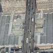
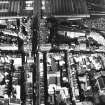
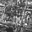
North Bridge [NAT] (at NT 2589 7382)
OS (GIS) AIB, May 2006.
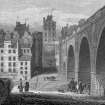
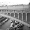
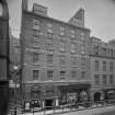
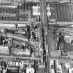
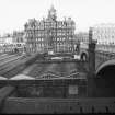
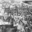
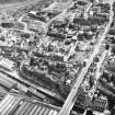
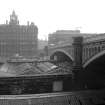
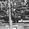
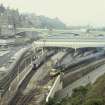
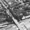
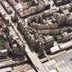
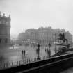
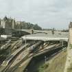
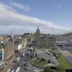
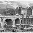
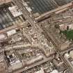
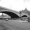
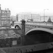
(Location cited as NT 259 739). North Bridge, built 1896-7, engineers Blyth and Westland. A 3-span bridge, with steel segmental arches on masonry piers. Spandrels of the outer ribs are faced with cast-iron panels decorated with swags and arcades.
J R Hume 1976.
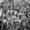
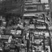
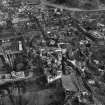
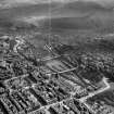
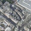
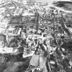
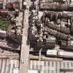
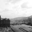
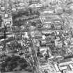
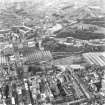
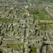
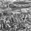
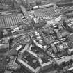
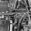
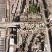
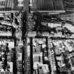
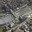
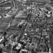
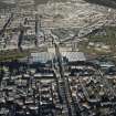
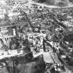
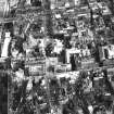
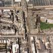
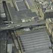
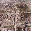
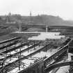
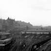
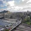
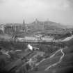
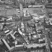
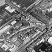
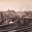
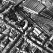
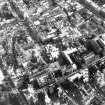
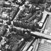
This bridge spans the former location of the (drained) Nor' Loch and the present Waverley Station (NT27SE 221.00) between the E end of Princes Street (to the N) and near the E end of the High Street (to the S).
The location assigned to this record identifies the approximate midpoint of the structure. The avaiable map evidence suggests that it extends from NT c. 25848 73993 to NT c. 25934 73663.
Information from RCAHMS (RJCM), 15 May 2006.
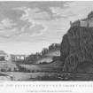
ARCHITECT: William Mylne 1765
James Craig -design for a Bridge 1763
David Henderson -design 1770
R & R Dickson 1817 (probably Crichton's design) -range of shops
NMRS REFERENCE:
Historical File:
2 pages of text giving details of articles in Scots Magazine between 1763 and 1773 -filed under 'OLD NORTH BRIDGE';
6 pages of text giving details of development of North Bridge and its effects on the surrounding areas -filed under 'NORTH BRIDGE STREET NEW BUILDINGS';
24 pages of text giving details of development of North Bridge and its effects on the surrounding areas -filed under 'NORTH BRIDGE (NEW) AND STREET';
10 pages of text detailing the development of the area around Cockburn Street and North Bridge -filed under 'COCKBURN STREET'
NMRS LIBRARY
Scots Magazine 1763 p.408 -engraving of a plan and elevation intended to be built over the North Loch -James Craig del.
'Redecoration, repair and lighting of the North Bridge, Edinburgh', EDINBURGH ARCHITECTURAL ASSOCIATION REVIEW, 1990, 39-41.
A small impression of the columnar quadrant appears in the view of the Theatre Royal given in Grant's Old and New Edinburgh, Vol.1, page 349.
Ainslie's Map of 1804 shows St Ann's Street and the buildings existing at that time -in Cowan's Early Maps of Edinburgh 1544-1852.
REFERENCE: HUNTLY HOUSE MUSEUM
Suggested improvement of the North Bridge by James Gowans 1870 -perspective and elevation
REFERENCE: EDINBURGH PUBLIC LIBRARY
J G Tunny's Photographs of Edinburgh (1855) No 3.
In the staircase of the extension of the Public Library at No 3 George IV Bridge hangs an engraving of North Bridge Street by S.D.Swarbreck, dated 1837. This view, from the North, shows prominently these "New Buildings".
REFERENCE: SCOTTISH RECORD OFFICE
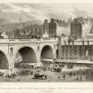
Collapse of part of North Bridge during its erection. Appellant's case (William Mylne, architect in Edinburgh, Robert Mylne, Architect in London and others) against Magistrates and Council of Edinburgh.
1770 GD1/51/34
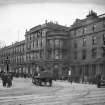
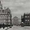
North Bridge looking towards Register House. Shows cable-hauled tramcars. Glass plate and print. Held in West Register House.
N.D. GD 1/860
Plans for the Nor' Loch Bridge. Uncertainty over merits of bridge or aquaduct plan. John Baxter lays down conditions for his services. Opinion sought from Robert Adam, George Clerk, Robert Mylne, Jo Smeaton and Chalmers. Letters.
1765 GD 18/5832
REFERENCE: PLANS: CITY ARCHITECT'S PLAN STORE
Drawer No 1000 contains:
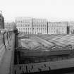
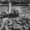
Photograph of the back of the buildings on the West side of the Old Shakespear Square, (which see under) prior to the building of the 'North Bridge Station Hotel'. Shows Waterloo Place and the Calton Hill monuments, and in the foreground the roof of the Fruit and Vegetable Markets. (Photostat copy held in NMRS).
Drawer No 38 contains:
Plan showing the alignments etc of the piers and the dimensions and elevation showing the Bridge as it stood on 10/11 October 1769 and as it ought to have been in terms of the contract, ie some 6'10 3/4" lower than the contract, and giving the heights at each pier -both drawings to the large scale of 1/4 mile to the foot, and both signed by john Laurie and Da. Henderson.
Also a small lithographed drawing showing "Design for proposed widening of North Bridge" dated 1873 (Photostat copy held in NMRS).
Drawer No 75 contains:
Plan and elevation showing "Alteration on North Bridge" under the heading of City Imprivements and dated from 50 George Street, 1874. These show the opening out and the enrichment of two of the arches of the South Abutment at the junction of Jeffrey Street and Market Street. The elevation shows the widened bridge. The plan is stamped by Lessels & Taylor, Architects. (Photostat copy held in NMRS).
On 20th October 1875 the bridge was re-opened after having been widened and its level raised 18" (Edinburgh in the 19th Century, 1901, edited by W M Gilbert).
A bronze tablet giving a presentment of the Old Bridge has been affixed to one of the main piers on each side of the New Bridge (see under) -the South pier on the West side, the North pier on the East. These tablets bear the legend "founded 1763, widened 1876, taken down 1896-97".
Drawer No 14 contains:
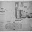
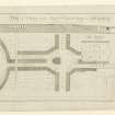
No 26-a copy of a block plan, to the approximate scale of 1/500 showing the original buildings on St Ann's Street facing East across that street on the ramp of the Bridge, and running from Princes Street South to the East end of Canal Street. Superimposed and outlined in red are the lines of the New Buildings brought forward and occupying the greater width of St Ann's Street, while the remainder of the width of the Street -about 12 feet, is thrown into the width of the Bridge, while below the level of the Bridge at this part is to be cellarage. A similar range of buildings is proposed for the East side of the Bridge, but this was not carried out, the site there being later occupied by the General Post Office (which see under). To the West is indicated a "New Road leading from Princes Street to Canal Street in lieu of St Ann's Street" which was to be absorbed by the operations: this was virtually the beginning of the Little Mound which eventually was replaced by the Waverley Bridge.
A large cloth tracing headed "North Bridge Improvement" of a plan showiing the new frontage lines in Princes Street and North Bridge Street of the Hotel and Offices proposed to be erected by the North British Railway Company between the Waverley steps and North Bridge Street, Edinburgh. It is docketted as the plan referred to in the agreement between the Magistrates and Town Council and the North British Railway Company regarding the re-building of the North Bridge, signed of date 25 and 29 days of May 1894 and therein called "Sketch marked B". Signatures appended are those J.A.Russell, Lord Provost; Wm Skinner, Town Clerk; and of two Directors and the Secretary of the Railway Company. The lines of the front walls on Princes Street and North Bridge Street of the proposed Hotel are shown in red, adn the building line on North Bridge Street almost coincides with that of the buildings now to be removed. The width from that line to the street balustrade of the New Post Office is figured as 75'2" at the South angle of the Post Office and 72'9" at the North angle.
Drawing No 39a, North British Railway Map of proposed alterations to the Waverley Station and its approaches, to scale of 100 feet to 1 inch, dated 1865, by Charles Jopp, Engineer.
Drawer No 31 contains:
a) Elevation and plan of front walling, to scale of 3/4 inch to 10 feet, of New Buildings on West side of North part of North Bridge Street, three storeys high with end pavilions of four storeys, by Richard and Robert Dickson, 10 James Street, Edinburgh. Docketted 5 Nov.1816 as referred to in Minute of a Committee of Council of this date and signed by A Cunningham. The four storey pavilions have flaps evidently showing revised designs, and dicketted also same date as referred to in Minute.
b) Elevation of the East front of the St Ann's Street building, dated 9th September 1817. Similar to last, showing the columnar quadrant next the building at North end, which si indicated as Mackay's Hotel.
c) Engraved print by Lizars of the plan and elevation of the buildings to be erected in St Ann's Street. No date, but similar to a) and b) above.
d) Elevation of the Buildings to be erected to front the North Bridge, but altered from the original design, being a storey less in height. By R & R Dickson, October 20, 1817. Scale 3/4 inch to 10 feet. Evidently not adopted.
e) Two drawings, one a two-storey design and the other a three-storey, neither adopted, by William Burn, Architect, 76 George Street and dated Decr. 31 1817.
Drawer No 100 contains:
a) Paper tracing, to scale of half-inch to ten feet, of a Block Plan of the North British Railway Waverley Station Hotel, showing in red lines the building lines of the buildings to be removed. From 136 George Street, the office of George Beattie & Son. Dated has been torn away, but may be about 1894.
b) A rough sketch showing "Mr Hamilton Beattie's selected design for the new North British Railway Hotel in its correcy proportions and position in the landscape". No date.
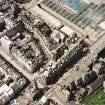
c) A photograph looking from the West over the roof of the Waverley Market towards the rear of the "New Buildings" of 1816-18. On the back has been pasted a paper representing the block of the proposed Station Hotel in its relative position, and this can be seen when the photograph is held against the light.
III -Folder giving plans and sections exhibited in connection with the North British Railway Act of 1891, to which reference has already been made. The folder includes a main plan showing the environs of the North Bridge and Street, and shows the General Post Office as existing. Included in lands to be acquired is the site of the "New Buildings" on the West side of the Northern part of North Bridge Street, and where, at the Northern end, stands now (1949) the Station Hotel. The plan also shows the Waverley Market, the site of which is also shown as included in the lands to be acquired, but this was excepted from the scheme.
IV -Folder of plans and sections showing the North Bridge Improvement, and Book of Reference to the plans and to the Lands and Propoerties to be acquired, as deposited in duplicate and exhibited in connection with the Bill in Parliament, Session 1894. The Book of Reference contains an excerpt from the Notice of Application to Parliament published in the "Edinburgh Gazette" of November 21 1893.
V -Cloth tracing of plan showing relation of Old Bridge to the piers of the New, being copy of plan for Deed of Conveyance as sent to Town Clerk by Public Works Office. Scale 30 feet to 1 inch. No date, but probably about 1893 or 1894.
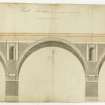
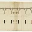
VI -A series of sketch drawings, to various scales, of the architectural features of the North Bridge, from the Public Works Office (Robert Morham, City Architect) 1895-97.
VII -Sketch drawings indicating the effect of sculptural groups mounted on the main piers of the Bridge, including -a)Cloth tracing showing central span to scale of 5/8 inch to 10 feet and detail of pier to scale of four feet to 1 inch; b)Perspective drawing of the centre span with the piers surmounted by such groups-Public Works Office, 13 January 1904.
VIII -Large photograph of North Bridge viewed from the West, on which groups of statuary on the piers have been suggested in pencil. Probably of date 1904.
IX -Conditions of Competition for rebuilding the South part of North Bridge, issued March 3 1896, together with two lithographed sheets to sections.
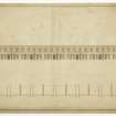
X -Lithographed plan issued by the Public Works Office and dated 16 April 1895, showing the existing buildings on each side of the South part of the 50 feet wide North Bridge Street including Milne Square on the West side, and Halkerston's Wynd and Kinloch's Close on the East. It shows the building sites where at that particular date they were being acquired, i.e. on the South towards Market Street and coloured red. Scale about 2 1/4 inches to 100 feet (Photostat copy held in NMRS).
XI -Two lithographed plans, dated February 15 1898, prepared for sale by Public Roup of the ground. On one the whole area on the West side of the Street is designated Lot 1 and the whole area on the East side Lot 2; and on the other Lot 1 is divided into two, Primo and Secundo, and Lot 2 into three, Primo the North part, Secundo the middle and Tertio the South part, next the High Street (Photostat copy held in NMRS).
XII -Plan dated 13th January 1898, by the Public Works Office for Councillor Cameron, dividing the areas into small lots, submitted at Council meeting on January 17 of that year. Lots are differently coloured. Scale 5/8 inch to 10 feet; and two lithographed plans reduced to scale of about 3/8 inch to 10 feet, one showing as a comparison, the plan of block on the West side of the street according to the competition, and the plan as proposed by Councillor Cameron; with a flap showing amendment by the valuators; while the other shows the proposed plan for the block on the East side of the street. Both lithographed plans are docketted as prepared by R.M.Cameron, Architect, 1/10/97.
XIII -Cloth copy of plan, scale about 2 1/4 inches to 10 feet, engrossed for feu charter in respect of Lot 2 Tertio as "This is the Plan referred to in the Disposition by the Lord Provost Magistrates and Council of the City of Edinburgh in favour of the Commercial Bank of Scotland. Signed May 13 1898, W Mitchell Thomson L.P. and Thomas Hunter, T.C.
XIV -Cloth copy of similar plan, to same scale as above, in respect of Lot 2 Secundo and Primo, engrossed as "This is the PLan referred to in the foregoing Disposition by the Lord Provost Magistrates and Council of the City of Edinburgh in favour of John White, Builder, Edinburgh, May 9 1899. Signed W Mitchell Thomson, L.P. and Thomas Hunter, T.C.
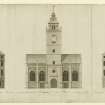
XV -Elevation as submitted to Town Council for approval of buildings at corner of High Street and North Bridge Street, to scale of 5/8 inch to 10 feet, coloured, being the building on the South part of the area acquired by the Commercial Bank. Signed by Sydney Mitchell & Wilson, Architects, 13 Young Street, Edinburgh, June 1898 and stamped "Town Clerk's Office, Edinburgh".
XVI -Elevation submitted to Town Council of proposed building on North Bridge Street, to scale of 5/8 inch to 10 feet, being the building on the North part of the area acquired by the Commercial Bank. Signed by W.Hamilton Beattie, Architect, 136 George Street, Edinburgh, July 1898 and stamped "Town Clerk's Office, Edinburgh". Coloured.
XVII -North and West Elevations of Building on the East side of the Northern part of the rebuilding, coloured, to scale of 5//8 inch to 10 feet. Docketted "Edinburgh 22nd Nov 1898. This is the Elevation Plan referred to in my offer of this date" and signed by John White. As seems apparent from other drawings in the custody of the City Architect, these elevations were issued from 136 George Street, the address of W.Hamilton Beattie, Architect.
XVIII -Perspective view, in pencil, from the North West, above Bridge level, of the building of John White, on the East side of the Bridge. Probably by W.Hamilton Beattie.
XIX -a)Working drawings of shop fronts on the East side of North Bridge Street and denominated "Edinburgh Bon Marche Limited"; b)Watercolour drawing of these shop fronts, marked in pencil as "Amended plan as recommended for approval". Date of these drawings seems to be 1902.
XX -Elevation of "Scotsman" Buildings on the West side of North Bridge Street, in mount, tinted, scale 5/8 inch to 10 feet. Probably that submitted to Town Council for approval. No name, but doubtless by Dunn & Findlay, Architects, 35 Frederick Street, Edinburgh, the architects of the buildings.
XXI -Mounted tracing of the North Elevation of the "Scotsman" buildings, scale 8 feet to 1 inch. Address is given as 35 Frederick Street (Dunn & Findlay).
Drawer No 28 contains:
Two sheets paper tracings showing 6 floor plans and entrance on Ground Floor of the Union Hotel in the National Bank of Scotland building at corner of High and Cockburn Streets. Scale one and a half inches to tem feet. Dated Public Works Office-and probably surveyed by that Office- February 1919. It is this building, the stonework of which has much decayed in places, which suggested the style to be adopted for the rebuilding of the Southern part of North Bridge Street.
REFERENCE: BUILDING NEWS
In the "Building News" of October 16 1896, is given a description of the accepted design of the North Bridge Street development, from the report submitted with their drawings by J.N.Scott & J.A.Williamson, and their drawings are illustrated by plates showing Ground Floor pLan, Bridge Street level, West side, with an Elevation to North Bridge Street (a note states the Elevation of the East side is similar); North Elevation with block transverse section through the Bridge; and Perspective drawing of view from the North West, sculptured groups being suggested surmounting the main piers of the Bridge.
The same journal of October 23, following illustrates the design, awarded the second premium, of Gibson & Russell, London, by a plate giving a virile perspective view from the North East, with the Bridge in the foreground; and in its number for November 6, it illustrates the design of Lanchester, Stewart and Rickards, London, awarded third permit by a tinted perspective view from a point to the North above the level of the Bridge.
REFERENCE:
Plans:
NMRS Academy Architecture
Scott & Williamson, 4a St Andrew Square, Edinburgh
North Bridge Street, Reconstruction Ed, First premiated design
1896 Vol 2 p. 97
NMRS LIBRARY:
Historical File: 'North Bridge (new) and street'.
Edinburgh, North Bridge Street.
Sources: Dean of Guild. Bundle, 1813. January-June 20.5.1813
Pet. Andrew Melray/Melroy, Jeweller.
No.35 North Bridge Street.
Alterations to shop front.
Elevation encl. showing two floors plan.
Signed: CR or RC
Edinburgh, North Bridge Street.
Sources:Dean of Guild. 31.3.1814
Pet. John Forrest, merchant.
North Bridge Street East side.
Elevation, unsigned, for alterations to shop front.
Edinburgh, North Bridge Street.
Sources: Dean of Guild. Bundle 1810. 9.8.1810
Pet. Richard Ballatyne, merchant.
32 North Bridge Street.
Minor alterations - to erect a wooden front like that of the shop next door.
Plan and elevation of two shops encl. unsigned.
(Undated) information in NMRS.
Project (1997)
The Public Monuments and Sculpture Association (http://www.pmsa.org.uk/) set up a National Recording Project in 1997 with the aim of making a survey of public monuments and sculpture in Britain ranging from medieval monuments to the most contemporary works. Information from the Edinburgh project was added to the RCAHMS database in October 2010 and again in 2012.
The PMSA (Public Monuments and Sculpture Association) Edinburgh Sculpture Project has been supported by Eastern Photocolour, Edinburgh College of Art, the Edinburgh World Heritage Trust, Historic Scotland, the Hope Scott Trust, The Old Edinburgh Club, the Pilgrim Trust, the RCAHMS, and the Scottish Archive Network.
Project (2007)
This project was undertaken to input site information listed in 'Civil engineering heritage: Scotland - Lowlands and Borders' by R Paxton and J Shipway, 2007.
Publication Account (2007)
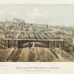
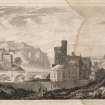
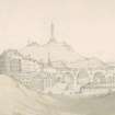
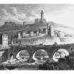
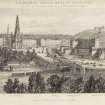
This bridge, also originally development-led, linked the Old and New Towns of Edinburgh over the Nor’ Loch valley, partially drained by ca.1763, over ground now occupied by Waverley Station. The foundation stone for the first bridge was laid in October 1763 by Lord Provost George Drummond, but no further work was done until after a design competition in 1765. This was won by David Henderson, but his design was not implemented and the bridge as built was designed by William Mylne. It had three main masonry arch spans of 72 ft about 68 ft high adjoined on each side by a small abutment arch, three tall rubble vaults, and tall abutments reducing in height beyond. The contract was signed in August 1765 for the sum of £10 140. The bridge was opened to pedestrians in early 1769, but soon after, a vault and side wall at the south side collapsed resulting in five deaths. This seems to have arisen mainly from an error in levels which had led to the vault arches being too low and requiring a great depth of infill to reach road level, the pressure from which caused the collapse. Smeaton was called in to remedy matters and on his advice substantial internal cavitation was incorporated into the superstructure to lighten it. The bridge was eventually completed in 1772 at a cost of about £17 354.
R Paxton and S Shipway 2007
Reproduced from 'Civil Engineering heritage: Scotland - Lowlands and Borders' with kind permission of Thomas Telford Publishers.
Field Visit (18 March 2009)
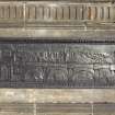
Four bronze plaques on North Bridge. Two have two Edinburgh arms and the above inscription. Two depict in low relief the old North Bridge with the cityscape to the castle behind it, one on the east side of the bridge, one on the west. The reliefs are edged with egg and dart moulding and flowers within a square at each corner.
The plaques are located one third and two-thirds of the way along the bridge. Each inscription plaque faces a plaque decorated with the cityscape.
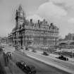
Robert Morham was the designer of the bridge elevations; Cunningham, Blyth & Westland were the engineers, and Sir William Arrol & Co. the contractors.
Inspected By : D. King
Inscriptions : On inscription plaques, one on east side, one on west side (raised letters):
NORTH BRIDGE / FOUNDATION STONE LAID 25TH MAY 1896 / AND / BRIDGE OPENED 15TH SEPTR 1897 / BY / THE RT. HON. SIR ANDREW MCDONALD LORD PROVOST. / BLYTH & WESTLAND M.M.INST. C.E. ENGINEERS. / SIR WM ARROL & COY, LTD. CONTRACTORS. / THOMAS HUNTER W.S. / TOWN CLERK.
On ribbon below coats of arms on inscription plaques (incised letters): NISI DOMINUS FRUSTRA
On plaques depicting cityscape, one on east side, one on west side (raised letters across relief):
OLD NORTH BRIDGE / FOUNDED 1763 WIDENED 1876 TAKEN DOWN 1896-97
Signatures : None
Design period : 1894-1897 (Building of bridge)
Unveiling details : 15th September 1897 by the Lord Provost, the Rt. Hon. Sir Andrew McDonald
Information from Public Monuments and Sculpture Association (PMSA Work Ref : EDIN1314)

