
Broughwhin Loch


Cairn (Period Unassigned), Stone Row (Neolithic) - (Bronze Age)
Site Name Broughwhin Loch
Classification Cairn (Period Unassigned), Stone Row (Neolithic) - (Bronze Age)
Canmore ID 9019
Site Number ND34SW 20
NGR ND 31307 41222
NGR Description ND 31307 41222 and ND 31295 41194
Datum OSGB36 - NGR
Permalink http://canmore.org.uk/site/9019


- Council Highland
- Parish Wick
- Former Region Highland
- Former District Caithness
- Former County Caithness
ND34SW 20 31307 41222 & 31295 41194
(ND 3130 4122) Cairn (NR) & site of Stone Rows (NR)
(Undated) annotation on OS map.
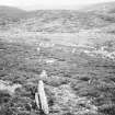
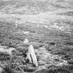
The remains of a cairn, much dilapidated and overgrown with heather, lie on the top of a low ridge, some 80 yds east of the north end of Broughwhin Loch.
An unascertainable number of stone rows have run from it towards the south, but only two or three stones remain upright. Others lie displaced. The stones have stood facing across the rows.
RCAHMS 1911.
The indefinite remains of a cairn, c. 11.0m in diameter and 0.5m high, containing in its centre the possible remains of a cist of which only one slab remains. There is no trace of the stone rows.
Resurveyed at 1/2500.
Visited by OS (N K B) 27 April 1967.
The remains of this cairn are situated on the summit of a heather-grown hillock some 50m to the E of the dam at Broughwhin (ND34SW 59). It measures 9.2m from N to S by 8m transversely and up to 0.7m in height, and contains a central cist aligned E and W. Only one slab of the cist is still visible, forming the S side of a hollow measuring 1.3m in length by 0.8m in breadth and 0.4m in depth.
Very little is now visible of the stone rows that lay on the slope below the cairn to the SSW. The slope is covered in knee-deep heather and only two stones of one row were recorded on the date of visit. These lie towards the foot of the slope immediately above wet ground, and are set 2.2m apart. The larger (N) is 0.4m long by 0.2m thick and stands 0.35m high. A third stone has been set up on edge off the line of the row to the SW.
(YARROWS04 68-9)
Visited by RCAHMS (ARG, ATW) 16 June 2004

