
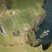
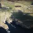
Whaligoe, Square Of Whaligoe, Mill


Dam (Period Unassigned), Watermill (Period Unassigned)
Site Name Whaligoe, Square Of Whaligoe, Mill
Classification Dam (Period Unassigned), Watermill (Period Unassigned)
Alternative Name(s) Whaligoe, Former Watermill; Ulbster
Canmore ID 9004
Site Number ND34SW 119
NGR ND 32140 40484
Datum OSGB36 - NGR
Permalink http://canmore.org.uk/site/9004


- Council Highland
- Parish Wick
- Former Region Highland
- Former District Caithness
- Former County Caithness
ND34SW 119 32140 40484
See also ND34SW 73.
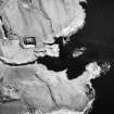
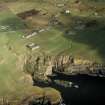
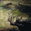
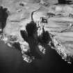
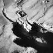
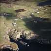
For Whaligoe Harbour and Steps (adjacent to E), see ND34SW 121.00.
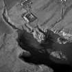
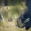
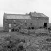
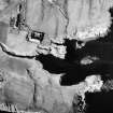
(Location cited as ND 321 404). Corn mill, Whaligoe, Ulbster, mid to late 19th century. A large 3-storey rubble building on an L plan, with two kilns. The wheel was internal, fed by a lade carried on a masonry aqueduct. Apparently gutted and decaying.
J R Hume 1977.
Mill now converted as dwelling (from 1984 HS Listing).
Information from LBLP (GK), February 2004.
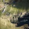
The former corn mill at Whaligoe has been converted into a private house and it was not recorded during the RCAHMS Yarrows survey in 2004. The mill is depicted roofed on both the 1st and 2nd editions of the OS 6-inch map (Caithness 1877, sheet xxix; 1907, sheet xxix). The dam and mill pond are situated 33m N of the mill. Constructed of stone, the central section of the dam was replaced with concrete in the summer of 2004. At that time the pond was drained, revealing that it was no more than about 0.8m in maximum depth.
Visited by RCAHMS (JRS) 12 August 2004

