
Dalsetter


Broch (Iron Age)(Possible), Outworks (Prehistoric), Settlement (Prehistoric)
Site Name Dalsetter
Classification Broch (Iron Age)(Possible), Outworks (Prehistoric), Settlement (Prehistoric)
Alternative Name(s) Boddam; Stack Of The Brough
Canmore ID 899
Site Number HU41NW 1
NGR HU 40757 15671
Datum OSGB36 - NGR
Permalink http://canmore.org.uk/site/899


- Council Shetland Islands
- Parish Dunrossness
- Former Region Shetland Islands Area
- Former District Shetland
- Former County Shetland
HU41NW 1.00 4075 1567
(HU 4075 1567) Brough (OE)
OS 6" map, Shetland, 2nd ed.,(1903).
HU41NW 1.01 4074 1571 Farmstead; Head-dyke
A broch, almost entirely demolished, the site being remarkable for its surrounding defences, as well as for the extent of the area occupied by associated outbuildings. The defences, now best defined on the east, consist of two concentric ramparts separated by a wide ditch and, respectively, 26' and 53' distant from the broch. They are composed mainly of earth, and rise 4'6" to 5' above the bottom of the ditch. The outer one measures from 12' to 15' wide at the base, but the base of the inner one is obscured on the inside by debris from the broch, much of which has been robbed for sheepfolds. Two wells lie just outside the defences.
RCAHMS 1946, visited 1930.
A broch generally as described by RCAHMS. Traces of outbuildings surrounding the broch are too amorphous for survey action. One of the wells lies to the N but the other could not be located.
Surveyed at 1/2500.
Visited by OS (RL) 18th May 1968.
Field Visit (2 September 1930)
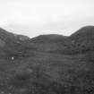
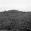
Broch of Dalsetter, near Boddam. The remains of this broch (Fig. 479 [SC 1224200]) lie 50 yds. from the edge of a precipitous cliff at the N. side of the Voe, fully half a mile E. of Boddam and approximately 650 yds. E.S.E. of the farmhouse of Dalsetter. Directly opposite there rises from the sea an isolated mass of rock, which goes by the name of 'The Stack of the Brough'.
The main building has been almost entirely demolished, but a short length of the outer face of its wall is just recognisable among the scattered debris on the S. The site, however, is still remarkable for the surrounding defences, as well as for the extent of the area that has apparently been occupied by associated ‘out-buildings’. In the latter respect it resembles the site at Eastshore (HU41SW 4). The defences (Fig. 478), now best defined on the E., consist of two concentric rings of rampart, separated by a wide ditch and, respectively, 26 ft. and 53 ft. distant from the broch. They are composed mainly of earth, and rise to an average height of from 4 ft. 6 in. to 5 ft. above the bottom of the ditch. The outer one measures from 12 to 15 ft. at the base, but the base of the inner one is obscured on the inside by the fallen material of the broch, many of the stones of which have been utilised for the construction of sheep-folds. Two wells just outside show that the question of a water supply can have presented no difficulty. On the other hand, there is no access to the sea within easy distance.
RCAHMS 1946, visited 2 September 1930.
OS 6" map, Shetland, 2nd ed.,(1903).
Aerial Photography (October 1971)
Oblique aerial photographs of Dalsetter, Shetland, by Mr John Dewar in 1971.
Aerial Photography (October 1973)
Oblique aerial photographs of the remains of the broch at Dalsetter, Shetland, by Mr John Dewar in 1973.
Publication Account (2002)
HU41 3 DALSETTER ('Broch of Dalsetter')
HU/408158
Probable broch in Dunrossness, 50m from a precipitous cliff at the north side of the Voe. Only a short length of the outer wall face is visible on the south. The outer defences are extensive and well preserved, consisting of two concentric ramparts separated by a wide ditch and, respectively, 26 ft. and 53 ft. distant from the broch [1, plan: 2, fig. 278]. They are made mainly of earth and rise from 4.5 - 5.0 ft. above the bottom of the ditch; the basal width of the outer one is 12-15 ft.. Amorphous traces of many outbuildings can be seen and there are two wells just outside the outer rampart.
Sources: 1. OS card HU 41 NW 1 (inc. sketch plan): 2. RCAHMS 1946, vol. 3, no. 1146, 26-7 and pls. 478-9 (plates).
E W MacKie 2002

