
Castle Of Old Wick


Castle (Medieval)
Site Name Castle Of Old Wick
Classification Castle (Medieval)
Alternative Name(s) Old Man Of Wick, Wic 177; Lord Oliphant's Leap; Castle Walk; 'aul' Man O' Wick'
Canmore ID 8956
Site Number ND34NE 2
NGR ND 36921 48834
Datum OSGB36 - NGR
Permalink http://canmore.org.uk/site/8956


First 100 images shown. See the Collections panel (below) for a link to all digital images.
- Council Highland
- Parish Wick
- Former Region Highland
- Former District Caithness
- Former County Caithness
ND34NE 2 36921 48834
(ND 3692 4883) Castle of Old Wick (NR) (Remains of)
Moat (NR) (Remains of)
Lord Oliphant's Leap (NAT)
Castle Walk (NAT)
OS 6" map, Caithness, 1st ed., (1872)
Old Man of Wick
(NAT). Castle (NR) (remains of) (no detail shown).
OS 6"map, (1970)
Location formerly entered as ND 3692 4883.
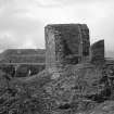
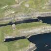
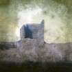
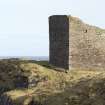
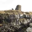
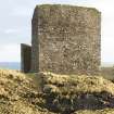
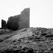
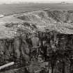
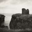
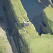
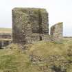
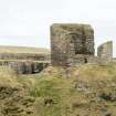
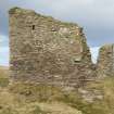
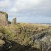
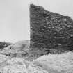
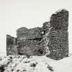
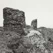
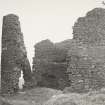
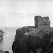
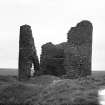
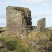
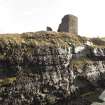
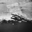
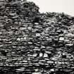
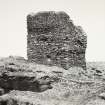
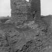
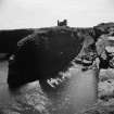
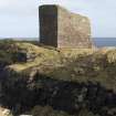
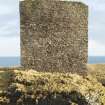
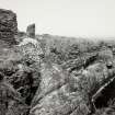
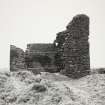
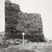
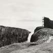
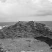
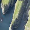
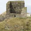
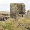
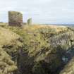
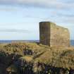
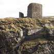
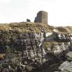
The Castle of Old Wick, by sailors called the Aul' Man o' Wick (NSA 1845) (but see ND34NE 12) is a plain, rectangular keep set near the landward end of a 100 yds long narrow promontory; and is flanked by 100 ft high cliffs and fronted by a 'moat'. An outer rampart crosses the landward end of the promontory.
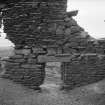
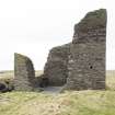
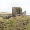
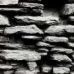
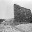
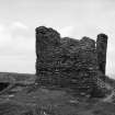
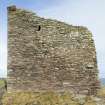
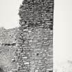
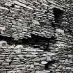
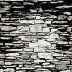
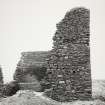
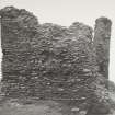
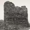
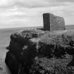
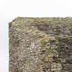
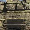
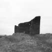
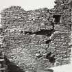
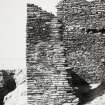
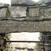
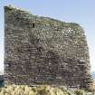
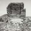
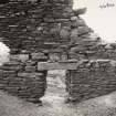
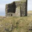
The keep stands to a height of 25 to 30 ft and measures 24 ft by 16 ft 3 ins within walls 7 ft thick. It has consisted of three storeys and a basement, all unvaulted; the doorway has been in the seaward-facing NE wall, probably at first floor level. Each floor has had a window in the SE wall, and on the second floor a single aperture overlooks the landward approach. In the S corner the wall is riven and bulging.
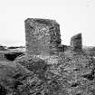
The low outer rampart has crossed the promontory about 30 yds from the keep. In rear of it, on either side of the approach, is the foundation of a small rectangular building.
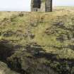
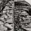
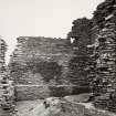
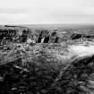
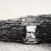
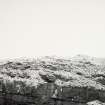
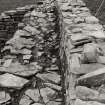
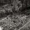
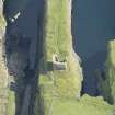
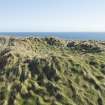
The rock-cut 'moat', 30 ft wide and 10 ft deep, adjoins the keep and may have been crossed by a drawbridge. It is known as "Lord Oliphant's Leap". To the rear of the keep two rows of building foundations flank a roadway, 174 ft long, running along the centre of the promontory to an open area, 70 ft by 47 ft, at the tip, which is said to have been the castle garden, and is now known as Castle Walk. The whole appears at one time to have been enclosed by a wall. Small portions of the foundation can still be traced round the cliff-top (Name Book 1872). Steps lead down to the sea (NSA 1845).
Previously considered to be probably 14th century, the keep is now ascribed to the 12th century by both MacKie (E W MacKie 1975) and Lamb (R G Lamb 1980), the latter comparing it with towers in Orkney and Scandinavia, a diagnostic feature being its standing to one side of the approach rather than forming a gate-house as in later medieval castles. The first known owner of the property was Reginald Cheyne in the mid 14th century. Thereafter it passed by marriage to the Sutherlands in the 14th century, then to the Oliphants in the 15th century. It came to the Sinclairs in 1644, then to Lord Glenorchy, who sold it in 1690 to the Dunbars of Hempriggs, with whom it remained in 1910.
New Statistical Account (NSA, C Thomson, written 1841) 1845; Name Book 1872; RCAHMS 1911, visited 1910; E W MacKie 1975; R G Lamb 1980.
The remains of the Castle of Old Wick, its outbuildings and rock-cut ditch, are generally as described.
Published survey (1:2500) revised.
Visited by OS (W D J) 22 April 1963.
'Castle of Old Wick' (SDD nameplate) is as described by the previous authorities, and is now under guardianship. Steps lead seaward from Castle Walk, but the sea is inaccessible. The name 'Old Man of Wick' published by OS is erroneous, and probably confused with an unlocated natural feature in the vicinity (see ND34NE 12).
Revised at 1:2500.
Visited by OS (N K B) 17 January 1983.
Project (1980 - 1982)
Publication Account (1995)
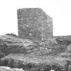
A ruined tower, known to seamen as the Old Man of Wick, stands on a rocky promontory jutting out into the sea, cut off on the landward side by a ditch. What survives is the ruined shell of a simple tower keep, so simple that it has no diagnostic features by which it can be accurately dated. Most probably it was built in the 12th or early 13th century AD, the time when the Norse Earls of Orkney held Caithness from the King of Scotland, and thus it has some claim to be called a Norse castle.
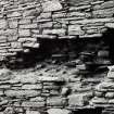
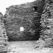
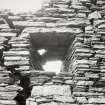
The ditch was originally spanned by a drawbridge, and has the remains of a rampart and gatehouse outside it. The tower had four floors and an attic under a pitched roof, with one room on each floor, and the floor beams carried on scarcement ledges built into the walls. The only entrance was a door to the first-floor hall on the seaward side, but this part of the wall has collapsed, and entry is now through a breach in the wall into the storeroom below. As there are no stairs in the thickness of the wall , all access up and down from the hall must have been by internal wooden ladders. There are no fireplaces or chimneys either, so the rooms may have been heated by braziers set on stone flags let into the wooden floors. Each room had two tiny windows. The only feature built into the walls of this tower was a small chamber on the first floor in the southwest wall, possibly a latrine, of which the last traces can still be made out.
Beyond the tower a passage led down the middle of the narrow promontory past two rows of buildings, now grassed over, to a small courtyard at the end. These buildings will have housed the kitchen,bakehouse, stables, servant's quarters and so on. Down the coast at Forse (ND 224338) is another promontory castle with a small tower of rather similar design, whose date is also uncertain. Both castles belonged to the Cheyne family in the 14th century.
Information from ‘Exploring Scotland’s Heritage: The Highlands’, (1995).
Archaeological Evaluation (14 September 2009 - 23 September 2009)
ND 3692 4883 Two phases of work were carried out 14–23 September 2009. Phase 1: A preliminary photographic record and assessment was made of surviving masonry structures on the NW edge of the promontory to the NE of the square tower. This aimed to provide a baseline assessment of the general condition and extent of the masonry, and to produce an elevation drawing, which would be used to aid later more detailed recording.
Phase 2: During this phase of work a closer examination of the masonry was made possible by rope access provided by a specialist contractor. Although the date and phasing of the structures could not be ascertained with any certainty, it was thought that their primary function was as a revetment, with defence perhaps a secondary consideration due to the natural defences provided by the near-vertical cliffs. The two areas of masonry identified at the SW end of the cliff seem to have a close spatial relationship with the castle’s remaining tower, while the main central section of the masonry appears to end near the midpoint of the range of buildings extending along the promontory, which may suggest it predates the construction of at least some of those structures.
Archive: RCAHMS (intended)
Funder: Historic Scotland
David Murray – Kirkdale Archaeology
OASIS Id: kirkdale1-249665
Note (18 February 2015 - 18 May 2016)
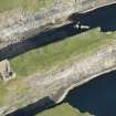
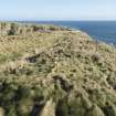
This castle occupies a precipitous promontory on the cliffs S of Old Wick and there is no evidence that it overlies an earlier fort. Nevertheless, the similarities with a series of promontory works on the Caithness and Sutherland coasts, where there are traces of rectangular buildings behind the defences has led to its inclusion here. The defences comprises a ditch about 8.5m in breadth by 3m in depth barring the approach from the landward side, immediately behind which there is a stone keep guarding the only possible access across a causeway on the NW side. To the rear of the keep ranges of building extend for a distance of about 50m along the margins of the promontory to either side of a central roadway, which stops at what appears to have been an enclosure, possibly a garden about 20m short of the seaward end of the summit, which overall measures 85m from ENE to WSW by about 22m transversely (0.18ha). Beyond this the ground descends in a series of steps down to the rocks above the sea.
Information from An Atlas of Hillforts of Great Britain and Ireland – 18 May 2016. Atlas of Hillforts SC2827
Measured Survey (March 2016)
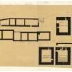
This survey was carried out the spring of 2016 by HES' Survey and Recording Group as a Special Survey. It was selected because of the poor quality of the existing record, and has benefited from the Arts and Humanities Research Council Collaborative Doctoral Award to William Wyeth to study Early Stone Castles, 1050-1350, under the supervision of Professor Richard Oram of Stirling University and Dr Piers Dixon, HES. The survey team included Heather Stoddart, Iain Anderson, Ali McCaig and Steve Wallace, Piers Dixon and William Wyeth (PhD student). The survey comprised measured survey and photography. Laser scan 3D data was compiled for the site which provided a base for the profiles and plans of the site, and the tower in particular. These were drawn up at 1:250 and included a ground plan, a plan of each floor of the tower as well as the profiles. As a Property in Care this data provides a base for conservation as well as interpretation.
Field Visit (March 2016)
The castle of Old Wick occupies a flat-topped rocky promontory overlooking the North Sea. It comprises a peninsular of land extending c100m NE by 20m transversely that falls vertically to the sea to the NW and SE and by steps on the NE. The castle occupies the greater part of this promontory and comprises a rock-cut ditch, a tower, two ranges of outbuildings on either side of a passage or yard with a garden at the NE end. Outside the castle there are two small buildings inside an earthen bank that runs across the neck of the promontory.
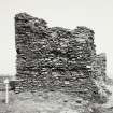
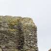
The rock-ditch is 9m in breadth and 3m in depth and encloses an area 85m in length which is defended by a rectangular tower, measuring 11m from NW to SE by 9m transversely and standing to three stories in height that is offset to the SE cliff-edge The entrance to the castle was confined to the space between the tower and the cliff edge to the NW and was protected by a wall, 2m in thickness, now reduced to footings that ran from NW cliff-edge SE towards the tower in line with its NE side. This wall appears to overlie two earlier phases of wall along the cliff-edge on different alignments, which extended to the rock-cut ditch and perhaps along it, although this could not be confirmed at the date of survey. The line of the ditch edge describes a curved arc slightly forward from the tower. Traces of walling were observed along both cliff-edges on the NW and SE outside the line of the current structures.
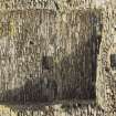
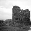
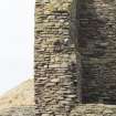
The tower has lost much of its upper floors on the NE and SE, but survives to what appears to be parapet level on the NW and to second floor on the SW. There has been considerable conservation work carried out on the structure some of which has been rebuilt, especially on the SW to landward, SE of the slit window. No entrance is visible but the large gap in the stonework on the NE is most likely to have been where the tower was accessed. The basement was lit by a slit window on the SE, part of the splay of which still survives. Joist holes in the NW end indicate that the first floor was supported by timber, but these have been lost in remedial work on the SE. The first floor is featureless apart from an ingo for a garderobe in the SE. The second floor is supported by a scarcement and there is a small slit window on the SW overlooking the ditch and slightly offset to the NW. In the NW wall there are a pair of joist holes for a lum above a shallow recess for the back of a fireplace. The third floor is supported by a timber floor set on a scarcement in the NW and presumably SE ends. A possible window opening on the NE was suggested by a straight edge in the broken stonework, but could not be confirmed. A joist hole was noted on the NE face at first floor level about 1m from the N corner, suggesting a timber platform, which was confirmed on a postcard of c 1925 (SC1149267), which also shows a joist hole at the same level at the break in the wall where it has collapsed.
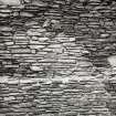
The NW range of buildings comprises two individual buildings which overlies an earlier structure in between the two. The SW of the two is 25m in length by 8m in breadth at its widest, over stony banks, 2m in thickness and up to 1m in height. It is divided into two parts; the NE part is narrower at 6m in breadth and is 13m in length. The NE building is 19m in length by 7m in breadth over stony banks up to 1m in height. It is subdivided into three compartments. The SE range is 30m in length and comprises a small two compartment building overlying two earlier structures. Traces of a curtain wall in the form of a low spread bank extend from the building to NE and SW. The garden beyond is enclosed by an earthen bank, 1m in thickness and up to 0.4m in height. A shallow ditch, possibly modern, was noted that runs across it from NW to SE.
The tower at the Castle at Old Wick has been suggested as another example of a 12th century Norse tower to match Cubbie Roo’s Castle on Wyre. However, simple late medieval rectangular towers of this kind are to be found elsewhere in Caithness at places like Forse, and there is no intrinsic dating in the architecture to suggest Old Wick dates to the 12th century. The RCAHMS Inventory suggests a 14th century date and places reliance on Old Wick being the possession of Reginald Cheyne in c 1350 as was Forse Castle (RCAHMS 1911, No 495; p. 137-9). Like Forse it was accessed at first floor level, on the basis of earlier descriptions of the structure, the NE wall having fallen away to ground level over subsequent years. The window openings, such as they are or were before collapse took most of them away, appear to be late medieval in style rather than Romanesque, with flat Caithness stone lintels. This is a very simple tower in its features and has few of the features that grace larger towers, such as garderobes, stairs or intramural cells, like Braal for example, so that it is easy to fall into the trap of seeing its simplicity as indicating a much earlier date. Structurally the tower looks secondary in its alignment with the ditch, and early images show that there was an adjacent building beside it on the N that guarded access, probably via a drawbridge into the castle of which no trace now survives. Be that as it may, the promontory site could well have been occupied prior to the tower and there are clearly earlier phases of walling along the cliff edge that predate the present structures.
Dendrochronology (22 September 2021 - 23 September 2021)
ND 36921 48834 Work has been undertaken to remove and scientifically date a sole surviving timber fragment from Castle of Old Wick, Caithness. The fieldwork was carried out on 22 and 23 September 2021.
Castle of Old Wick is situated approximately one mile S of Wick. The ruined tower has been variously ascribed to the 12th century or the later 14th century for its initial construction, though no diagnostic architectural features survive to aid this interpretation. A single timber fragment was known to survive within a recess in the NW wall of the tower at second floor level; it was exposed to the elements and at risk of decay. The aim of this project is to retrieve the timber and obtain a scientific date, which will inform our understanding of the castle, and to conserve the remains for future analysis. The timber is believed to be original in-situ material, though its function is still to be fully understood
– possibilities include support for a chimney or the remains of wooden scaffolding. The timber was removed, wrapped and analysed by Dendrochronicle, and the species confirmed as alder, rather than oak, as first thought. This identification has ruled out dendrochronological analysis, but the timber has been sub- sampled for Bayesian radiocarbon dating (‘wiggle match’ dating) at SUERC. Results and interpretation of the radiocarbon dates are forthcoming, expected early 2022.
Archive: NRHE (intended)
Funder: Castle Studies Trust and Historic Environment Scotland
Rachel Pickering and Coralie Mills – Historic Environment Scotland and Dendrochronicle
(Source: DES Vol 22)
Dendrochronology (22 September 2021 - 31 October 2022)
ND 36921 48834 Work has been undertaken to remove and scientifically date a sole surviving timber fragment from Castle of Old Wick, Caithness. Careful removal of the timber and its analysis was undertaken by Coralie Mills and Hamish Darrah, of Dendrochronicle in September 2021 (DES Volume 22, 115). The timber species, alder, ruled out dendrochronological dating and sub-samples were submitted for Bayesian radiocarbon (‘wiggle match’) dating at SUERC.
Castle of Old Wick is situated approximately one mile S of Wick. The ruined tower has been variously ascribed to the 12th century or the later 14th century for its initial construction, though no diagnostic architectural features survive to aid this interpretation. Bayesian analysis of the only two viable sub-samples provided a ‘wiggle match’ date of cal AD 1515–1550 (95% probability), with highest single-year probabilities in the range cal AD 1515–1535 (68% probability). The results represent the bark edge position and the felling date, or death date, of the timber. Careful consideration has been given to what the dating results mean. While our preferred interpretation is that the timber was used freshly cut, a rough notch at the better-preserved inner end could be evidence of re-use. The timber is clearly not part of a floor level and is seen as a fixture for an internal structure built either in or after the first half of the 16th century. The timber was much smaller than the masonry socket in which it sat, with a void behind it, and it may be that the socket is earlier than the timber and re-used for this fixture.
Further analysis in response to this new dating evidence was
undertaken by Dr Will Wyeth for HES. He has concluded the timber element was part of a hanging lum, a feature found in middling- and high-status buildings in the 15th and 16th centuries. A study of documentary sources connects the phase of works implied by the timber felling date with repairs following a period of destruction and looting of Castle of Old Wick before 1517. The results of renewed interrogation of the surviving fabric in concert with the ‘wiggle match’ data give greater confidence that the standing fabric of Castle of Old Wick dates from the later medieval period. Archive: NRHE (intended)
Funder: The Castle Studies Trust and Historic Environment Scotland
Laura Harrison, Coralie Mills and Georgina Ritchie – Historic Environment Scotland and Dendrochronicle
(Source: DES Volume 23)

