
Strathan


Head Dyke (Post Medieval), Township (Period Unassigned)
Site Name Strathan
Classification Head Dyke (Post Medieval), Township (Period Unassigned)
Canmore ID 89524
Site Number NC02SE 18
NGR NC 087 209
NGR Description centred on NC 087 209
Datum OSGB36 - NGR
Permalink http://canmore.org.uk/site/89524


- Council Highland
- Parish Assynt
- Former Region Highland
- Former District Sutherland
- Former County Sutherland
NC02SE 18 centred on 087 209
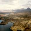
A township comprising twenty-five roofed and twelve unroofed buildings, one of which is an angled, four compartment, long building, a head-dyke is depicted on the 1st edition of the OS 6-inch map (Sutherland 1878, sheet lxix). Fourteen roofed and twenty-three unroofed buildings, a head-dyke and some field walls are shown on the current edition of the OS 1:10,000 map (1971).
Information from RCAHMS (SAH) 8 September 1995
Site recorded during a survey of the intertidal zone and the coast edge (50m from the mean high tide mark) between the Rivers Ullapool and Culag.
Further details can be found in a report submitted to Historic Scotland.
NC 083 213 Rectangular building, peat cuttings (NC02SE 18).
Sponsors: Historic Scotland, Glasgow University Archaeology Department.
A Long 1996
Field Visit (30 November 2009)
The modern village of Strathan is now located on the road. To the south of the modern township there are five ruinous stone built structures on the north facing slopes of a hill. Stone dykes were also observed running along the contours of the hill leading up to the possible head dyke which runs E-W. In the flatter area at the base of the valley lazy beds or rig and furrow were observed.
(HLP_no 52)
Assynt's Hidden Lives Project 2009

