
Halberry Castle


Castle (Medieval)
Site Name Halberry Castle
Classification Castle (Medieval)
Alternative Name(s) Lat 225
Canmore ID 8945
Site Number ND33NW 4
NGR ND 3011 3771
Datum OSGB36 - NGR
Permalink http://canmore.org.uk/site/8945


- Council Highland
- Parish Latheron
- Former Region Highland
- Former District Caithness
- Former County Caithness
ND33NW 4 3011 3771.
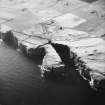
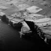
(ND 3011 3771) Halberry Castle (NR) (remains of)
OS 6" map, (1971)
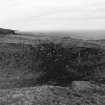
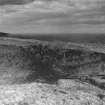
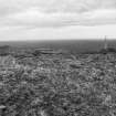
The foundation of a rectangular keep, 44 by 28ft, which is said to have belonged to the Crowner Gunn in the 15th century. The promontory on which it stood has been crossed at the neck by a rock-cut ditch about 25ft wide.
RCAHMS 1911.
Halberry Castle is the turf-covered footings of a tower, 19.0 by 6.0 by 0.6m high, defended on the landward side by a deep ditch spanned by a causeway. The ditch appears to have been mutilated by quarrying at its NW end. From a point 4.0m NW of the tower, there is a low turf-covered wall running N across the promontory forming a second line of defence, the gap between the wall and tower being the entrance.
Between the tower and the ditch are the vague footings of a rectangular building, 8.0 by 4.5m, which is probably contemporary with the tower. Name but not date verified.
Resurveyed at 1:2500.
Visited by OS (N K B) 11 May 1967.
Field Visit (1911)
The foundation of a rectangular keep, 44 by 28ft, which is said to have belonged to the Crowner Gunn in the 15th century. The promontory on which it stood has been crossed at the neck by a rock-cut ditch about 25ft wide.
RCAHMS 1911.
Field Visit (11 May 1967)
Halberry Castle is the turf-covered footings of a tower, 19.0 by 6.0 by 0.6m high, defended on the landward side by a deep ditch spanned by a causeway. The ditch appears to have been mutilated by quarrying at its NW end. From a point 4.0m NW of the tower, there is a low turf-covered wall running N across the promontory forming a second line of defence, the gap between the wall and tower being the entrance.
Between the tower and the ditch are the vague footings of a rectangular building, 8.0 by 4.5m, which is probably contemporary with the tower. Name but not date verified.
Resurveyed at 1:2500.
Visited by OS (N K B) 11 May 1967.
Project (1980 - 1982)

