
Gunn's Castle, Bulnacraig


Castle (Medieval)
Site Name Gunn's Castle, Bulnacraig
Classification Castle (Medieval)
Alternative Name(s) Lat 224
Canmore ID 8944
Site Number ND33NW 3
NGR ND 3074 3857
Datum OSGB36 - NGR
Permalink http://canmore.org.uk/site/8944


- Council Highland
- Parish Latheron
- Former Region Highland
- Former District Caithness
- Former County Caithness
ND33NW 3 3074 3857.
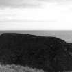
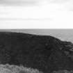
(ND 3074 3857) Gunn's Castle (NR) (remains of)
OS 6" map, (1971)
The ruins of a small rectangular keep about 37 by 23ft with walls some 3ft thick, on a peninsular rock isolated by a wall built on a rock shelf. Immediately outside the buiding at the NE angle is a circular depression, some 9ft in diameter and 2 to 3ft deep, probably indicating a well. The castle was a stronghold of the Gunns.
T Sinclair 1890; RCAHMS 1911.
The turf-covered footings of a tower, 0.5m high, known locally as 'Gunn's Castle' (information from G Sutherland, Bridgend, East Clyth, Caithness) generally as described by the RCAHMS except that the outer wall to the SW has been destroyed by erosion, and the alleged wall is probably a natural sink-hole caused by drainage through a rock fault. Date not ascertained.
Visited by OS (N K B) 10 April 1967.
Project (1980 - 1982)

