
Camster


Hut Circle (Prehistoric)(Possible)
Site Name Camster
Classification Hut Circle (Prehistoric)(Possible)
Canmore ID 8696
Site Number ND24SE 19
NGR ND 2603 4425
Datum OSGB36 - NGR
Permalink http://canmore.org.uk/site/8696


- Council Highland
- Parish Wick
- Former Region Highland
- Former District Caithness
- Former County Caithness
ND24SE 19 2603 4425
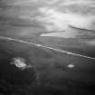
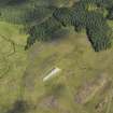
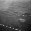
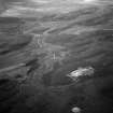
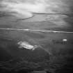
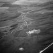
To the NE of the Camster long cairn (ND24SE 1) is a circular depression with a partly-defined peat-covered bank around its rim measuring 6.5m between its centres. There are traces of what may be an entrance in the SSE. This may be a hut circle, but it is too ill-defined to classify positively.
Visited by OS 12 April 1972.

