
Wag Of Forse


Dun (Period Unassigned), Field System (Period Unassigned), Settlement (Period Unassigned)
Site Name Wag Of Forse
Classification Dun (Period Unassigned), Field System (Period Unassigned), Settlement (Period Unassigned)
Alternative Name(s) Wag O' Forse
Canmore ID 8608
Site Number ND23NW 1
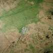
NGR ND 2048 3520
Datum OSGB36 - NGR
Permalink http://canmore.org.uk/site/8608


- Council Highland
- Parish Latheron
- Former Region Highland
- Former District Caithness
- Former County Caithness
ND23NW 1 2048 3520
See also ND23NW 7 and ND23NW 17.
(ND 2048 3520) Dun and Settlement (NR)
OS 1:10,000 map, (1976)
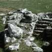
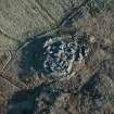
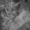
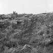
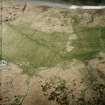
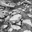
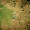
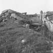
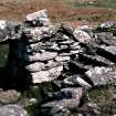
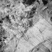
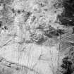
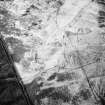
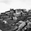
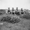
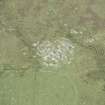
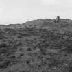
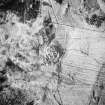
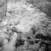
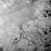
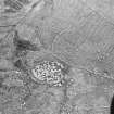
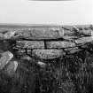
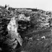
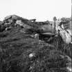
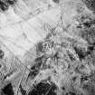
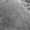
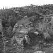
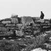
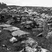
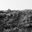
Wag of Forse: An Iron Age site with successive periods of occupation including a dun (Young 1964; MacKie 1965) and wags, apparently only part of a complex which extends along the E edge of a rocky outcrop. It was partly excavated by Curle (1941; 1948) in 1939 and 1946-8.
The sequence of occupation appears to consist of huts of three periods, overlaid by a dun, which was succeeded and partly destroyed by wags, both elongated and round. The site is partly bounded by a turf wall on a substantial stone base with, at least on the W, an external, V-shaped ditch, the period of which is unknown.
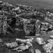
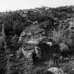
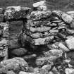
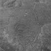
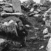
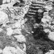
MacKie (1965) likens the dun, with its massive double entrance to the pre-broch gatehouse forts of Shetland. It measures 47ft in internal diameter within a wall 4 to 5ft thick, rising from a heavy scarcement. Just inside the entrance a flight of stairs leads off to the ruined wall-head (recalling the entrances to some of the Caithness brochs, including that at Yarrows - ND34SW 1).
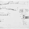
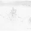
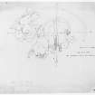
Excavation finds, most of which were donated to the NMAS, included several saddle-querns but only one, broken, rotary quern. From the original hearth in hut 'C' (see plan) came a pot with LBA-EIA parallels (1965). The most sophisticated pottery came from a small round wag, not shown on plan, in area 'H'. No metal was noted.
A O Curle 1941; 1948; 1950; A Young 1964; E W MacKie 1965.
A partially excavated Iron Age occupation site, consisting of a dun and galleried dwellings, as described and illustrated by Curle. Excavated material overlies some of the dwellings and the outer turf-covered wall, rendering their identification virtually impossible.
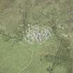
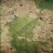
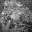
There are undoubtedly more huts beneath the tumble, and also to the S (see ND34SW 7 and ND34SW 12 ) where numerous large slabs protrude through the turf. There was an associated field system, evidenced by a low bank running from the outer rampart, but this has been destroyed by much later field walls and cultivation, and cannot be accurately determined. Resurveyed at 1:2500.
Visited by OS (N K B) 11 May 1967.
If the primary structure is a dun it is unique although the stair in the entrance section has analogies in the Keiss brochs (ND36SE 2 and ND36SE 3 ).
The secondary longhouses are unusual in the British Iron Age but may bear comparison with the wooden longhouses with internal rows of roof-posts of the northern European Iron Age.
'It is quite possible that at Forse we have a rare fragment of evidence for the arrival in north-east Scotland of prehistoric settlers direct from the continent, an influx of people who may have laid the foundations of the Pictish nation of proto-historic times. Certainly the dun appears to be earlier than the Caithness brochs and to have contributed some elements of its architecture to them.
E W MacKie 1975.
The entrance block in the circular ring-fort differs from that of the blockhouse forts in that the structure does not project forwards beyond the curve of the wall, which externally it does not interrupt, and it is of one build with the wall.
R G Lamb 1980.
No change to the previous reports except that the protruding slabs noted to the S by the previous field investigator do not appear to have any archaeological significance.
Visited by OS (J M) 24 March 1983.
Classified by Close-Brooks as broch and settlement.
J Close-Brooks 1986.
Scheduled with ND23NW 7 and ND23NW 17.
Information from Historic Scotland, scheduling document dated 30 January 2003.
Publication Account (1995)
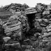
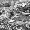
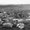
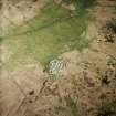
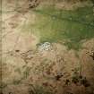
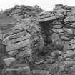
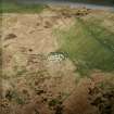
Forse Wag now appears as a great spread of stones with structures emerging out of the tumble. It was partially and rather clumsily excavated between 1939 and 1948. The settlement began as a group of stone huts that were replaced by a broch, which was in turn robbed to build a series of pillared houses. 'Wag' is the local name for these houses and may derive from a Gaelic word meaning 'little cave'.
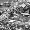
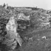
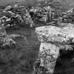
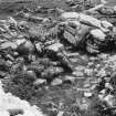
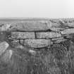
On the north is the circular wall of the broch, with its entrance flanked by a stair and a gallery in the wall. Most of the interior of the broch and its south wall were destroyed when a long rectangular house was built over it. Another long house stands west of the broch. This is 12m long and has the remains of two rows of upright, pillar-like stones inside which supported the roof. Stone lintels crossed from wall to pillar, and between pillars, so that the areas between could easily be roofed with flagstones, perhaps then covered with turf. One lintel is still in position. There is a long entrance passage with door checks, and two side entrances lead off to other rooms or houses, one of which is round and has one stone pillar still standing. Beyond is a complex series of buildings, some early, only partly excavated. The L-shaped structure west of the site is the excavator's stone dump.
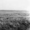
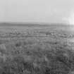
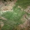
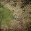
In the fields round Forse Wag a number of other structures can be found, including hut circles to the west. Looking south, a noticeable green hump by an old stream bed is the grassed-over remains of three burnt mounds, while over to the northeast a large grassy mound in the distance is an unexcavated broch. Most of the stone field walls round the broch belong to a more recent, though pre-improvement, farming settlement. Traces of cultivation strips can be seen within the walls.
Information from ‘Exploring Scotland’s Heritage: The Highlands’, (1995).
Publication Account (2009)
ND23 14 WAG OF FORSE
ND/2048 3520
This domestic site (with stone long-houses) and dun in Latheron, Caithness, forms a curious complex of structures which was partially excavated by A O Curle just before the last war and again in 1947 and 1948 [2, 3 and 4] (visited in 1971) A short description of the site is included here for three reasons.
The first is that a case can be made out for assigning the circular building to a pre-broch period, and the second is that the material culture found – while it cannot be related to specific structures – supports that idea. The third reason is that the site was evidently occupied over a long period by people who built a variety of structures, and would repay further investigation and accurate dating. Like all other Iron Age structures in Caithness apart from brochs there is an absolute lack of precise dating evidence for the rectangular wags, or galleried dwellings.
The site’s name
The curious term ‘wag’ was explained by Curle who had first noticed the long rectangular structures – termed “galleried dwellings” – in 1910 during fieldwork in Caithness for the second report of the Royal Commission.
“Hitherto un-noticed by modern antiquaries, they were designated on the maps of the Ordnance Survey by the comprehensive but inapplicable term ‘Picts’ Houses.’ The occasional place-name ‘Wag’ or ‘Wagmore’ occurring in their immediate vicinity seems to indicate their original designation, a term for which a derivation has been suggested in the Gaelic word uamh – a cave, with its diminutive uamheg – pointing to the fact that the completed structure under a roof must have presented a cave-like appear-ance.” [3]
(Uamh is pronounced approximately ‘’weem’ which term is a traditional one for underground structures like souterrains. It is also found in place names like East Wemyss (pron. ‘Weems’) in Fife, where there are a number of caves along the shore.)
Description
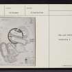
There were two main types of structures at this site, namely the stone longhouses just mentioned, with rows of orthostats (presumably roof supports) standing inside, and small circular or near -circular chambers. In addition there was one large round building called the 'circular wag' but which is more like a dun or fort than anything else; it was diagnosed as a cattlefold by the excavator [3]. The whole complex had evidently been occupied over a period of time and the buildings were not all of the same age. However since no detailed stratigraphy was observed apart from the relationships between adjacent walls, and in many cases the floors of structures were not properly cleared, the detailed history of the site remains obscure. The complex was surrounded by a turf wall.
The 'circular wag' on the north side is earlier than at least one of the long rectangular stone buildings which overlies it; however it seems not to have been the earliest structure on the site. Its internal diameter is 13.73m (45 ft) or 14.33m (47 ft) on the plan, and the wall is 1.22-1.53m (4-5ft) thick except at two places. The first is the main entrance, where the wall had been thickened inwards, and again at about 3 o'clock where it had again been extended inwards in a bulge to accommodate a mural chamber.
The main entrance was only 90cm (3ft) high and the outer lintel was massive and sub-triangular; the passage was 76cm (2ft. 6in) wide. Checks for the door were 1.2m (4 ft) in but there were no bar-holes. A "light" socket stone suggested to Curle that the door had been wooden. The entrance passage was 3.97m (13ft) in length (measured from the plan) and the plan and text suggest that the entrance section had been built separately as a thicker block of masonry. Half way down the passage a stair rose to the wallhead on the left and opposite its foot, in the right wall, was a narrow chamber or guard cell. Seven steps remained of the stair, 1.14m (3ft. 9in) wide and, by prolonging the angle of ascent of the steps to the end of the entrance section and allowing for a platform at the top, an original height for the wall of 3.05-3.66m (10-12ft) was inferred. At a later stage the inner end of the passage was blocked and a new entrance pushed through the back of the guard cell. There was another entrance, also thought to be original by the excavator, through the thin part of the wall at about 8.30 o'clock.
Two rectangular longhouses had been built partly over the circular structure and two more were a short distance south-west of the circular building. A curious building, containing two chambers forming a figure-of-eight, underlay one of the latter.
Discussion
The rarity of this complex site makes it difficult to suggest plausible affinities for the circular building, or to offer a guess at its age better than ‘Iron Age’. The way in which the exploration was conducted precludes much in the way of reliable inference about its function; the idea of a cattlefold seems inherently improbable because of the narrowness of the passage (76cm) and also because a formal stone door-frame built into the passage seems excessive for animals, even if they could have been squeezed down the passage (of course Iron Age cattle were smaller than their modern counterparts). Some kind of defensive stronghold, or dún, seems more likely, and the lengthened entrance passage surely supports this idea (as it argues against the cattlefold theory). The stairs leading from the entrance to the wallhead should be for a watchman and the narrow chamber, or guard cell, opposite its foot also suggests defence. On the other hand the later rectangular stone longhouses were surely for domestic purposes and the dun (if it was such) had presumably ceased to be needed for defence by the time they were erected around it.
The fact that the finds are without precise contexts also hinders the interpretation of the site. A few of them suggest that the site continued in use until the broch period in Caithness; the rotary quern in particular favours this dating, as does the whorl or bead made from a human femur head, a typical broch artifact. Likewise the fine jar sherd with an everted rim suggests the same. However some of the other material recalls the simple early Iron Age (even late Bronze Age) material culture of the mainland hillforts further south. The jet armlets are a case in point as also is the 'cooking pot' found on one of the hearths.
These last are examples of the characteristic Dunagoil vase, with a slightly turned-out rim with a row of shallow finger-impressions immediately below it, which was found in the late Bronze Age levels at Crosskirk (ND07 2) and at Sheep Hill in West Dunbartonshire (MacKie 1976, fig. 6). In the light of this pot, and also because of the absence of any broch-like architectural features, it seems reasonable to suggest that the site at Forse was established in the early Iron Age and perhaps continued in occupation until the early broch period. Evidence for this at two Caithness brochs – Yarrows and Keiss North – has been described [5] and is reviewed again below (ND34 17 and ND36 5). In essence it consists of the presence in these two sites of what appears to be a primary intra-mural stair rising from one side of the entrance passage. This feature is otherwise unknown in brochs and could be reason-ably explained by the example nearby in the older dun at Forse. Other potsherds from the site are indistinguishable from Caithness/Orkney broch jars and imply a middle Iron Age occupation.
Finds: most of these are not clearly assigned to the various structures which are marked on the plan but they include the following.
Stone: fragments of 3 saddle querns, hammerstones, several jet rings and armlets (two of the latter being 8.3 and 10.2cm (3.25 and 4 ins) in diameter), parts of a rotary quern and1 sandstone disc bead. From the small circular Chamber A, supposedly later than the adjacent longhouse A, came 1 polished sandstone disc.
Bone: from below the floor of the circular structure came a human femur-head whorl, 1 stone whorl, 2 saddle querns (used as paving), stone 'pot lids', and fragments of a cannel coal ring.
Pottery: also from the small circular Chamber A, came potsherds (including the pot illustrated by Curle [2, pl. lx].
Sources: 1. NMRS site no. ND 23 NW 1: 2. Curle 1941: 3. Curle 1946: 4. Curle 1948: 5. Young 1962: 6. MacKie 1969: 7. Baines 1999, 77-8: 8. Cowley 1999, 71.
E W MacKie 2007

