
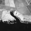
Clyth Harbour


Harbour (Period Unassigned)
Site Name Clyth Harbour
Classification Harbour (Period Unassigned)
Canmore ID 8600
Site Number ND23NE 31
NGR ND 27989 35718
Datum OSGB36 - NGR
Permalink http://canmore.org.uk/site/8600


- Council Highland
- Parish Latheron
- Former Region Highland
- Former District Caithness
- Former County Caithness
ND23NE 31 27989 35718
Clyth Harbour [NAT]
OS (GIS) MasterMap, 30 December 2010.
The available map evidence indicates only a prominent natural indentation; no artificial works are apparent.
The status and significance of the roofless buildings that are indicated to the N, NW and E of the harbour (around ND 2792 3584, ND 2789 3577 and ND 2809 3573 respectively) remains unclear, but they were presumably associated with it.
Information from RCAHMS (RJCM), 30 Decemeber 2010.

