 |
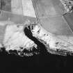
On-line Digital Images |
SC 1693383 |
RCAHMS Aerial Photography |
Oblique aerial view. |
1991 |
Item Level |
|
 |
On-line Digital Images |
SC 1926333 |
Caithness Coastal Survey |
Maps of Latheron parish. Negative Available. |
1982 |
Item Level |
|
 |
On-line Digital Images |
SC 1926334 |
Caithness Coastal Survey |
Maps of Latheron parish. Negative Available. |
1982 |
Item Level |
|
 |
On-line Digital Images |
SC 1926335 |
Caithness Coastal Survey |
General survey area plan. |
1982 |
Item Level |
|
 |
On-line Digital Images |
SC 1926345 |
Caithness Coastal Survey |
Maps of Latheron parish |
1982 |
Item Level |
|
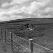 |
On-line Digital Images |
SC 1943994 |
Caithness Coastal Survey |
|
1982 |
Item Level |
|
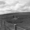 |
On-line Digital Images |
SC 1943995 |
Caithness Coastal Survey |
|
1982 |
Item Level |
|
 |
On-line Digital Images |
SC 2353387 |
Records of the Ordnance Survey, Southampton, Hampshire, England |
Clyth Harbour, ND23NE 25, Ordnance Survey index card, Recto |
1958 |
Item Level |
|
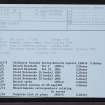 |
On-line Digital Images |
SC 2353388 |
Records of the Ordnance Survey, Southampton, Hampshire, England |
Clyth Harbour, ND23NE 25, Ordnance Survey index card, Recto |
1958 |
Item Level |
|


