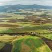
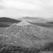
 |
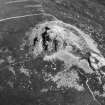
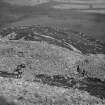
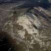
On-line Digital Images |
SC 337195 |
RCAHMS Aerial Photography |
Cropped oblique aerial view. |
1975 |
Item Level |
|
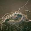 |
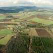
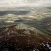
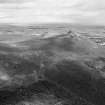
On-line Digital Images |
SC 636483 |
RCAHMS Aerial Photography |
Oblique aerial view of Mither Tap of Bennachie centred on the remains of the fort, taken from the ESE. |
8/5/2000 |
Item Level |
|
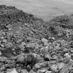 |
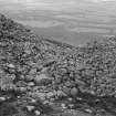
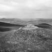
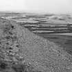
On-line Digital Images |
SC 679156 |
Records of the Society of Antiquaries of Scotland, Edinburgh, Scotland |
View of fort.
Original negative captioned: 'Bennachie Hill-fort. Foundations between outer and inner ramparts near gateway into fort / August 1904'. |
8/1904 |
Item Level |
|
 |
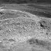
On-line Digital Images |
SC 679192 |
Records of the Society of Antiquaries of Scotland, Edinburgh, Scotland |
View of interior of fort.
Original negative captioned: 'Bennachie Hill-Fort. Passage way inside exterior wall, apparently ending in circular chamber. Entrance to passage in foreground. / Aug. 1904'. |
8/1904 |
Item Level |
|
 |
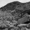
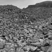
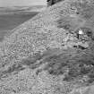
On-line Digital Images |
SC 679214 |
Records of the Society of Antiquaries of Scotland, Edinburgh, Scotland |
View looking down on interior of fort.
Original negative captioned: 'Bennachie Hill-Fort. View fom top of inner rampart / Aug 1904'. |
8/1904 |
Item Level |
|
 |
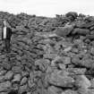
On-line Digital Images |
SC 679218 |
Records of the Society of Antiquaries of Scotland, Edinburgh, Scotland |
View of entrance, from inside.
Original negative captioned: 'Bennachie Hill-Fort. Entrance to fort viewed from inside. 1904'. |
1904 |
Item Level |
|
 |
On-line Digital Images |
SC 679219 |
Records of the Society of Antiquaries of Scotland, Edinburgh, Scotland |
View of entrance from outside.
Original negative captioned: 'Bennachie Hill-Fort. Entrance from outside. Inner rampart in background. / August 1904'. |
8/1904 |
Item Level |
|
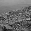 |
On-line Digital Images |
SC 679322 |
Records of the Society of Antiquaries of Scotland, Edinburgh, Scotland |
View of interior of fort.
Original negative captioned: 'Bennachie Hill-Fort. Remains of Circular Foundations within inner rampart, viewed from above. August 1904'. |
8/1904 |
Item Level |
|
 |
On-line Digital Images |
SC 872646 |
RCAHMS Aerial Photography |
General oblique aerial view looking across Kemnay Golf Course towards Bennachie, taken from the SSE. |
3/3/2003 |
Item Level |
|
 |
On-line Digital Images |
SC 872649 |
RCAHMS Aerial Photography |
General oblique aerial view looking across Monymusk village towards Bennachie, taken from the SSE. |
3/3/2003 |
Item Level |
|
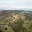 |
On-line Digital Images |
SC 872650 |
RCAHMS Aerial Photography |
General oblique aerial view from Craigmeadow farmsteading, taken from the SW looking NE along the River Don towards Bennachie, with My Lord's Throat on the left side of photograph. |
3/3/2003 |
Item Level |
|
 |
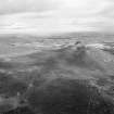
On-line Digital Images |
SC 924510 |
RCAHMS Aerial Photography |
Oblique aerial view centred on the fort taken from the SE. |
1/3/1999 |
Item Level |
|
 |
On-line Digital Images |
SC 924511 |
RCAHMS Aerial Photography |
Oblique aerial view centred on the fort taken from the SSW. |
1/3/1999 |
Item Level |
|
 |
On-line Digital Images |
SC 924512 |
RCAHMS Aerial Photography |
Oblique aerial view centred on the remains of the fort taken from the W. |
8/3/1999 |
Item Level |
|
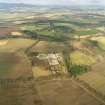 |
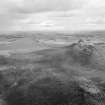
On-line Digital Images |
SC 961128 |
RCAHMS Aerial Photography |
Oblique aerial view of the tower-house and its policies with Bennachie in the background, taken from the S. |
3/3/2003 |
Item Level |
|
 |
On-line Digital Images |
SC 1010443 |
Records of Aberdeen Aerial Surveys, Aberdeen, Scotland |
Oblique aerial view centred on the remains of the fort at Mither Tap of Bennachie, looking to the NW. |
3/8/1985 |
Item Level |
|
 |
On-line Digital Images |
SC 1010444 |
Records of Aberdeen Aerial Surveys, Aberdeen, Scotland |
Oblique aerial view centred on the remains of the fort at Mither Tap of Bennachie, looking to the WNW. |
3/8/1985 |
Item Level |
|
 |
On-line Digital Images |
SC 1010445 |
Records of Aberdeen Aerial Surveys, Aberdeen, Scotland |
Oblique aerial view centred on the remains of the fort at Mither Tap of Bennachie, looking to the NE. |
3/8/1985 |
Item Level |
|
 |
On-line Digital Images |
SC 1010446 |
Records of Aberdeen Aerial Surveys, Aberdeen, Scotland |
Oblique aerial view centred on the remains of the fort at Mither Tap of Bennachie, looking to the NE. |
3/8/1985 |
Item Level |
|
 |
On-line Digital Images |
SC 1010447 |
Records of Aberdeen Aerial Surveys, Aberdeen, Scotland |
Oblique aerial view centred on the remains of the fort at Mither Tap of Bennachie, looking to the NE. |
3/8/1985 |
Item Level |
|
 |
On-line Digital Images |
SC 1010448 |
Records of Aberdeen Aerial Surveys, Aberdeen, Scotland |
View centred on the ramparts of the fort at Mither Tap of Bennachie, looking to the NE. |
3/8/1985 |
Item Level |
|
 |
On-line Digital Images |
SC 1010449 |
Records of Aberdeen Aerial Surveys, Aberdeen, Scotland |
View centred on the ramparts of the fort at Mither Tap of Bennachie, looking to the NE. |
3/8/1985 |
Item Level |
|
 |
On-line Digital Images |
SC 1010450 |
Records of Aberdeen Aerial Surveys, Aberdeen, Scotland |
View centred on the ramparts of the fort at Mither Tap of Bennachie, looking to the NE. |
3/8/1985 |
Item Level |
|
 |
On-line Digital Images |
SC 1010451 |
Records of Aberdeen Aerial Surveys, Aberdeen, Scotland |
View centred on the ramparts of the fort at Mither Tap of Bennachie, looking to the N. |
3/8/1985 |
Item Level |
|


