 |
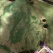
On-line Digital Images |
SC 379138 |
RCAHMS Aerial Photography |
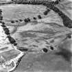
Oblique aerial view. |
1992 |
Item Level |
|
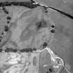 |
On-line Digital Images |
SC 842749 |
RCAHMS Aerial Photography |
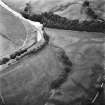
Oblique aerial view. |
1992 |
Item Level |
|
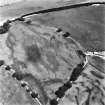 |
On-line Digital Images |
SC 1759312 |
RCAHMS Aerial Photography |
Oblique aerial view. |
1992 |
Item Level |
|
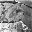 |
On-line Digital Images |
SC 1759313 |
RCAHMS Aerial Photography |
Oblique aerial view. |
1992 |
Item Level |
|
 |
On-line Digital Images |
SC 1759314 |
RCAHMS Aerial Photography |
Oblique aerial view. |
1992 |
Item Level |
|
 |
On-line Digital Images |
SC 1759319 |
RCAHMS Aerial Photography |
Oblique aerial view. |
1992 |
Item Level |
|
 |
On-line Digital Images |
SC 1917584 |
Records of the Royal Commission on the Ancient and Historical Monuments of Scotland (RCAHMS), Edinbu |
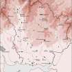
Map showing the distribution of stone axes and Neolithic monuments (long cairns, bank barrow, standing stones, cursus, stone circles, henges and pitted enclosures) in Annandale and Eskdale. Published in Eastern Dumfriesshire: an archaeological landscape. |
1996 |
Item Level |
|
 |
On-line Digital Images |
SC 1917643 |
Records of the Royal Commission on the Ancient and Historical Monuments of Scotland (RCAHMS), Edinbu |
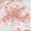
Map showing the distribution of Neolithic monuments in southern Scotland; cursus monuments, bank barrows, pitted avenues, large ritual enclosures, possible mortuary enclosures and interrupted-ditch enclosures in Annandale and Eskdale. Published in Eastern Dumfriesshire: an archaeological landscape. |
1996 |
Item Level |
|
|
On-line Digital Images |
AT 003605 |
RCAHMS Aerial Transcription |
Imagery and Mapping Files for Aerial Photo Transcription. |
26/7/2012 |
Item Level |
|


