
Castlehill, Harbour


Harbour (19th Century)
Site Name Castlehill, Harbour
Classification Harbour (19th Century)
Alternative Name(s) Castletown; Dunnet Bay; House Head
Canmore ID 8416
Site Number ND16NE 41
NGR ND 19800 68618
Datum OSGB36 - NGR
Permalink http://canmore.org.uk/site/8416


- Council Highland
- Parish Olrig
- Former Region Highland
- Former District Caithness
- Former County Caithness
ND16NE 41.00 19800 68618
Harbour [NAT]
OS 1:10,560 map, 1970.
ND16NE 41.01 ND 19845 68491 Boathouse
For (associated) Castlehill Pavement Works (ND 195 685), see ND16NE 42.00.
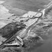
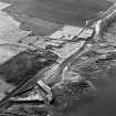
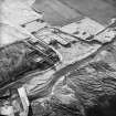
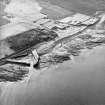
(Location cited as ND 198 686). Castlehill Harbour, built for shipping flagstones in the early 19th century. A classic harbour of enclosure with a stilling basin, built of local flagstones, some set vertically. An interesting feature is the large quayside area for stock-piling flagstones for loading. Nearby is a large vaulted ice-house, with the earth cover largely eroded.
J R Hume 1977.
(Location cited as ND 198 687). Castlehill: this small harbour was paid for by the proprietor, an exporter of paving stones from the Castlehill quarries [Castlehill Pavement Works: ND16NE 42.00] and other local sources. The New Statistical Account describes it as 'neat and commodious', and states that it was being used in 1840 by other craft as well as the proprietor's own. Coal was likewise being imported. Design and construction of the harbour were by Bremner, and if Mowat is correct in stating that Bremner's first use of vertically-set flagstones was at Keiss (ND36SE 27.00), the Castlehill harbour was begun after 1818. The first export of paving stones from Castlehill is said to have taken place in 1825, the harbour having been constructed of the same material it was to export; the same coincidence occurred at Easdale (NM71NW 4) and Laroch (NN05NE 12) in Argyll. Boom gates were used to enable excavation of the pumped-out harbour basin.
Structure
A short distance W of House Head [name: ND 1994 6855], where the sands of Dunnet Bay give way to the rocks of its SW side, a pocket in these rocks has been made into a small harbour. At low tide, the rock foundations are exposed. On these, immense flagstones, the largest showing a face 14ft 6ins (4.4m) long and 6ins (15.2cm) high, have been laid. The NW pier, 300ft (91.4m) long, is of lateral flagstones, backed by others packed upright, side by side, presenting (in accordance with Bremner's theory of resistance to wave action) narrow faces to the sea.
These vertical flagstones are of uneven size, some being over 5ft (1.5m) high, and are set up in three consequently uneven courses or tiers, the fitting together of which to achieve a level top and a consistently battered face is a remarkable product of pragmatic engineering. The parapet, less affected by recent reconstruction at the sea end than it is nearer the shore, consists of more vertically laid flagstones, packed against the inner face of the upper tier of those already described. The top of the parapet verticals form a breast work which slopes gently inwards, and is held in place by a wall of lateral flagstones resting on the pier surface. The heavy parapet turns southwards, crossing the pier surface, from which its own upper level, here flattened, is reached by a flight of steps over a yard (0.914m) wide, and continues forming the upper course of the return head. Two further angles are seen on this side of the harbour mouth, and the lateral flagstones used in the construction have been shaped with very great skill. The two final courses of the outer side of the return head make a low platform with a concave curved front facing toward the harbour entrance. On this stand one rough wooden pawl and one mushroom-shaped one of a pale granite. Another wooden pawl and one of dark flagstone are set on either side of the steps up to the return head.
The shore end of the NW pier is flanked on the inner side by a beach 50yds (45.7m) wide, beyond which a quay built of large stone blocks on natural rock projects 60ft (18.3m) from the shore. Its E end is recessed, and the sand has accumulated around a slipway. The SE pier, which also presents to seaward a tiered face of vertically set stones, many over 3ft (0.914m) high, extends from the end of the shore quay towards the narrow opening between it and the angled tip of the return head of the pier opposite. The inner face of its parapet has also been reconstructed, but an apparently original flight of steps rises, as on the NW pier, from the lower pier surface to the platform made by the end of the parapet overlooking the harbour mouth. The slots or grooves for the boom gates have been most carefully built into the faces of the sides of the harbour mouth. On each face there are two such slots, the outer ones containing, now, narrow iron ladders. Hoop-shaped hand rails survive at the top of the ladder on the SE side. The visual effect of the harbour as a whole, while perhaps too geometrical to be aesthetically pleasing, is highly impressive.
A Graham and J Gordon 1988.
Publication Account (1995)
The flagstones long quarried in various parts of Caithness as building stone became more valuable when the demand for paving stones opened up an international market in flagstones or 'pavement'. Flagstones from Castletown were being shipped to Aberdeen in 1793, but the great expansion of the industry took place from 1824 when James Traill of Rattar bought Castlehill House (burnt out and demolished in the 1960s) and set about building a harbour and pavement works.
The flagstone trail, laid out with noticeboards, starts with a small part of the huge old quarry reopened to show the flagstone beds, and then passes the stone tower of a windmill, formerly crowned with wooden cap and sails, that pumped water into a dam. Beyond are two worker's cottages. The dam once provided water to power a waterwheel, which in turn worked saws in the cutting yard. The flagstones were then loaded onto trolleys which ran on rails to the quay, where they were shipped off in small schooners, at first to the east coast and England, later as far as Australia and South America. The Strand in London was paved with Caithness stone.
The harbour, which has a fine stilling basin (see no. 13), was built for Traill by James Bremner of Keiss in 1825 out of the local flags. Immense slabs were used both vertically as on the outside of the breakwater and horizontally, with a wide platform on the quay to provide an area for stacking the flagstones. Near the harbour can be seen an icehouse, and a little further east a large threestorey meal mill with central kiln section and enclosed grain chutes, looking out on a fine sandy beach.
Returning to the carpark, the road passes a large house with attached steading, in which one building has been restored as the Castletown Flagstone Centre with appropriate displays. Back in Castletown itself, a village which grew with the flagstone trade, note the many stoneworker's houses of single-storey and attic in the streets north of the A 836.
Information from ‘Exploring Scotland’s Heritage: The Highlands’, (1995).

