
Pennymuir


Temporary Camp (Roman)
Site Name Pennymuir
Classification Temporary Camp (Roman)
Alternative Name(s) Towford; Pennymuir Camp B; Dere Street
Canmore ID 83742
Site Number NT71SE 5.02
NGR NT 756 138
Datum OSGB36 - NGR
Permalink http://canmore.org.uk/site/83742


- Council Scottish Borders, The
- Parish Hownam
- Former Region Borders
- Former District Roxburgh
- Former County Roxburghshire
NT71SE 5.02 756 138
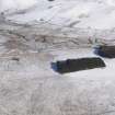
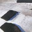
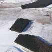
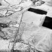
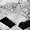
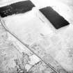
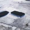
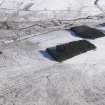
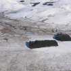
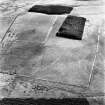
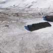
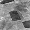
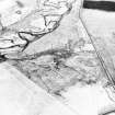
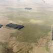
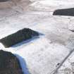
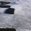
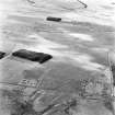
Camp B: lies within the SE portion of A (NT71SE 5.01), and utilised A's defences on the S and E sides. That the small camp is the later of the two is clear from the fact that at the NE and SW corners its ditch cuts across the line of the rampart of Camp A. Rectangular on plan, it measures 960' by 410' internally. The N and W sides are in good order, the rampart and ditch being similar in size and construction to those of the larger camp. The original number of gates was presumably six, but only four now remain and one of these, in the E side, has lost its traverse: the arrangement of the gates suggests that in this case the camp faced S. Three of the gates average 28' in width, and to judge by its traverse the northward gate in the W side was originally of similar dimensions; but it has subsequently been reduced to a width of 6'. This reduction, for which a parallel occurs at Reycross, may represent a re-occupation of the camp in Roman times.
RCAHMS 1956, visited 1949
Centred NT 755 139. The remains of Camps 'A' and 'B' have been fully described above. As stated, the earthworks within and without the SW angle are later works: two sheepfolds and an old turf (? field) bank.
Visited by OS (JLD) 11 August 1960
Generally as described by previous authorities.
Visited by OS (RD) 30 May 1968.
No change to the previous information.
Visited by OS (BS) 8 September 1976.
Publication Account (17 December 2011)
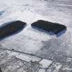
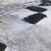
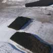
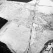
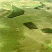
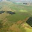
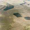
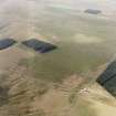
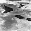
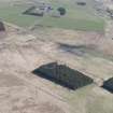
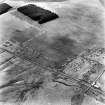
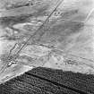
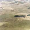
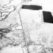
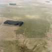
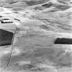
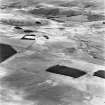
The three, possibly four, camps at Pennymuir lie on rough moorland in the Cheviot Hill beside Dere Street, close to its descent from Woden Law and on the north bank of the Kale Water. All four are recorded as earthworks in rough moorland, with camps I and II amongst the best preserved in Scotland. These two were first recorded in 1774 by William Roy (1793: Pl. XXII), with camp II occupying the south-east corner of camp I. The larger camp measures 520m from NNW to SSE by 343m transversely and enclosed almost 18ha (44 acres). Entrance gaps protected by tituli are visible on all four sides, with two on the WSW side, and the camp probably had six gates in total. The upstanding rampart of the camp measures up to 4.6m wide and 1.2m high, with the ditch some 4.6m wide and up to 1.2m deep in places.
Camp II, which utilises part of the ESE and SSE sides of camp I, measures 299m from NNW to SSE by 129m, enclosing 3.9ha (9.7 acres). Its defences are of similar dimensions to camp I. Entrance gaps protected by tituli are visible on the WSW (two) and NNW sides, and the camp also probably had six in total. Detailed field survey by RCAHMS noted that the more northerly of the two gates in the south-west side had been narrowed, which they argued might represent a reoccupation of the camp in Roman times (1956: 376).
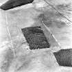
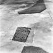
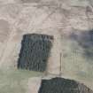
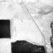
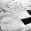
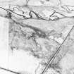
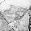
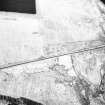
Camp III is situated just to the north-east of camps I and II , on the east side of Dere Street and, although recorded as an earthwork, has been partially obliterated by drainage and a plantation. It was recorded during scrutiny of RAF air photographs by RCAHMS in 1947 (Taylor 1948: 83; RCAHMS 1956: 375–7). It is a parallelogram in form, measuring 279 from north-west to south-east by 186m, and enclosed 5.1ha (almost 13 acres). The rampart survives in places as a low mound, some 2m wide and 0.2m high. Drainage ditches observed in 1949 showed that the ditch was about 1m wide and up to 0.5m deep, while the rampart was 2.1m wide and 0.3m high (RCAHMS 1956: 375–7). Entrance gaps with tituli are visible in the northwest and south-west sides. A section was cut through the titulus on the south-west side in 1949 (by Sir W. Aitchison – RCAHMS 1956: 377) but no further information is available.
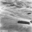
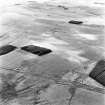
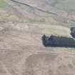
A probable fourth camp at Pennymuir was located during the study of the RAF air photographs (RCA HMS 1956: 375–7) lying on the east side of Dere Street across from camps I and II . Only part of the camp has been recorded, measuring 192m from NNW to SSE by at least 120m, suggesting that at least 2.3ha (5.6 acres) was enclosed. The rampart is visible as a low spread mound, recorded in 1949 as measuring 4m wide and 0.3m high, with a ditch 3m wide and 0.3m deep outside (RCAHMS 1956, 377). Cultivation remains and drainage ditches cut through the camp, and RCAHMS used this evidence and the dimensions of its perimeter defences to argue for a Roman date (1956: 377).
R H Jones.
Sbc Note
Visibility: This is an upstanding earthwork or monument.
Information from Scottish Borders Council

