
Floors Castle


Pond (19th Century)
Site Name Floors Castle
Classification Pond (19th Century)
Alternative Name(s) Floors Castle Policies
Canmore ID 83701
Site Number NT63SE 38
NGR NT 69750 33890
Datum OSGB36 - NGR
Permalink http://canmore.org.uk/site/83701


- Council Scottish Borders, The
- Parish Kelso
- Former Region Borders
- Former District Roxburgh
- Former County Roxburghshire
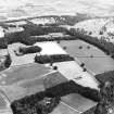
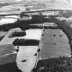
An octagonal pond some 30m in extent occupies the summit of a low eminence to the south-west of Floors Castle.
It was evidently built between 1870 and the early twentieth century, when the 2nd edition of the Ordnance Survey 6-inch map of Roxburghshire map was published.
As well as functioning as a reservoir, the pond also served as a feature in the designed landscape associated with Floors Castle.
Text prepared by RCAHMS as part of the Accessing Scotland's Past project
NT63SE 38 6975 3388
For Floors Castle (NT 71110 34670) and associated buildings, see NT73SW 5.00.
Sbc Note (15 April 2016)
Visibility: Standing structure or monument.
Information from Scottish Borders Council

