
Mid Bracco


Archaeological Landscape (Medieval) - (Post Medieval)
Site Name Mid Bracco
Classification Archaeological Landscape (Medieval) - (Post Medieval)
Canmore ID 83272
Site Number NS86NW 15
NGR NS 833 655
NGR Description Centred NS 833 655
Datum OSGB36 - NGR
Permalink http://canmore.org.uk/site/83272


- Council North Lanarkshire
- Parish Shotts (Monklands)
- Former Region Strathclyde
- Former District Monklands
- Former County Lanarkshire
Field Visit (31 May 1991)
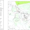
NS86NW 15.00 centred 833 655
NS86NW 15.01 Centred NS 831 657 Farmstead (CSW 4350, 4675)
NS86NW 15.02 Centred NS 834 655 Building; Huts; Enclosures (CSW 4623, 4673, 4674)
NS86NW 15.03 Centred NS 831 658 Field-system
For hut-circles and rig centred around NS 828 657, see NS86NW 16.
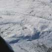
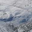
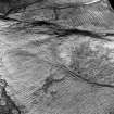
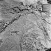
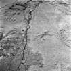
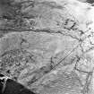
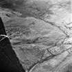
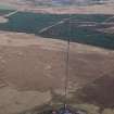
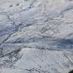
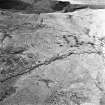
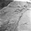
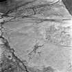
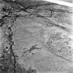
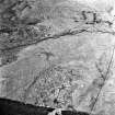
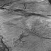
Situated on the N flank of Black Hill, there are the remains of Mid Bracco farm, which comprise two buildings, at least four huts, a number of enclosures and an extensive area of rig-and-furrow cultivation. The core of the farm is a stone-built farmhouse (NS86NW 15.01) around which the cultivation remains and enclosures lie. To the SE of this steading there is what may be a second farmstead (NS86NW 15.02) consisting of a turf-walled building surrounded by turf-walled enclosures. The field-system (NS86NW 15.03) around the farmsteads appears to belong to at least three phases of use.
From 1710-15 to 1795 Mid Bracco was divided between two tenants, but was held by only one in 1801 (Devine 1994). The two buildings probably mark the locations of the 18th century steadings, with the stone-walled farmhouse replacing an earlier turf building when the farm became a single tenancy. The stone-walled building had fallen out of use by the date of the 1st edition of the OS 6-inch map (Lanarkshire, 1859, sheet ix).
Visited by RCAHMS (DCC) 31 May 1991
Management (2001)
Scheduled as Mid Bracco, deserted farmstead, turf-walled building, huts, enclosures and field system of pre-Improvement date.
Information from Historic Scotland, scheduling document dated 13 February 2001.
Field Visit (9 November 2004 - 21 February 2008)
Headland Archaeology Ltd undertook a Cultural Heritage Assessment of the predicted impacts of the proposed windfarm on cultural heritage features.
A targeted walk-over survey was undertaken (9 November 2004 and 21 February 2008) in order to verify the findings of the desk-based assessment and to identify any previously unrecorded sites within the construction footprint of the scheme. Sites were visted as necessary in order to gather data regarding their setting.
There are two designated cultural heritage features within the inner study area. These comprise Mid Bracco deserted farmstead and Mid Bracco hut circles. The latter lies entirely within the inner study area, whilst the greater part of Mid Bracco deserted farmstead lies outside to the south-east.
Potential construction and operational impacts upon cultural heritage features have been considered and assessed. It has been concluded that, following the implementation of a programme of archaeological works, there will be no significant effects in terms of the EIA (Scotland) regulations 1999. Residual effects will be of minor or lesser significance.
Information from Headland Archaeology Ltd

