
Jura, Ardmenish, An Dunan


Fort (Later Prehistoric)
Site Name Jura, Ardmenish, An Dunan
Classification Fort (Later Prehistoric)
Canmore ID 83073
Site Number NR57SE 4
NGR NR 57850 73050
Datum OSGB36 - NGR
Permalink http://canmore.org.uk/site/83073


- Council Argyll And Bute
- Parish Jura
- Former Region Strathclyde
- Former District Argyll And Bute
- Former County Argyll
NR57SE 4 5785 7305
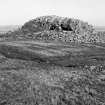
(NR 5785 7305) Fort, An Dunan: Traces of dry-stone walling enclose the 45m by 20m summit of a rock 20m high. The remains are most substantial at the NE end where there are also two ruinous outer lines of walling.
M C Jarvis 1974.
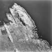
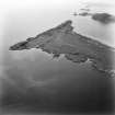
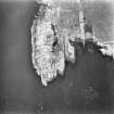
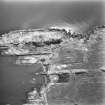
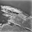
On the summit of a headland, protected on all but the north-east side by steep rock faces, are the fragmentary remains of a stone-walled fort, oval on plan. Most of the wall material has collapsed over the cliff, but a few outer facing stones survive indicating overall dimensions of about 30.5m NE-SW by 22.0m transversely. Only in the NE arc does any rubble core remain, spread to 4.5m wide and up to 0.1m internal height; here at the only reasonable approach to the fort, the position of the entrance is marked by a lintel slab in situ, 2.1m long. Within the fort, adjacent to the wall in the north arc, is a curving stretch of masonry protruding through the turf two courses high for a length of 3.0m. It may be the remains of a contemporary cell-like structure. Protecting the entrance of the fort in the north-east arc are two conjoined outer courts at lower levels. The inner court is 15.0m NW-SE by 7.5m transversely within a rubble wall whose outer face of large blocks is visible intermittently. The east side of an entrance is visible to a height of two courses; here the wall is 22.0m wide. The outer court is less clearly defined, the defence apparently comprising a discontinuous rubble wall with large outer facing stones connecting large isolated rocks. It appears to be sub-divided by another wall of similar construction.
Extending down the slope in a north-westerly direction from a large rock at the east extremity of the outer court, is a crude wall faced with unusually large rocks (of which there are large quantities eroded from the cliffs above) with the usual rubble core. This wall ceases about 8.0m from a low sea cliff about 3.0m high at the tide line along the west side of the headland. Above the cliff are further vague traces of a wall becoming more evident towards the south end of the cliff, at which point the wall turns sharply south-east to the base of the cliff protecting the fort, thereby forming an outermost court or "bailey" some 8.0m below the fort. It is entered on the south-west side adjacent to a sub-circular dry-stone cell 0.9m high and 6.0m internal diameter. Within the "bailey" is a sub-rectangular construction of large haphazardly placed blocks measuring 21.0m by 5.0m and 0.9m high, with its north end open. The crudity of the construction precludesits being the remains of a building, and one possible explanation is that it is a boat-noust of uncertain association, though it does now lie some 50.0m from the present beach level.
The relatonship between the fort with its outworks and the "bailey" is unclear; it is an unusual arrangement and may indicate re-use of the site as a defence.
A further wall crossing the isthmus may be associated; it appears to have a sub-oval slab-lined cell, 6.0m by 4.0m, built against its inner face.
Surveyed at 1/10,000.
Visited by OS (N K B) 11 May 1978.
Field Visit (May 1976)
NR578 730. This fort, with its complex of outworks and later structures, occupies the NE tip of the rocky ridge that forms the seaward end of the promontory enclosing Lowlandman's Bay, 1.2km SE of Ardmenish. The ridge runs NE and SW, and cliffs provide strong natural defence on all sides except to the NE, The main wall (A on the RCAHMS plan, [RCAHMS 1984]) stands on the highest part of the ridge (20m OD), with a series of outer walls (B, C and D) ranged on descending levels to the NE, and with further outworks (E and F) cutting off the approach to a level terrace at its foot on the W.
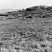
Wall A encloses a subrectangular area measuring about 25m by 20m; except on the N, it has been severely denuded, but intermittent stretches of outer facing-stones survive, standing at best to a height of 0.4m in three courses on the SE, and the amount of core material suggests that the wall may have been up to 4m thick. The entrance is on the N, where there is a gap in the wall-debris; a large slab now lying across the passage on the line of the outer face appears to be a fallen jamb-stone and not a threshold, as its present position might suggest. Within the interior, a small circular building lies in the N angle of the fort wall; it measures about 4m by 3m internally, the inner face standing to a height of about 0.5m in seven courses. Without excavation it is not possible to tell whether this little enclosure is contemporary with the fort or not. At the SW end of the interior of the fort there is a modern marker-cairn (a on RCAHMS plan).
Outside wall A to the NW, a detached stretch of walling, 1.7m long and 0.6m high in two ragged courses, blocks the SE end of a gully in the rocky massif. The principal series of outer walls, however, is situated NW, N and NE of wall A. The first of these, wall B, springs from the cliff on the E and follows the outer edge of a terrace some 5m below the level of the summit almost to the rock face on the N. Here a small path, which runs up to the terrace, is protected by a wall, now surviving only as a low band of rubble on the flank of the ridge and a series of outer facing-stones disposed at right angles to it. The entrance-passage through wall B is some 2.3m wide, with the SE side-wall still standing to a height of 0.2m in two courses; here the wall is 2.2m thick. The entrance is unusual not only in its width but also in the sheer drop of some 2m immediately outside it, and to be of practical use it must have been provided with a wooden stairway; a series of stones running across the outer line of the entrance-passage appears to be of comparatively recent date and is not shown on the plan. Immediately inside wall B, on the E portion of the terrace, the position of an enclosure or garden plot, also of no great age, is indicated by a dashed line.
Walls C and D form the sides of an elongated approach-route up the NE flank of the ridge, which is broken and rock-strewn; it is noticeable how these walls link outcrops of bare rock and cut off gullies and more accessible terraces. Wall C, on the seaward side, springs from the cliff below wall B and curves round to run down the slope towards the level ground on the N, and ends some 12m from the low cliff that forms the NW side of the promontory; its absence here may be the result of stone-robbing to provide material for a recent storehouse situated a little to the N. Wall C is constructed of large blocks (some of them measuring up to 1.05m by 0.4m and 0.35m in thickness) and the outer face still stands to a height of 1m in six courses; large stones are also incorporated in the inner face of this wall but the pinnings are less well preserved.
Wall D, which borders the inner side of the entrance-way is more difficult to interpret, as it has been denuded of its stone, but it appears to run roughly parallel to its seaward partner, and at its NE end abuts a large outcrop of rock where there may have been a gateway in the approach route. The line of wall D is broken in two places, one at the foot of the terrace on which wall B stands, and the other at about its mid-point, but it is not clear which gap originally provided access to the entrance through wall B. A small fragmentary enclosure (shown as a dashed line on RCAHMS plan) has been built in more recent times to the NW of wall D.
Access to the promontory from the W is cut off by two further walls (E and F), the only approach on the E side being along the irregular rock-strewn shore. Wall E, some 2m in average thickness, runs from the bottom of the knoll below the fort to the edge of a rocky shelf, standing some 2.5m above the shore, and is built on a foundation of large stones with particularly massive blocks forming the sides of the entrance-passage. The wall of a circular stone-built cell merges with wall E on the W but, as it impedes access from the entrance into the interior, it is presumably of later date than the main occupation of the fort. It is possible that wall ran along the crest of the low cliff to the NE but only one short stretch, to the N of a recent rectangular building, now survives to suggest this. Wall F survives as a band of rubble with a few stretches of both inner and outer facing-stones still visible, indicating a thickness of not more than about 1.5m. The wide gap in it probably marks the site of the original entrance. This wall shows neither the massive structure nor the quality of masonry of any of the others, and is probably a later addition. Two even later enclosures, indicated by dashed lines on the plan, overlie the wall and incorporate some of its stones.
On the level terrace to the NW of the main knoll there is an elongated rectangular structure. The side-walls are built
upon two natural ribs of rock and comprise a single thickness of massive boulders and slabs, many of them set on edge. The SE side-wall is the only one to retain evidence of coursed masonry; there is no trace of a NE end-wall and the structure may have been designed as a boat-shelter, although the adjacent inlet has not been levelled to facilitate landing. A small building located SE of the same inlet was evidently an equipment-store associated with the use of the boat-landing in recent times. Between these two buildings there is a small hollow or well (b on RCAHMS plan) and a cleared plot or enclosure (indicated by a dashed line).
It is possible that this fort was occupied over a long period, although without excavation any suggested sequence is conjectural. Walls A and B may be interpreted as a small defensive site of the later first millennium BC or early first millennium AD. The complex approach-route formed by walls C and D can be compared to that at Dunadd (Mid Argyll), and, together with wall E, could represent refortification during the mid-first millennium AD; it is also possible that wall F may have been added at this stage. Probably more recent still are the enclosures or huts abutting walls A and E, the less well-preserved examples beside walls B, D and F, the elongated rectangular structure and the
storehouse.
RCAHMS 1984, visited May 1976
Measured Survey (1976)
RCAHMS surveyed the fort at An Dunan using plane-table and alidade at a scale of 1:400. The resultant plan was redrawn in ink and published at a reduced scale (RCAHMS 1984, fig. 74A).
Note (8 October 2014 - 23 May 2016)
A complex series walls variously enclose the summit of this promontory and a lower terrace on the NW, and cut off the landward approach from the W, As such it may represent several separate periods and schemes of defence. At its core are the remains of the small enclosure on the summit, which measures no more than 25m from NNE to SSW by 20m transversely (0.05ha) within a denuded wall reduced to little more than a thin band of rubble with occasional outer-facing stones. Two outer walls extend along the lips of lower terraces stepping down on the NE flank, the lower swinging round to the W, possibly to utilise the leading edge of another terrace at the foot of the NW flank of the promontory before returning to the foot of the cliff forming the W side of the summit; as such it forms an annexe enclosing a further 0.19ha. The entrance to the innermost enclosure approaches through the annexe and up the NE flank of the summit, where an additional length of wall has been inserted parallel to the annexe wall to create a walled entrance way some 22m in length, though if this is what was intended it is unclear how access to the the entrance through the middle wall was gained. Entrance from the exterior into the annexe was via gap in the wall on the W, where there is also a gap in a slighter outer wall which cuts off access to the whole promontory on the landward side. Two structures are built into the innermost wall and the annexe wall respectively, in the case of the latter impeding the use of the entrance into the annexe on the W, are probably the result of later occupation; In addition there are a series of other later pens and huts, including a long rectangular structure in the annexe that the RCAHMS investigators speculated was a boat shelter.
Information from An Atlas of Hillforts of Great Britain and Ireland – 23 May 2016. Atlas of Hillforts SC2185

