
Balantrath


Broch (Iron Age)
Site Name Balantrath
Classification Broch (Iron Age)
Canmore ID 8218
Site Number ND13SW 6
NGR ND 1439 3072
Datum OSGB36 - NGR
Permalink http://canmore.org.uk/site/8218


- Council Highland
- Parish Latheron
- Former Region Highland
- Former District Caithness
- Former County Caithness
ND13SW 6 1439 3072.
(ND 1439 3072) Broch (NR)
OS 6" map, (1962)
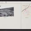
Situated on a rock on the left bank of the Dunbeath Water, just opposite the debouchment of the Achorn Burn, are the ruins of a broch. As far as can be ascertained, the diameter over all has been some 60ft. The greatest elevation, which is on the side distant from the river, is 9 or 10ft. On this side a trench appears to have been cut, isolating the portion of the rock on which the broch stands from the bank in rear of it.
RCAHMS 1911, visited 1910.
All that remains of this broch is a large mound of earth and stone situated on the edge of a short vertical cliff. The mound measures approximately 23.0m NW-SE by 15.0m transversely and is some 3.0m high; a low mound of earth and stone (0.4m high) protrudes SW from the broch mound for a distance of about 10m. There is a considerable amount of loose stone on the top of the mound, and a stretch of the outer wall of the broch, about 2.0m long and 0.8m high, is exposed. Traces of the ditch can be seen on the NE and SE sides.
Visited by OS (W D J) 27 June 1960.
As described above. Surveyed at 1:2500.
Visited by OS (R L) 14 March 1968.
The remains of a broch are generally as described by the previous authorities except that there is little loose stone now to be seen. The protruding mound noted on the SW is the side of an old quarry hollow.
Visited by OS (J M) 26 August 1982.
Publication Account (2007)
ND13 2 BALLENTRATH (‘Balan-trath’, 'Dunbeath Water')
ND/1439 3072
Probable broch in Latheron, Caith-ness, in the shape of a quarried mound standing on a rock on the left bank of the Dunbeath Water, just opposite the junction with the Achorn Burn. A stretch of curved outer wallface about 2.0m long is exposed at one point and the greatest height of the mound, away from the river, is 2.75-3.05m (9-10 ft) [1]. Traces of the ditch have been reported on the north-east and south-east sides but Swanson says that there is nothing to be seen [3]. There a few courses of what may be an outer wall are showing on the north-west and again on the west-south-west [3]. The appearance of the site is of a broch mound on top of an artificial platform [3]. Swanson’s plan shows no significant masonry apart from the wallface.
Sources: 1. NMRS site no. ND 13 SW 6: 2. RCAHMS 1911b, 58, no. 213: 3. Swanson (ms) 1985, 697-99 and plan.
E W MacKie 2007

