
Dunsiston Colliery


Building (19th Century), Colliery (19th Century), Miners Row (19th Century)
Site Name Dunsiston Colliery
Classification Building (19th Century), Colliery (19th Century), Miners Row (19th Century)
Alternative Name(s) Dunyston
Canmore ID 82169
Site Number NS86SW 20
NGR NS 8023 6445
NGR Description Centred NS 8023 6445
Datum OSGB36 - NGR
Permalink http://canmore.org.uk/site/82169


- Council North Lanarkshire
- Parish Shotts (Monklands)
- Former Region Strathclyde
- Former District Monklands
- Former County Lanarkshire
Field Visit (4 August 1992)
NS86SW 20 centred 8023 6445
A rubbish-filled hollow, lying within a partially removed bing, may mark the site of the pit-head of Dunsiston Colliery (Pit No. 2). A brick-and-concrete built building lies to the W of the pit-head, while the base of a winding mechanism is situated on the SE. A ramp runs from the WSW of the pit-head to the line of the dismantled railway which runs past the N side of the bing. The mine (CSW 4050) is depicted on the 2nd edition of the OS 6-inch map (Lanarkshire 1899, sheet viii) and is also shown on the revised edition of the same map (Lanarkshire 1913, sheet viii, resurveyed in 1910) (the spelling changes to Dunyston). Both the 2nd edition and the revision also show an airshaft 400m to the ESE at NS 8062 6438, of which nothing is now visible.
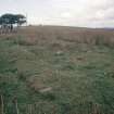
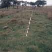
A miners row (CSW 4299) is situated beside the Roughrigg Road, at NS 8023 6445, to the NNW of the mine. It measures 61.6m from NE to SW by 6m over a robber trench about 0.2m in depth. Fragments of grass-grown brick-footings survive at the SW end, which has been partly planted with conifers. Two terraces to the SE may have been garden plots. The row is shown as roofed on both the 2nd edition map and the revision of 1910 (ibid).
Along the Roughrigg Road, to the E of the miners row and to the N of the mine at NS 8025 6463, there are the partly-robbed footings of a stone-built building (CSW 4300), measuring 30.5m from ENE to WSW by 4.9m transversely overall and about 0.2m in height. The 1st edition of the OS 6-inch map (Lanarkshire 1859, sheet viii) depicts a roofless, unnamed building and an enclosure at this location.
(CSW 4050, 4299-4300)
Visited by RCAHMS (DCC) 4 August 1992

