
Geldie Lodge


Hunting Lodge (19th Century), Stable (19th Century)
Site Name Geldie Lodge
Classification Hunting Lodge (19th Century), Stable (19th Century)
Alternative Name(s) Mar Lodge Estate
Canmore ID 81426
Site Number NN98NE 1
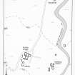
NGR NN 9548 8672
Datum OSGB36 - NGR
Permalink http://canmore.org.uk/site/81426


- Council Aberdeenshire
- Parish Crathie And Braemar
- Former Region Grampian
- Former District Kincardine And Deeside
- Former County Aberdeenshire
Field Visit (4 May 1993)
NN98NE 1.01 9548 8672
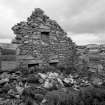
The ruins of a shooting-lodge and its stables occupy a piece of levelled ground on top of a low rise to the W of the Allt Coire an t-Seilich. The Lodge dates from the later 19th century but was subsequently considerably modified before partially collapsing in recent times.
Originally the lodge comprised a three-celled, two-storey building with an E facing entrance set between two windows, which measured 11.2m from N to S by 4.5m tranversely within mortared rubble walls, still standing to a height of 2.6m. There are fireplaces in both gables and secondary entrances have been knocked through the S end-wall and through a window-opening in the W wall. In the second phase, a wing was added to the S of the building, of which only the E half survives. Subsequently two further wings were added, on the E and W of the original lodge, both incorporating dressed granite quoins, characteristic of other lodges on the estate. In the N wall of the E wing there is an external doorway and a bay window, with a hearth on the E. The W wing was divided into two compartments, each with a fireplace. In the final phase, a passage was added in the return between the W and (by now partially demolished) S wing. Footings visible to the S of the building may indicate the presence of an outshot, built against the S wing, which suggests that the wing was at least 14m in length.
Set on a rise to the S of the lodge there is a stable-block, the N end of which has collapsed. It measures 12.3m from NNE to SSW by 5.5m transversely over rubble-faced walls 0.6m thick and standing up to 1.8m high with an entrance on the ESE. The N end has post-holes for stable partitions and rows of stones set upon edge on the floor as if to support a timber floor; the S end was lit by a window.
The 1st edition of the OS 6-inch map (Aberdeenshire 1869, sheet xcvi) shows three roofed buildings at the site: a building on a N-S axis and a smaller building about 10m to the SSW. The other building lies about 80m to the E and may be one of the buildings described with the shielings (NN98NE 1.03). The 2nd edition of the OS 6-inch map shows a group of small buildings to the W of the Lodge (Aberdeenshire 1903, sheet xcvi), of which no trace could be found, probably due to the construction of the track past the Lodge in recent times; it also depicts the lodge with a wing on its S end as well as the two wings on the N end.
(MAR93 162-3)
Visited by RCAHMS (PJD) 4 May 1993
Measured Survey (4 May 1993)
RCAHMS surveyed Geldie Lodge on 4 May 1993 at a scale of 1:100. The resultant plan was redrawn in ink and published at a scale of 1:200 (RCAHMS 1995b, Fig. 33).
Field Visit (4 May 1993)
NN98NE 1.00 9548 8672
On the W side of the Allt Coire an t-Seilich are the ruins of Geldie Lodge and its outbuildings, a sheepfold, several shieling-huts, a building-stance and two pens.
NN 9547 8671 1.01 Shooting-lodge; Stables (MAR93 162-3)
NN 9556 8689 1.02 Sheepfold (MAR93 161)
NN 9555 8668 1.03 Shieling-huts; Building-stance; Pens (MAR93 155-160)
(MAR93 155-163)
Visited by RCAHMS (PJD) 4 May 1993
Field Visit (2001)
NO 0963 8993 (Mar Lodge) Archaeological recording was undertaken in November 2000 of five structures within the Mar Lodge Estate: Geldie and Bynack Lodges, Ruigh nan Clach, Luibeg and the Porter's Lodge. The latter two sites were the only roofed structures included in the survey, the former three being roofless and ruinous. One aim of the survey of the ruined structures was to record their present condition prior to stabilisation works to prevent their further decline. The roofed buildings are to be renovated and reused, and were recorded 'as is'.
The archaeological recording identified the multi-phase nature of the buildings, and with the aid of documentary evidence, a phased account of each structure was offered.
Report to be lodged with Aberdeenshire SMR and the NMRS.
Sponsor: National Trust for Scotland.
A Dunn, D Connolly and G Ewart 2001

