
Dun Beath


Broch (Iron Age)
Site Name Dun Beath
Classification Broch (Iron Age)
Alternative Name(s) Dunbeath
Canmore ID 8133
Site Number ND13SE 17
NGR ND 15536 30447
Datum OSGB36 - NGR
Permalink http://canmore.org.uk/site/8133


- Council Highland
- Parish Latheron
- Former Region Highland
- Former District Caithness
- Former County Caithness
ND13SE 17 15536 30447
(ND 1553 3044) Dun Beath (NAT)
Broch (NR)
OS 1:10,000 1979.
Dun Beath
Broch [NAT]
OS (GIS) MasterMap, April 2010.
Field Visit (28 July 1910)
Broch, Dunbeath
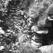
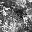
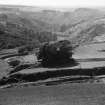
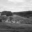
Situated at the eastern point of the watershed between the Dunbeath Water and the Burn of Houstry are the remains of the broch of Dunbeath. The broch, which was excavated many years ago by Mr Thomson Sinclair, younger of Dunbeath, and briefly described by Dr Joseph Anderson in Archaeological Scotica, is now enclosed within a walled enclosure, and the trees which have grown up around it as well as in the interior court, are not beneficial for its preservation. The entrance is from the SE through a passage 14 ft [4.3m] in length and 3ft 6ins [1.1m] in width at its outer extremity. At 3 ft 10 ins inwards, the passage expands to 4 ft, checks being thus formed on either side for a door, and 5 ft 6 ins beyond on the right hand side a slab set edgewise to the passage wall appears to mark the position of a second door. Between these door checks on the right has been the entrance to a guard chamber now broken down. The back wall of the chamber is, however, still standing at 14 ft in from the side of the passage. The dimensions of this chamber when excavated are said to have been: length 12ft 6in, width 6ft 6in, and height to the highest point of the converging sides 13ft. A small portion of the roofing remains at the back 6ft above the floor level. The internal diameter of the broch is 27 ft [8.2m]. The entrance to and position of the stair are not now recognisable. Slightly N of a point directly opposite the main entrance is an entrance 2 ft 4 ins wide, 2 ft 4 ins long and now 3 ft 3 ins high, giving access to an oblong and almost rectangular chamber measuring 8 ft in length, 6 ft in greatest width and 10 ft 2 ins in height from the present floor level to the apex of the roof. In the S wall 3ft 5in above the floor level is a small aumbry 1ft 5in in height, 1ft 2in in breadth, and 1ft in depth; in the N wall at the same level is another measuring 1ft 6in x 1.8ft x 9in; and in the wall opposite the entrance a third exactly 10in square. For the full length of the N wall at the level of the base of the aumbry runs a shelf 10in in breadth, now partially broken off. The chamber is entire except for a slight break in the wall in the angle to the right of the entrance.
The greatest height of wall visible in the interior is 13 ft, and, except for about one-third of the circumference to the left of the main entrance, there is an average elevation of from 10ft to 12ft all round. The thickness of the wall as shown by the length of the entrance passage is 14ft. At a height of about 6 ft 4 ins in the interior, there is a scarcement about 1 ft in width. The greatest height of wall visible on the exterior is 9 ft.
There was found on excavation on the S side of the interior a pit-like structure resembling a well, 4 or 5 ft in diameter.
The relics recovered consisted of deer horns; a section of an antler about 1 in long, chipped and ground at both ends; bones of the ox, of a large dog, or, possibly, of a wolf, of sheep, and swine. There were also numbers of fish bones and shells of edible molluscs; a piece of freestone thickly covered with indentations that had been produced by rubbing or grinding some kind of metal instrument edgewise upon it; several nodules of iron ore mixed with the animal remains, as also an iron 'spear-head' 5 ins in length. Close to the wall and on the clay bottom was discovered a quantity of burnt grain, viz. barley and oats.
See Archaeologica Scotica, v, pt.i, p.144; Mem. Anthrop. Soc. Lond., iii, 238.
RCAHMS 1911, visited 28 July 1910
OS 6" map
Photographic Record (1963)
Field Visit (5 March 1968)
ND13SE 17 1553 3044
Dun Beath: A broch as described by the RCAHMS. There are vague footings of outbuildings to the SE.
Resurveyed at 1:2500.
Visited by OS (NKB), 5 March 1968.
Field Visit (11 November 1982)
ND13SE 17 1553 3044
No change to the RCAHMS report. The entrance to the chamber in the back wall of the broch has been crudely blocked off. There is no sign of outbuildings as such in the SE, but there is the vague track of an old wall.
Visited by OS (JM), 11 November 1982.
Conservation (1990)
This broch was consolidated in order to make the structure safe for the general public and to prevent any further damage to the site from trees growing in the middle of the broch. The inner face of the wall was reduced and decayed stone removed, the corbelled roof of the main intramural cell was rebuilt because of the dangerous Victorian rebuild and the entranceway was defined more clearly.
During the consolidation several new features were revealed: a small niche was uncovered within the entrance passage, presumed to be part of the door structure; an alcove was revealed in the W wall, apparently not part of a staircase or passage, but remained unexcavated because of the presence of burnt bone and charcoal; an area of presumed collapsed wall was shown to be the spoilheap from the 1866 excavation. Plans and a full photographic record were made of the site. Copies of these have been lodged with NMRS, HBM and the Dunbeath Preservation Trust.
I Banks 1990.
Publication Account (1995)
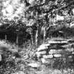
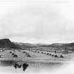
Just before the broch is reached, the path crosses a minor burn on a small suspension bridge with iron columns cast at the Ness Iron Works, Inverness. Leave the path and climb a grassy slope to find the broch on a knoll overlooking the Dunbeath Water, set in a grove of trees surrounded by a modern wall. The broch was excavated in 1866 but then decayed until in 1990 it was cleared out and consolidated.
The wall is only a metre or so high at the entrance, but rises to some 4m at the far side. A small chamber opens from the entrance passage between two sets of door checks, and a wooden draw-bar for one door may have been operated from here. On the far side of the broch there is an entrance to a larger chamber opening out either side of the door. The way such chambers were roofed can be well seen, the sides being gradually corbelled in until the remaining space could be bridged with slabs (which often formed the floor of the gallery above). There is also a scarcement ledge to support a wooden floor some 2m up. These are the only features to survive, and the staircase to the wallhead must have been reached by an opening in the wall above ground level, as at Rhiroy (no. 86) and Yarrows (no. 105). Steps would have led up to the opening. Much of the stone from this broch and any outworks has been robbed for later walls and buildings in the strath.
Beyond the broch the path continues up a most attractive wooded strath. A leaflet from Dunbeath Heritage Centre (off the A 9, on the old road southeast of the new bridge; exhibition and audiovisual programme) describes a trail along the strath through hazel, birch, rowan and bird-cherry woodland, passing various archaeological sites. Out and back, this trail is some 13km (8 miles) long and would take most of a day; at the end the trail leaves the path and involves a scramble up a hill. At the far end, there are two round chambered cairns and a long horned cairn at Loedebest, and a standing stone and a stone quarry where such slabs may have been obtained on Cnoc na Maranaich, all of which can be reached more easily by a back road from Dunbeath.
A siege of Dunbeath in AD 680 is recorded in the Annals of Ulster. The broch would then have been a collapsed mound of stones. The most likely place for an important 7th-century settlement is the headland occupied by Dunbeath Castle (which can just be glimpsed from the A 9); its situation may be compared with dark-age sites at Burghead (Moray) and Castle Rock, Dunottar (Kincardine).
Information from ‘Exploring Scotland’s Heritage: The Highlands’, (1995).
Publication Account (2007)
ND13 6 DUNBEATH ND/1553 3044 (visited 22/7/63, July 1971, 10/7/85 and 4/8/2002).
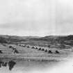
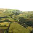
Poorly excavated and partly restored probable solid-based broch in Latheron, Caithness, standing at the edge of flat ground which falls away on two sides of the site as terraces with some vertical rock faces. On the south side there is a cliff below which runs the Dunbeath Water, and on the east a less precipitous slope descends to the Burn of Shoustry. The interior of the broch was cleared of debris in 1866 by W S T Sinclair of Dunbeath who communicated the results to Joseph Anderson in a letter [2]. The site was subsequently surrounded by a wall, and trees grow within the cleared interior; no doubt any external buildings within this wall were cleared away though skilled excavation might still reveal some traces. Further clearance and restoration took place in. The site is in an attractive setting and well worth a visit; it is reached by a half-mile walk from the main road along the Dunbeath Water.
There are traces of what may be an outer wall a short distance south-east of the broch but excavation would be needed to establish or disprove contemporaneity with the broch.
Description
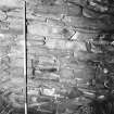
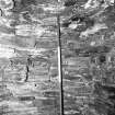
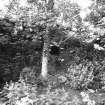
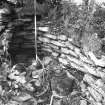
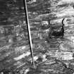
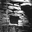
The entrance, on the south-east, is in a badly broken down section of wall and stands only about 8 courses high; it is 4.27m (14ft) long and 1.07m (3ft 6in) wide at the exterior. At a distance of 1.17m (3ft 10in) from the outside the passage widens to 1.2m (4ft) where there are built checks for a door-frame; only the left hand one is now visible. At a distance of 2.85m (9ft 4in) from the outside a slab projecting from the right wall was once visible [3] and seems to have marked the position of a second door-frame. Between the two door-frames a guard cell opens off the right wall, but the doorway to it is now wrecked (Illus. 7.0. The length of the cell was given as 3.81m (12ft 6in) and the width as 1.98m (6ft 6 in), and its back wall is 4.27m (14ft) from the passage. In plan it is an elongated oval and it curves round sharply towards the interior wallface. In 1871 its corbelled interior wallface was said to stand 4.0m (13ft) in height, but it is now much less than that (Illus. 7.00). Many water-worn sandstone slabs, presumably brought up from the river, are in this part of the wall.
The position of the doorway to the intra-mural stair – if it existed – cannot now be traced and neither can the stair itself. This, and the absence of any visible traces of an intra-mural gallery on the turfed-over wallhead, means that the site can be classed only as a probable broch, although there can be little doubt as to its true nature. Indeed, judging from the fact that the inner wallface rises about 1.5m above the scarcement (below), there may well be an upper gallery well preserved in the southern arc of the wall. Why the stair and its doorway were not found during the excavations when the entire inner wallface should have been exposed is a puzzle. It seems likely to have been in the 7-9 o’clock sector where the wall is badly broken down (as well as being damaged by the surrounding wall).
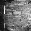
The wall on the north-west arc still stands up to 3.97m (13ft) high and the battered exterior face in this arc is impressive, standing up to 2.7m (9ft) high. On the inner face is a turfed-over ledge scarcement some 30cm wide and 1.93m (6ft 4in) above the present floor level.
At 12.30 o'clock is the lintelled, intact doorway to a rectangular mural cell; it measures 99cm (3ft 3in) high, 71cm (2ft 4in) wide and the same in depth. The near- rectangular corbelled cell itself is almost complete apart from the roof and, before the 1990 restorations, the latter had suffered some some crude rebuilding immediately above the doorway; it now has a complete modern roof . The cell measures 2.4m (8ft) long, 1.8m (6ft) wide and before 1990 still stood up to 3.10m (10ft 2 in). It is remarkable for the quality of its drystone masonry, the whole of the lower part of which is made of freshly quarried blocks and is far superior to that in the guard cell opposite; it resembles the interior of a Neolithic chambered tomb rather than an Iron Age broch. It is quite possible that the broch builders incorporated the intact chamber of an otherwise wrecked Neolithic tomb within their structure but very careful excavation round about would be required to test this idea.
On the south side of the central court was found a possible well dug into the floor, 1.2-1.5m (4-5ft) in diameter.
The1866 excavations
Sinclair's letter to Joseph Anderson described his excavations into a 'cairn', so he seems not to have realised at that stage that he was dealing with a broch. Nothing much apart from animal bones seems to have been recovered.
"Beginning on the south side, and clearing away the earth and loose stones, we found an oval chamber” [this was the guard chamber leading off the entrance passage] “with a portion of the converging roof, or dome, remaining, twelve feet six inches long, six feet six inches wide, and about thirteen feet to the highest part of the converging sides. In this preliminary experiment, I obtained the bones of various animals, among which are horns of the deer, bones of a bird, and of the cod and haddock; fragments of various kinds of jaws, the enamel of the teeth retaining its pristine freshness, although the bone bears evidence to the lengthened period of its inhumation. Along with these, the horny portion of two right hoofs of a deer, pared down upon the upper edge; a section of an antler an inch long, chipped and ground at both ends; a rib reduced by grinding to an edge; and several bones sawn across, or fractured by a blow, are indisputable traces of its former occupation by man; while at the further end, a shell heap of whelks and limpets adjoined a few small pieces of wood charcoal, above which the marks of fire were plainly visible. ... The further search for vestiges of man's handicraft did not reveal the finds of implements, etc., which I had expected on first breaking open the cairn; but on the other hand, a varied collection of bones of carnivora and herbivora. There appears to be but one trace of the human form divine, – a single vertebra of an adult, while jaws and teeth of many of the lower animals abound. Among these, there appear to me to be teeth of the ox, deer, wolf (?), boar, and stoat, with fragments of fish bones. Among this second lot was a piece of freestone, covered with numerous indentations, all nearly of the same size. One of these passes right through the stone; possibly it was used for grinding some kind of weapon. . . . The effect of intense heat is discernible on the east side of the inclosure, in the reddened and dis-integrated stones on that part of the wall. This appears to have been occasioned by a smelting fire, employed for the reduction of iron ore, several nodules of which were mixed up with animal remains, and as if in proof of the supposition, an iron spearhead, five inches long, lay beside the lumps of reduced iron in that place. Further evidence of the occupation by man is adduced by the discovery of burnt grain, bere, and oats, of which I obtained a handful close to the wall, and next to the clay bottom" [5, 238-40].
Recent work
A notice now at the site says that in 1990 some consolidation work was done on the stonework and this has been described in some detail [7]. No re-excavation was undertaken of the central court, which still contains grassed-over rubble, presumably that fallen in after the 19th century clearance. Neither was any clearing and consolidation of the wallhead done (though this would surely have exposed the upper gallery and perhaps the mural stair), nor were the young trees inside the central court removed. The recent, rebuilt, corbelled roof of the mural cell at 12.30 o'clock was removed and replaced, and extensive patching and repair of the inner wallface was done. A possible opening in the “west side of the wall” was found but not further investigated.
One interesting discovery made by the consolidator was that the core of the stonework contained quantities of earth which, it was suggested, had been used to bed down the stones. Normally brochs are assumed to be of drystone construction so the immediate conclusion might be that the external sandstone blocks had weathered and that sandy soil had thus drifted down between the stones. However midden material, including bone fragments, was found so, since this can hardly have found its way in to the wall core accidentally, it does appear that padding of the stonework was employed during the construction of this broch.
The restoration of the inner wallface above the mural cell at 1 o'clock, and of the corbelled dome of the cell itself, deserves comment. The wallface has been built up as a blank façade for about 3ft above the scarcement, which runs over the cell doorway, slightly above its lintel. Nearly every well preserved internal broch doorway shows at least one void, and usually a series of them, above the doorway lintel – the obvious purpose being to stop the huge weight of the high wall from pressing down directly on to the lintel. It could therefore be argued that the present restoration gives an impression of broch architecture which is not in keeping with modern knowledge of these structures.
On the other hand it does seem that the level scarcement is slightly lower than the lintel of the cell doorway, whereas this lintel is often incorporated into the ledge. Therefore there were probably a few courses of masonry on top of this lintel. However one would expect a weight-relieving void, or a series of them, a short distance higher up unless the structure (like Crosskirk – ND07 2) was never much higher than it is now. The midden material found in the wallface may perhaps indicate this.
Discussion
Dunbeath is one of the more notorious examples of a broch cleared out in the early days of this branch of archaeology and from which almost no useful information has been recovered. The fact that hardly any artifacts were found may not be the fault of the excavator. However the continuing absence of any more useful information after the consolidation and clearance work in 1990 is noteworthy. We still know nothing of the condition of the primary floor level, nothing of the state of the wallhead (whether there are traces of an upper gallery for example, or whether Dunbeath is a ‘low broch’ like Crosskirk) and nothing about the location of the stair (which may possibly have started at first floor level). There is therefore nothing more to be said about this site except that such a well preserved and easily accessible broch deserves a systematic new excavation with specific research goals. In addition to the outstanding problems just mentioned, the possibility that there was a Neolithic chambered cairn on the site is intriguing and ought to be investigated further.
Finds
Sinclair’s finds in the 19th century [3] include a supposed iron spearhead 13cm (5in) long and several pieces of iron ore; a piece of antler about 2.4cm (1in) long chipped and ground at both ends, 1 whetstone, a number of animal bones of ox, dog or wolf, and pig, fish bones and a sample of charred grain (bere and oats) at the foot of the wall.
Dimensions
The internal diameter of the broch was recorded as 8.24m (27ft) [3] and two measurements in 1963 gave totals of 8.24m and 8.39m (27ft 0in. and 27ft 6 in). A careful survey of the interior in 1971 showed that this was set out very close to an exact circle with a radius of 4.24m +/- 0.05m (that is a diameter of 8.48m).
There is an important Early Christian monastic site at Ballachly on the north bank of the river a short distance east of the broch [4, 123 ff.]; the most prominent feature is a high wall [6, pl. V].
Sources: 1. NMRS site no. ND 13 SE 17: 2. Anderson 1890, 144-46: 3. RCAHMS 1911b, 58-9 , no. 215: 4. Macdonald and Laing 1968: 5. Anderson 1869: 6. Morrison 1996, 47-53 and fig. 15 and pl. III: 7. Banks 1999: 8. Swanson (ms) 1985, 703-06 and plan: 9. Batey 2002, 188: 10. Close-Brooks 1995, 26, 56, 148, 165: Cowley 1999, 73.
E W MacKie 2007
Laser Scanning (2 May 2016 - 3 May 2016)
ND 15536 30447 A structural survey was carried out, 2–3 May 2016, of Dunbeath Broch. The broch was originally discovered and excavated in the 19th century, and was repaired and consolidated in 1990. In the decades since that work was carried out, several areas of the monument have become unstable and are in need of intervention. The structural reassessment identified areas of particular archaeological significance and those areas in need of further stabilisation works. A 3D laser scan survey was carried out to provide a baseline record of the monument, and a series of recommendations were made regarding the ongoing
monitoring, management and promotion of the broch as one of Caithness’ key heritage assets.
Archive: NRHE (intended)
Funder: Dunbeath Community Council and Historic Environment Scotland
Graeme Cavers and Gemma Hudson – AOC Archaeology Group
(Source: DES, Volume 17)
Excavation (20 August 2018 - 29 August 2018)
ND 1553 3044 A programme of structural conservation and excavation was undertaken, 20 – 29 August 2018, by Dunbeath and Berriedale Community Council and AOC. Conservation work comprised: the consolidation of the southern arc of the broch; the inner broch at the guard cell along with the guard cell corbelling; and reinstatement of stone that had slipped outwards on the upper course of the outer broch wall.
Limited excavations were also carried out within the centre of the broch to investigate the nature of the archaeological deposits and the extent of Victorian excavations. A trench excavated in front of the entrance to cell 2 aimed to clarify if this was a primary or secondary feature. The guard cell on the right-hand side of the entrance passage was also cleared of vegetation and rubble, which consisted of backfill from excavations in the 1990s and subsequent accumulation. In order to consolidate the southern arc of the broch, a possible cell entrance was also investigated.
Archive: NRHE (intended)
Funder: Dunbeath and Berriedale Community Council
Jamie Humble – AOC Archaeology Group
(Source: DES Volume 19)

