
Tiantulloch


Broch (Iron Age)(Possible)
Site Name Tiantulloch
Classification Broch (Iron Age)(Possible)
Canmore ID 8113
Site Number ND13NE 2
NGR ND 1524 3522
Datum OSGB36 - NGR
Permalink http://canmore.org.uk/site/8113


- Council Highland
- Parish Latheron
- Former Region Highland
- Former District Caithness
- Former County Caithness
ND13NE 2 1524 3522.
(ND 1524 3522) Broch (NR) (remains of)
(Undated) OS map annotation.
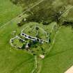
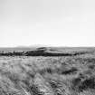
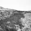
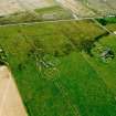
The remains of this broch, behind the croft house of Tiantulloch, are covered by a mound, 10ft high, in the E side of which appears a considerable length of broch walling, 5ft high. The overall diameter of the broch appears to have been about 56ft although part of the W side of the mound has been removed. Towards the NE is evidence of outbuildings and an exposed wall, a few feet high, bounds the site on the S.
RCAHMS 1911.
Generally as described by the RCAHM. A small semicircular alcove, of later date, has been inserted in the broch wall to the SE.
Resurveyed at 1:2500.
Visited by OS (R L) 9 May 1967.
The remains of a broch, generally as described by the RCAHMS and the previous field investigator. The broch mound rises from a larger mound containing outbuildings; this latter mound is faced on its S side and around to the NE by walling up to 1.3m high which abuts the SW end on the outside of the broch. Removal of some stone near the broch end of the wall has revealed the corbelled roof of an outbuilding and an apparent lintelled passage or gallery leading off it.
Visited by OS (J M) 8 November 1982.
Publication Account (2007)
ND13 13 TIANTULLOCH ND/1524 3522
Probable broch in Latheron, Caith-ness, consisting of a grass-covered mound 3m (10ft) high with a length of curved outer wallface on the south-east standing 1.5m (5ft) high. In the south-south-east is a cell which seems to have been built into the outer face [3]. The overall diameter is about 17.1m (56ft) and “substantial revetments” about 1.0m in height abut the outer face on the east and south-west [3]; these are composed of large blocks of stone, similar to those in the broch stonework and a lintelled entrance can be seen in the eastern one, close to the broch wall [3]. The broch mound seems to rise from a larger mound containing outbuildings on the north-east [1]; an exposed wall bounds the site on the south
Sources: 1. NMRS site no. ND 13 NE 2: 2. RCAHMS 1911b, 52, no. 196: 3. Swanson (ms) 1985, 684-86 and plan.
E W MacKie 2007

