
Fraserburgh Airfield, Tershinty Camp, Domestic Site


Air Raid Shelter(S) (Second World War), Military Camp (20th Century)
Site Name Fraserburgh Airfield, Tershinty Camp, Domestic Site
Classification Air Raid Shelter(S) (Second World War), Military Camp (20th Century)
Alternative Name(s) Inevrallochy Airfield
Canmore ID 80728
Site Number NK06SW 29
NGR NK 02641 64292
NGR Description Centred NK 02641 64292
Datum OSGB36 - NGR
Permalink http://canmore.org.uk/site/80728

- Council Aberdeenshire
- Parish Rathen
- Former Region Grampian
- Former District Banff And Buchan
- Former County Aberdeenshire
NK06SW 29 centred 02641 64292
See also Fraserburgh Airfield, NK06SW 26.00 and for other military camp, NK06SW 30.
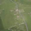
Hut footings of camp, probably associated with disused World War II airfield. Visible on air photographs AAS/93/15/G32/6-12, flown 11 November 1993. Copies in Grampian Region SMR.
NMRS MS/712/6.
(Name cited as Tershinty and location as NK 0259 6432). Hut footings of camp: probably associated with nearby airfield (NK06SW 26).
NMRS, MS/2059.
Field Visit (27 November 1996)
NK06SW 29 centred 02641 64292
A pre-afforestation survey of two small areas of land in the vicinity of Fraserburgh airfield was undertaken by Headland Archaeology (NMRS MS 899/35) in November 1996. No surface traces of the RAF camp associated with the airfield survive above ground level, in what is now arable land, although the the locations of the anti-blast shelters had been depicted on the 1:2500 OS map (1975) and the approximate positions of the former buildings are visible on vertical aerial photographs (106G/Scot/Uk108, frames 4004-5, 23 May 1946).
S Carter and C Russell-White (Headland Archaeology) 27 November 1996; NMRS MS 899/35
Note (26 January 2021)
A former RAF airfield domestic camp on the S side of the B9033 road, with at least ten blast shelters and one Stanton Shelter are depicted on a digital OS 1:10000 map. The SE part of the camp has been reclaimed for farming and no remains are visible on orthorectified 25cm aerial photography.
The Pillbox Study Group recorded from OS 1:2500 map (1965) at least 7 blast shelters at NK 0293 6407, NK 0293 6410, NK 0298 6408, NK 0297 6412, NK 0286 6410, NK 0290 6417 and NK 0264 6427. In addition a Stanton type air raid shelter was recorded at NK 0269 6429.
Information from Pillbox Study Group and HES (AKK) 26 January 2021

