
Banff, Quayside, Banff Harbour


Harbour (Period Unassigned)
Site Name Banff, Quayside, Banff Harbour
Classification Harbour (Period Unassigned)
Alternative Name(s) Banff Bay; Moray Firth
Canmore ID 80695
Site Number NJ66SE 49
NGR NJ 68883 64581
NGR Description Centred NJ 68883 64581
Datum OSGB36 - NGR
Permalink http://canmore.org.uk/site/80695


- Council Aberdeenshire
- Parish Banff
- Former Region Grampian
- Former District Banff And Buchan
- Former County Banffshire
NJ66SE 49.00 centred 68883 64581
Harbour [NAT]
OS (GIS) MasterMap, July 2011.
NJ66SE 49.01 NJ 69021 64639 North Pier, Beacon
NJ66SE 49.02 NJ 6893 6444 Pillbox
NJ66SE 49.03 NJ 69023 64640 to NJ c. 68908 64685 North Pier
NJ66SE 49.04 NJ 68994 64633 to NJ c. 68939 64447 South Pier (East Pier)
ARCHITECT: Thomas Telford, 1803-1821.
(Undated) information in NMRS.
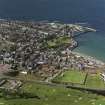
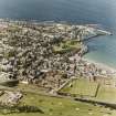
(Location cited as NJ 689 648). Banff Harbour. A large basin formed by an L-plan pier and a straight pier, and subdivided by two straight piers into three basins. The piers are all rubble-built, with much of the masonry vertically set. Now badly silted. The inner harbour was built in 1775 and the outer pier added in 1816 by engineer Thomas Telford.
J R Hume 1977.
Banff is essentially the river-mouth port of the Deveron, and is marked by Pont in one of his MS surveys as well as by Adair, Blaeu and Roy. Its earlier history, like that of Macduff, seems to have been largely influenced by the behaviour of the currents in the estuary, the shifts and vagaries of which bedevilled the navigable channels. A tradition existed that the river originally debouched on the E side of the estuary, beside the Craig of Downe, but that changes in the course of the channel and the formation of awkward sandbanks called for the construction of the harbour in some better position, and that a fresh start was accordingly made at Banff itself, on the W side of the water. With this may be compared a record attribuable to the 17th century, which states that Banff was a small and unimportant place lacking a harbour (importuosus) and that the inhabitants were consequently unequal to sea-faring business; while the Latin expression used (defecta portu) though a solecism on any showing, may possibly suggest not so much the mere lack of a port as the loss of one which had existed at some former time. The 'lost' harbour could then be thought of as the one on the old channel and not really Banff at all. The statement in the Statistical Account that 'of old' craft had entered the estuary and lain 'where the bulwark now is' does not help to clarify the question.
The same authority states that an early attempt at construction W of the river was made in 1625, that the work was continually subjected to delays and misfortunes, and was only finished in 1775, but that by the date of writing (1798) 'a most useful and commodious harbour' existed. Eight brigantines and fourteen sloops were then owned in the burgh, and a considerable trade was carried on. This was, however, by no means the whole of the story, as already in 1613 application had been made to the Convention of Royal Burghs for 'support to the helpe of thair kirk and herberie', and a grant of one hundred pounds had been made in 1615. In 1727, again, a voluntary contribution for the building of the harbour was recommended. Parliament, likewise approached, went no further than to authorise, in 1696, a public subscription in all kirks; but by this time, perhaps as the result of the delays and set-backs just mentioned, eyes were again being turned towards the Downe site, and in 1698 a grant of 500 marks towards its development was obtained, as has been noted under Macduff (NJ76SW 17). It was evidently hoped that construction on the E bank would increase the force of the current and discourage the piling-up of alluvial sand which, in 1701, was 'like to render the existing harbour useless'. Defoe's continuator noted in 1769 that Banff had two small harbours, but that large vessels could not come near them; and this suggests that both the eastern and western harbours were functioning at the same time though neither in a satisfactory way.
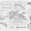
At the beginning of the 19th century, the problem was evidently tackled with considerable vigour, but the precise course of events is difficult to reconstruct as the authorities differ as to dates and points of detail, and positive criteria are lacking. According to the Harbous report, however, the existing arrangements had grown up, through a series of makeshifts, to meet the drawbacks of shallow water, invading alluvial sand, and exposure to NE gales; they comprised an inner and an outer basin, opening towards the NNE and formed by a N quay and an E pier, within which were a W pier and two jetties. In 1806 enlargement was attempted by the enclosure of an inlet on the N, and in 1818 Telford planned an outer N pier to enclose a basin, but this was damaged before completion and was still insecure in 1837. It was then repaired with clamps and chain cables. In 1836 this N pier was held to be useful in preventing 'swell and agitation' in the old harbour, the latter being then regarded as the safest in the whole Moray Firth. None the less, in 1847 measures to increase its security were under discussion, including further reconstruction, dredging and the deflection of the river's outfall.
A Graham 1979.
NJ 689 646 An archaeological watching brief was undertaken in May-June 2006 on all dredging works conducted at Banff Harbour. The Middle and Inner Basins of the harbour were dredged down to natural rock. The removed sediment comprised dark blackish brown decaying organic material and sand. Modern rubbish, including plastic, tyres, rope, chain, driftwood, brick and miscellaneous iron fragments was frequent throughout. Additionally, a modern anchor was recovered during dredging. Sand from the Outer Basin beach was used to fill sandbags for the construction of a temporary dam. Once the dredging had been completed a photographic survey of the harbour walls was made and a laser scan survey was conducted. No archaeological features or artefacts of significance were recorded during this watching brief and no further works were required.
Archive to be deposited in NMRS.
Sponsor: Morrison Construction Services.
Vicky Oleksy, 2006.
Construction (1770 - 1775)
Enlarged to plan by John Smeaton.
Construction (1818 - 1828)
Telford prepared a plan to enclose the outer basin and modify the entrance to the harbour. In 1818 a contract for this work was undertaken by local brothers, John, James and William Smith, who, despite having to rebuild the storm-damaged new quay in 1820 before it was finished, completed their contract in 1828. The resident engineer was John Gibb.
R Paxton and J Shipway, 2007.
Reproduced from 'Civil Engineering heritage: Scotland - Highlands and Islands' with kind permission from Thomas Telford Publishers.
Photographic Survey (August 1965)
Photographic survey of buildings in Banff by the Ministry of Works/Scottish National Buildings Record in August 1965.
Watching Brief (May 2006 - June 2006)
NJ 689 646 An archaeological watching brief was undertaken in May-June 2006 on all dredging works conducted at Banff Harbour. The Middle and Inner Basins of the harbour were dredged down to natural rock. The removed sediment comprised dark blackish brown decaying organic material and sand. Modern rubbish, including plastic, tyres, rope, chain, driftwood, brick and miscellaneous iron fragments was frequent throughout. Additionally, a modern anchor was recovered during dredging. Sand from the Outer Basin beach was used to fill sandbags for the construction of a temporary dam. Once the dredging had been completed a photographic survey of the harbour walls was made and a laser scan survey was conducted. No archaeological features or artefacts of significance were recorded during this watching brief and no further works were required.
Archive to be deposited in NMRS.
Sponsor: Morrison Construction Services.
V Olesksy 2006
Publication Account (2007)
Banff Harbour
This harbour, because of its position on the western side of the estuary of the Deveron, has always been subject to silting. It has been enlarged twice and, although the layout of the entrance piers has been modified to prevent
the egress of sand, the harbour empties at low water. The quays and piers of the harbour include vertically bonded masonry and stone clamps for rubbing strakes.
The first part of the harbour is believed to have begun in ca.1625 when rocks were removed to form a natural haven. It was subsequently enlarged to a plan prepared by Smeaton in 1770. This work, which enclosed the contemporary middle basin, was completed by local labour in
1775.
As silting continued to restrict access to the harbour, Telford prepared a plan to enclose the outer basin and modify the entrance to the harbour. In 1818 a contract for this work was undertaken by local brothers, John, Jamesand William Smith, who, despite having to rebuild the storm-damaged new quay in 1820 before it was finished, completed their contract in 1828. The resident engineer was John Gibb.
By 1837 the new quay, exposed to the full force of winter gales, had been badly damaged. James Bremner repaired this damage and then ballasted the exterior wall of the quay, which had been built with a shallow slope, with masonry blocks weighing from 15–40 tons These were floated into position.
The use of the harbour is now mainly recreational with some fishing.
R Paxton and J Shipway, 2007.
Reproduced from 'Civil Engineering heritage: Scotland - Highlands and Islands' with kind permission from Thomas Telford Publishers

