 |
On-line Digital Images |
DP 151190 |
Dr Colin and Dr Paula Martin |
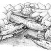
Sketch of the eroded forwardmost surviving structure excavated beneath the ballast mound. (Graham Scott) |
|
Item Level |
|
 |
On-line Digital Images |
DP 151191 |
Dr Colin and Dr Paula Martin |
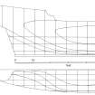
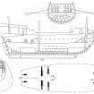
Tentative reconstruction of the Duart Point ship's lines, based on the available archaeological and other evidence. Scale in feet to accord with contemporary sources. |
|
Item Level |
|
 |
On-line Digital Images |
DP 151192 |
Dr Colin and Dr Paula Martin |
Tentative reconstruction os the Duart Point ship's profiles and internal arrangements based on the available archaeological and other evidence. Scale in feet to accord with contemporary sources. |
|
Item Level |
|
 |
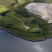
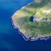
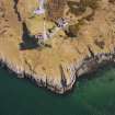
On-line Digital Images |
DP 173094 |
Dr Colin and Dr Paula Martin |
Aerial photograph of Duart Castle and Point looking west across Duart Bay at low tide. The wreck lies on the near side of the furthest point on the right. (Colin Martin) |
|
Item Level |
|
 |
On-line Digital Images |
DP 173095 |
Dr Colin and Dr Paula Martin |
Aerial photograph of Duart Castle and Point looking south-west across Duart Bay at low tide. The wreck lies on the near side of the furthest point on the right. (Colin Martin) |
|
Item Level |
|
 |
On-line Digital Images |
DP 173096 |
Dr Colin and Dr Paula Martin |
Aerial photograph of Duart Castle and Point looking west across Duart Bay at low tide. The wreck lies just off the point beyond the castle. (Colin Martin) |
|
Item Level |
|
 |
On-line Digital Images |
DP 173097 |
Dr Colin and Dr Paula Martin |
Aerial photograph of Duart Castle and Point looking west across Duart Bay at low tide. The wreck lies just off the point beyond the castle. (Colin Martin) |
|
Item Level |
|
 |
On-line Digital Images |
DP 173098 |
Dr Colin and Dr Paula Martin |
Aerial photograph of Duart Castle and Point looking south. The wreck lies just to the left of the point. |
|
Item Level |
|
 |
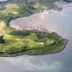
On-line Digital Images |
DP 173099 |
Dr Colin and Dr Paula Martin |
Aerial photograph of Duart Castle and Point looking south-east. The wreck lies just to the left of the point, its location indicated by the left-hand path to the rocks. (Colin Martin) |
|
Item Level |
|
 |
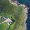
On-line Digital Images |
DP 173100 |
Dr Colin and Dr Paula Martin |
Aerial photograph of Duart Castle and Point looking north. The wreck lies just to the right of the point beyond the castle. The small sandy inlet on the far left of the picture is called Port na Birlinn—the castle’s galley harbour. (Colin Martin) |
|
Item Level |
|
 |
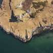
On-line Digital Images |
DP 173101 |
Dr Colin and Dr Paula Martin |
Near-vertical aerial photograph of Duart Castle and Point. The wreck lies close inshore, its position indicated by the track extending to the right, which was built to facilitate access to the working base on the rocks. (Colin Martin) |
|
Item Level |
|
 |
On-line Digital Images |
DP 173102 |
Dr Colin and Dr Paula Martin |
Near-vertical aerial photograph of Duart Castle and Point. The wreck lies close inshore, its position indicated by the track extending to the right, which was built to facilitate access to the working base on the rocks. (Colin Martin) |
|
Item Level |
|
 |
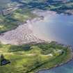
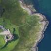
On-line Digital Images |
DP 173103 |
Dr Colin and Dr Paula Martin |
Aerial photograph of Duart Castle and Point looking south. The wreck lies to the left of the Point’s furthest extent. The small sandy inlet towards the right is called Port na Birlinn—the castle’s galley harbour. (Colin Martin) |
|
Item Level |
|
 |
On-line Digital Images |
DP 173104 |
Dr Colin and Dr Paula Martin |
Aerial photograph of Duart Castle and Point looking south. The wreck lies to the left of the Point’s furthest extent. The small sandy inlet towards the right is called Port na Birlinn—the castle’s galley harbour. (Colin Martin) |
|
Item Level |
|
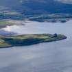 |
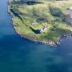
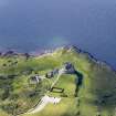
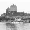
On-line Digital Images |
DP 173105 |
Dr Colin and Dr Paula Martin |
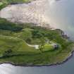
From its headland, Duart Castle dominates the south-east entrance to the Sound of Mull. The bay beyond provides shelter from most wind directions, but not from the north-west. It can therefore only be usd as a temporary anchorage. (Colin Martin) |
|
Item Level |
|
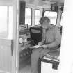 |
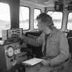
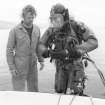
On-line Digital Images |
DP 173106 |
Dr Colin and Dr Paula Martin |
Antony Firth of the ADU keeping a dive log off Duart Point aboard the unit’s vessel Xanadu during a visit to the site in 1992.(Archaeological Diving Unit) |
1992 |
Item Level |
|
 |
On-line Digital Images |
DP 173107 |
Dr Colin and Dr Paula Martin |
Antony Firth of the Archaeological Diving Unit communicates with a diving archaeologist off Duart Point aboard the unit’s vessel Xanadu during their visit to the site in 1992. (Archaeological Diving Unit) |
1992 |
Item Level |
|
 |
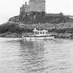
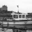
On-line Digital Images |
DP 173108 |
Dr Colin and Dr Paula Martin |
The ADU’s vessel Xanadu off Duart Point to assess the wreck on behalf of Historic Scotland in 1992. (Archaeological Diving Unit) |
1992 |
Item Level |
|
 |
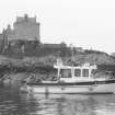
On-line Digital Images |
DP 173109 |
Dr Colin and Dr Paula Martin |
The ADU’s vessel Xanadu off Duart Point to assess the wreck on behalf of Historic Scotland in 1992. (Archaeological Diving Unit) |
1992 |
Item Level |
|
 |
On-line Digital Images |
DP 173110 |
Dr Colin and Dr Paula Martin |
The ADU’s vessel Xanadu off Duart Point to assess the wreck on behalf of Historic Scotland in 1992. (Archaeological Diving Unit) |
1992 |
Item Level |
|
 |
On-line Digital Images |
DP 173111 |
Dr Colin and Dr Paula Martin |
The ADU’s vessel Xanadu off Duart Point to assess the wreck on behalf of Historic Scotland in 1992. (Archaeological Diving Unit) |
1992 |
Item Level |
|
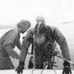 |
On-line Digital Images |
DP 173112 |
Dr Colin and Dr Paula Martin |
Antony Firth assists Ian Oxley back on board after a dive to assess the historic shipwreck off Duart Point on behalf of Historic Scotland. The assessment was carried out by the ADU, based at St Andrews University. (Archaeological Diving Unit) |
1992 |
Item Level |
|
 |
On-line Digital Images |
DP 173113 |
Dr Colin and Dr Paula Martin |
Antony Firth assists Ian Oxley back on board after a dive to assess the historic shipwreck off Duart Point on behalf of Historic Scotland. The assessment was carried out by the ADU, based at St Andrews University. (Archaeological Diving Unit) |
1992 |
Item Level |
|
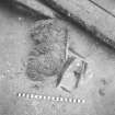 |
On-line Digital Images |
DP 173114 |
Dr Colin and Dr Paula Martin |
Organic archaeological material exposed by sea-bed erosion on the historic shipwreck off Duart Point, photographed by the ADU on behalf of Historic Scotland in 1992. The objects include a carved wooden cherub (DP92/169) from the ship’s external decoration, a staved wooden costrel (DP92/063) and a human arm bone. Timbers from the ship lie in the background. Scale in centimetres. (Archaeological Diving Unit). |
1992 |
Item Level |
|


