 |
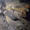
On-line Digital Images |
SC 1127028 |
Historic Scotland Archive Project |
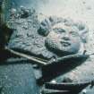
Maritime photographs: Wooden carved cherub in situ at the wreck off Duart Point during investigations by the Archaeological Diving Unit (ADU). |
1992 |
Item Level |
|
 |
On-line Digital Images |
SC 1127029 |
Historic Scotland Archive Project |
Maritime photographs: Pewter flagon (see BP 189/5/2 PO) recovered by the Archaeological Diving Unit (ADU) during investigations of the wreck off Duart Point.
|
|
Item Level |
|
 |
On-line Digital Images |
SC 1127030 |
Historic Scotland Archive Project |
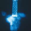
Maritime photographs: Radiograph of rapier hilt and its upper blade (Radiograph: Trustees of the National Museums of Scotland) recovered by the Archaeological Diving Unit (ADU) during investigations of the wreck off Duart Point. |
|
Item Level |
|
 |
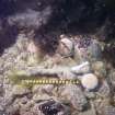
On-line Digital Images |
SC 1315122 |
Historic Scotland Archive Project |
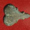
Maritime photographs: Underwater photograph of wooden carved object in situ by the Archaeological Diving Unit (ADU) during investigations of the wreck off Duart Point. |
1992 |
Item Level |
|
 |
On-line Digital Images |
SC 1316281 |
Historic Scotland Archive Project |
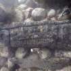
Maritime photographs: Underwater photograph showing sword concretion on seabed by the Archaeological Diving Unit (ADU) during investigations of the wreck off Duart Point. |
|
Item Level |
|
 |
On-line Digital Images |
SC 1316298 |
Historic Scotland Archive Project |
Maritime photographs: Underwater photographs of wooden objects in situ at the wreck off Duart Point during investigations by the Archaeological Diving Unit (ADU). |
|
Item Level |
|
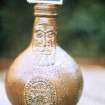 |
On-line Digital Images |
SC 1316300 |
Historic Scotland Archive Project |
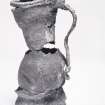
Maritime photographs: Photograph of a photograph of Frechen Bartmann Jug recovered by the Archaeological Diving Unit (ADU) during investigations of the wreck off Duart Point. |
|
Item Level |
|
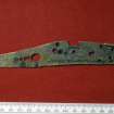 |
On-line Digital Images |
SC 1316303 |
Historic Scotland Archive Project |
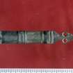
Maritime photographs: Snaphaunce pistol lock-plate recovered by the Archaeological Diving Unit (ADU) during investigations of the wreck off Duart Point. |
|
Item Level |
|
 |
On-line Digital Images |
SC 1316305 |
Historic Scotland Archive Project |
Maritime photographs: Object, possible brass fitting, recovered by the Archaeological Diving Unit (ADU) during investigations of the wreck off Duart Point.
|
|
Item Level |
|
 |
On-line Digital Images |
SC 1316307 |
Historic Scotland Archive Project |
Maritime photographs: Object, brass fitting, recovered by the Archaeological Diving Unit (ADU) during investigations of the wreck off Duart Point. |
|
Item Level |
|
 |
On-line Digital Images |
SC 1316314 |
Historic Scotland Archive Project |
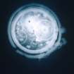
Maritime photographs: Radiograph of a fob watch recovered by the Archaeological Diving Unit (ADU) during investigations of the wreck off Duart Point.
|
|
Item Level |
|
 |
On-line Digital Images |
SC 1316316 |
Historic Scotland Archive Project |
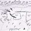
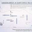
Maritime photographs: Sketch of general site plan of the wreck at Duart Point by the Archaeological Diving Unit (ADU) from the investigations of the wreck off Duart Point. |
|
Item Level |
|
 |
On-line Digital Images |
SC 1316318 |
Historic Scotland Archive Project |
Maritime photographs: 1992 site plan from the investigations of the wreck off Duart Point. |
|
Item Level |
|
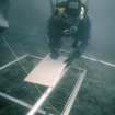 |
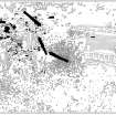
On-line Digital Images |
SC 1316320 |
Historic Scotland Archive Project |
Maritime photographs: Working photograph of a diver recording the wreck off Duart Point. |
|
Item Level |
|
 |
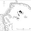
On-line Digital Images |
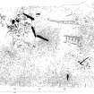
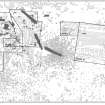
DP 151167 |
Dr Colin and Dr Paula Martin |
Duart Castle and Bay, Isle of Mull, showing depth contours in metres and the location of the Duart Point shipwreck. |
|
Item Level |
|
 |
On-line Digital Images |
DP 151168 |
Dr Colin and Dr Paula Martin |
Duart Castle and environs showing the position of the survey grid associated with the Duart Point shipwreck. |
|
Item Level |
|
 |
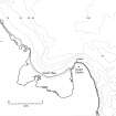
On-line Digital Images |
DP 151169 |
Dr Colin and Dr Paula Martin |
General non-intrusive site-plan of the Duart Point shipwreck, 1993. Note that the orientation has been chosen with reference to the lie of the ship, with its bow towards the right and stern towards the left. All subsequent plans of the wreck and its topography are similarly oriented. |
1993 |
Item Level |
|
 |
On-line Digital Images |
DP 151170 |
Dr Colin and Dr Paula Martin |
General non-intrusive site-plan of the Duart Point shipwreck, 1993, with three-dimensional topographical information added. Note that the orientation has been chosen with reference to the lie of the ship, with its bow towards the right and stern towards the left. Contours at 10-cm intervals record depths below the site low-water datum. |
1993 |
Item Level |
|
 |
On-line Digital Images |
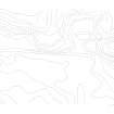
DP 151171 |
Dr Colin and Dr Paula Martin |
Contour overlay for the Duart Point wreck-site. Contours are at 10-cm intervals. See DPline004 for contour value. |
|
Item Level |
|
 |
On-line Digital Images |
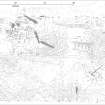
DP 151172 |
Dr Colin and Dr Paula Martin |
General plan of the Duart Point wreck-site (NM73NW 8005) at the close of excavations, 2003. Note that the orientation has been chosen with reference to the lie of the ship, with its bow towards the right and stern towards the left. |
2003 |
Item Level |
|
 |
On-line Digital Images |
DP 151173 |
Dr Colin and Dr Paula Martin |
Key to excavated areas, Duart Point shipwreck. |
|
Item Level |
|
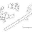 |
On-line Digital Images |
DP 151174 |
Dr Colin and Dr Paula Martin |
Plan of excavated area no.1, Duart Point shipwreck. |
|
Item Level |
|
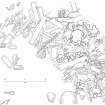 |
On-line Digital Images |
DP 151175 |
Dr Colin and Dr Paula Martin |
Plan of excavated area no.3, Duart Point shipwreck. |
|
Item Level |
|
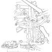 |
On-line Digital Images |
DP 151176 |
Dr Colin and Dr Paula Martin |
Plan of excavated area no.4, Duart Point shipwreck. |
|
Item Level |
|


