
Lendalfoot


Cropmark (Period Unknown), Enclosure (Period Unassigned)(Possible)
Site Name Lendalfoot
Classification Cropmark (Period Unknown), Enclosure (Period Unassigned)(Possible)
Canmore ID 80239
Site Number NX18NW 40
NGR NX 13207 89654
Datum OSGB36 - NGR
Permalink http://canmore.org.uk/site/80239


- Council South Ayrshire
- Parish Colmonell
- Former Region Strathclyde
- Former District Kyle And Carrick
- Former County Ayrshire
NX18NW 40 132 897
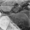
This amorphous feature has been recorded as a cropmark on oblique aerial photographs (RCAHMSAP 1992).
Information from RCAHMS (KHJM) 13 Oct 2011
Aerial Photographic Transcription (13 October 2011)

