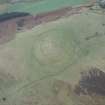
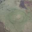
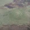
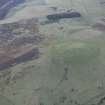
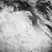
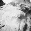
Accessibility

Font Size

100% 150% 200%

Background Colour

Default Contrast
Close Reset

Cockburn Law

Rig And Furrow (Medieval) - (18th Century)

Site Name Cockburn Law

Classification Rig And Furrow (Medieval) - (18th Century)

Canmore ID 79784

Site Number NT75NE 53

NGR NT 76411 59749

NGR Description Centre

Datum OSGB36 - NGR

Permalink http://canmore.org.uk/site/79784

Ordnance Survey licence number AC0000807262. All rights reserved.
Canmore Disclaimer. © Copyright and database right 2024.

Toggle Aerial | View on large map

Digital Images

Administrative Areas

  • Council Scottish Borders, The
  • Parish Duns
  • Former Region Borders
  • Former District Berwickshire
  • Former County Berwickshire

Archaeology Notes

NT75NE 53 centred 764 597

An area of rig-and-furrow cultivation immediately to the W of Cockburn Law fort (NT75NE 1), recorded from large scale vertical air photographs (OS 70/365/192, flown 1970.

Information from RCAHMS

Activities

Note (12 September 2019)

The location, classification and period of this site have been reviewed.

Sbc Note

Visibility: This is an upstanding earthwork or monument.

Information from Scottish Borders Council

References

MyCanmore Image Contributions


Contribute an Image

MyCanmore Text Contributions