
Dounreay Airfield


Airfield (20th Century)
Site Name Dounreay Airfield
Classification Airfield (20th Century)
Alternative Name(s) Thurso
Canmore ID 78844
Site Number NC96NE 87
NGR NC 9933 6700
NGR Description Centred NC 9933 6700
Datum OSGB36 - NGR
Permalink http://canmore.org.uk/site/78844


- Council Highland
- Parish Reay
- Former Region Highland
- Former District Caithness
- Former County Caithness
NC96NE 87.00 centred 9933 6700
NC96NE 87.01 centred NC 99460 66591 and NC 99581 66748 Cinema (possible); Building
NC96NE 87.02 NC 99719 67205 Control tower
NC96NE 87.03 NC 99510 67393 Aircraft hangar
NC96NE 87.04 centred NC 99952 67205 Military camp (falls partly on map sheet )
NC96NE 87.05 centred NC 99813 66385 Military camp
NC96NE 87.06 centred NC 99656 66065 Military camp (falls partly on map sheet )
NC96NE 87.07 centred NC 99526 66063 and NC 99178 65854 Military camp; Engine house
For (re-use as) Dounreay, nuclear research establishment (NC 98 67), see NC96NE 78.
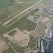
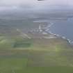
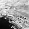
Although construction began early in 1942 this airfield was not completed until 1944. When more or less complete in April 1944, the station was occupied by a Care and Maintainance party and the runways obstructed.
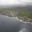
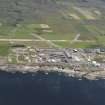
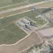
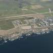
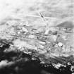
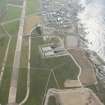
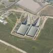
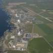
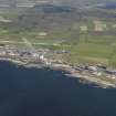
The site was later encroached upon by the construction nuclear power station (NC96NE 78). One runway was retained, the research station having been built on the northern half of the airfield. The wartime control tower has now been modernised.
D J Smith 1983.
There are a few buildings extant, on both sides of the road, although the Dounreay Nuclear Power Station has been built on part of the site.
J Guy 2000; NMRS MS 810/10, Vol.1, 7
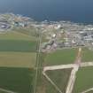
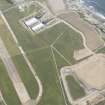
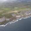
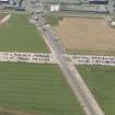
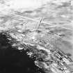
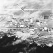
Historical aerial photography (106G/Scot/UK133, 3171-3172, flown 30 June 1946), shows that this WW II airfield was supplied with four hangars, three possible type 'T' or 'Bellman' and one blister, and an aircraft shooting butt as well as the usual airfield flying side buildings including the control tower (NC96NE 87.02. The airfield also incorporated several small accommodation and technical camp areas to the S of the A836 public Road.
Since the construction of the Nuclear Power Station most of the buildings on the airfield have been cleared. However, within the Power Station complex several wartime structures survive. Restricted oblique aerial photographs taken by RCAHMS (RCAHMS 1995) show that a hangar and part of another have been re-used, or alternatively new sheds of similar design built on the same site. In addition, the shooting butt along with some Nissen huts are also visible on the oblique photographs. Also discernable on the aerial photographs amongst the Nuclear Power Station buildings are the remains of the NW-SE runway and many of the taxiways.
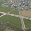
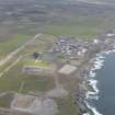
To the S of the road most of the camp areas have been cleared, though several can be found by the concrete hut bases and a few ruined brick and concrete buildings. One area (centred ND 00034 66532) still retains a few upstanding buildings and a electricity generator house and possible parachute building also survive.
Visited by RCAHMS (DE, SW, GS), August 2000
The WW II period control tower, formerly in use as a visitor centre, has now been demolished.
Information from RCAHMS (DE) November 2008

