
Islesburgh


Chambered Cairn (Neolithic)
Site Name Islesburgh
Classification Chambered Cairn (Neolithic)
Canmore ID 785
Site Number HU36NW 1
NGR HU 3346 6845
Datum OSGB36 - NGR
Permalink http://canmore.org.uk/site/785


- Council Shetland Islands
- Parish Northmavine
- Former Region Shetland Islands Area
- Former District Shetland
- Former County Shetland
HU36NW 1 3346 6845.
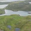
HU 334 685. A heel-shaped chambered cairn excavated by C.S.T. Calder in 1959 (C S T Calder 1965), is situated on a small promontory, on a sloping site a little above the water. It is now low and turf-covered but most of the edging of facing-stones can be seen.
The cairn measures about 16' from front to back but the actual edge at the back is indistinct. The facade at the front, facing SE across the voe is about 20' across, and has probably been somewhat under as the south tip seems to have been removed. Two of the stones have been displaced forwards; the taller stones are nearer the ends, the highest being 1'8".
There appears to be some cairn material in front of the facade which might be a deliberate blocking of the entrance. HU 3346 6847. A good example of a small, heel-shaped cairn as described and planned by Henshall.
A S Henshall 1963; C S T Calder 1956, 1958, 1965.
Publication Account (1997)
The Islesburgh tomb is tiny and perfect. An excellent example of a heel-shaped cairn, it was excavated in 1959, revealing a concave facade with the entrance to the chamber in the centre. T he tips of the facade are missing, but it must have been almost 9m across, and the cairn is almost 5m deep. A narrow passage leads into a small rectangular chamber, little more than a metre across. It is open to the sky now, but there would originally have been higher walls and a stone slab roof, with cairn material piled on top. There were no finds in the chamber.
Set on a slope, the tomb faces south-east over the sheltered voe. A short distance to the west is the site of a prehistoric house, which may well be the home of the people who built the tomb. A planticrue has been built on top of the house, but the north end of the house can still be seen. A hand quern for grinding grain lies a little to the south-east. The house is enclosed with in a substantial walled enclosure, 61m across, which runs down to finish above the shore, and a stream passes immediately west of the enclosure. The modern cairn to the west is a sea-mark for navigation.
Information from ‘Exploring Scotland’s Heritage: Shetland’, (1997).

