
Castle Pool, Cauld


Weir (Period Unassigned)
Site Name Castle Pool, Cauld
Classification Weir (Period Unassigned)
Alternative Name(s) River Teviot; King's Haugh; Springwood Policies
Canmore ID 77781
Site Number NT73SW 85
NGR NT 71334 33531
Datum OSGB36 - NGR
Permalink http://canmore.org.uk/site/77781


- Council Scottish Borders, The
- Parish Roxburgh
- Former Region Borders
- Former District Roxburgh
- Former County Roxburghshire
NT73SW 85 71334 33531
Location formerly cited as NT 7135 3355.
Cauld [NR]
OS 1:10,000 map, 1993.
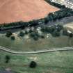
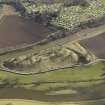
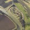
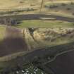
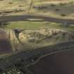
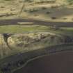
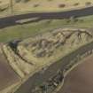
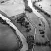
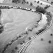
The 1993 edition of the OS 1:10,000 map depicts this structure as spanning the River Teviot diagonally between NT c. 71338 33584 and NT c. 71363 33481. The river here forms the boundary between the parishes of Roxburgh (to the W) and Kelso (to the E).
The function and purpose of this weir remain unclear. There is no watermill in clear association with it.
Information from RCAHMS (RJCM), 1 February 2006.
Sbc Note
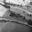
Visibility: This is an upstanding earthwork or monument.
Information from Scottish Borders Council
Sbc Note
At the west end of the site there are the remains of an old dam or cauld. There is a local tradition which claims that the purpose of the dam was to provide water to flood the castle ditch (the different water levels make this very unlikely)
Information from Scottish Borders Council Historic Environment Record
(n.d.)

