
Iona, Grianan


Field Boundary(S) (Period Unassigned)
Site Name Iona, Grianan
Classification Field Boundary(S) (Period Unassigned)
Canmore ID 77106
Site Number NM22SE 54
NGR NM 2886 2477
NGR Description NM 2886 2477 and NM 2884 2480
Datum OSGB36 - NGR
Permalink http://canmore.org.uk/site/77106

- Council Argyll And Bute
- Parish Kilfinichen And Kilvickeon
- Former Region Strathclyde
- Former District Argyll And Bute
- Former County Argyll
NM22SE 54 2886 2477 and 2884 2480
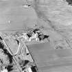
During an archaeological evaluation of a proposed pipeline route in January 1993, a series of field boundaries were noted at the foot of the raised beach between the projected route and Cladh an Diseart. Two discrete phases were indicated. The first, arching out eastward, appears relatively modern in date, the second, which arches westward up the raised beach, is ephemeral and appears to be partly denuded by the rig and furrow. (MS/725/31, GUARD 116)
Site recorded by AOC (Scotland) Ltd during an archaeological survey of the lands controlled by the National Trust for Scotland on Iona. This survey was conducted in late May and early April of 1996. The full report of this survey has been deposited with both the local SMR and the NMRS.
NM 2884 2480 Enclosure and banks
Sponsor: National Trust for Scotland
T Rees 1996
Field Visit (January 1993)
During an archaeological evaluation of a proposed pipeline route in January 1993, a series of field boundaries were noted at the foot of the raised beach between the projected route and Cladh an Diseart. Two discrete phases were indicated. The first, arching out eastward, appears relatively modern in date, the second, which arches westward up the raised beach, is ephemeral and appears to be partly denuded by the rig and furrow. (MS/725/31, GUARD 116)
Field Visit (April 1996 - May 1996)
Site recorded by AOC (Scotland) Ltd during an archaeological survey of the lands controlled by the National Trust for Scotland on Iona. This survey was conducted in late May and early April of 1996. The full report of this survey has been deposited with both the local SMR and the NMRS.
NM 2884 2480 Enclosure and banks
Sponsor: National Trust for Scotland
T Rees 1996
Field Visit (April 1996 - May 1996)
To the immediate north of Grianan lies an enclosure, 10.0m by 17.0 m, with an opening to the south. The northern end of the enclosure includes a small structure, 3.0m by 1.5 m, composed of pebble-rich walls, 0.4m high and 0.75m broad.
The enclosure is connected to a bank running away to the south which is subsequently truncated by the water interconnector onto the island.
A circular pen, 3.0m by 2.0m with walls 0.3m high lies 10.0m to the north-west of the structure.
(ION96 019)
Information from NTS (SCS) January 2016

