
Buaile Oscar, Beinn Freiceadain


Fort (Prehistoric)
Site Name Buaile Oscar, Beinn Freiceadain
Classification Fort (Prehistoric)
Canmore ID 7632
Site Number ND05NE 18
NGR ND 0594 5574
Datum OSGB36 - NGR
Permalink http://canmore.org.uk/site/7632


- Council Highland
- Parish Reay
- Former Region Highland
- Former District Caithness
- Former County Caithness
ND05NE 18 0594 5574
(ND 0594 5575) Buaile Oscar (NAT)
Fort (NR)
OS 6" map, (1963)
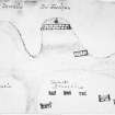
'Buaile Oscar' (Oscar's Fold) is a probable Early Iron Age fort, consisting of a single wall generally 12ft thick, but increasing to 15ft in thickness. The entrance, on the WNW, is 5ft wide and lined with large slabs.
(The chambered cairn described on ND05NE 12 lies on the summit of the hill, within this fort.)
RCAHMS 1911, visited 1910; R W Feachem 1963.
The remains of this fort are as described above.
Visited by OS (W D J), 13 April 1962.
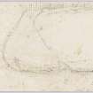
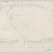
Buaile Oscar is a uni-vallate fort on the summit of Beinn Freiceadain measuring 290.0m NNW-SSE by 150.0m transversely. The wall is best destinguished in the NW where there is a simple entrance, 1.5m wide, where it is 4.0m thick and up to 1.0m high, and inner and outer facing slabs are evident.
In the N and NW the wall survives as a terrace surmounted by a slight bank, and in the S as a tenuous heathery scarp, except for a marked stretch of walling, 2.0 to 2.5m broad and up to 0.5m high, in the SE. A natural cliff forms the defence in the NE.
Visited by OS (J M), 9 July 1962.
Field Visit (21 October 1955)
This site was included within the RCAHMS Marginal Land Survey (1950-1962), an unpublished rescue project. Site descriptions, organised by county, are available to view online - see the searchable PDF in 'Digital Items'. These vary from short notes, to lengthy and full descriptions. Contemporary plane-table surveys and inked drawings, where available, can be viewed online in most cases - see 'Digital Images'. The original typecripts, notebooks and drawings can also be viewed in the RCAHMS search room.
Information from RCAHMS (GFG) 19 July 2013.
Publication Account (1995)
An extensive fort known as Buaile Oscar occupies the plateau-like summit of the hill. The steep slopes on the north and east sides had no artificial defences, but a substantial rampart, now overgrown, encloses the rest of the hill. Most unusually, this rampart is set partway down the hill, taking advantage of a slight natural terrace. In places, cliff-like exposures of flagstone immediately behind the rampart seem to have been quarried for building material, while elsewhere quarry pits have been dug to the rear. The only visible entrance is to the north-east, where one stone slab still lines the back of the rampart.
Within the fort is a grass-grown mound, the remains of a neolithic chambered cairn. On the low ground between the fort and the road there are a number of other structures, ranging from abandoned crofthouses to neolithic and bronze-age cairns; several are indicated on the OS map.
Information from ‘Exploring Scotland’s Heritage: The Highlands’, (1995).
Note (17 February 2015 - 18 May 2016)
This fort is situated on the summit of Beinn Freiceadain, the central of three summits along this ridge that dominates the moorland interior of Caithness. Oval on plan, it measures about 290m from NW to SE by 145m transversely (3.5ha) within a single wall that has probably been in the order of 2.4m in thickness, which can be traced everywhere except the NE, where a cliff-edge takes up its line. Where best preserved around the NW end the wall has been reduced to a stony scarp up to 4.5m broad and 1m high, in which the line of the outer face can be detected in places and there are a few external quarry pits at its foot. Along the steeper SW flank, however, it follows a natural terrace halfway down the slope and there is evidence of quarrying along the rock-faces to its rear. Towards the SE end the wall mounts the slope obliquely, but there are also Intermittent traces of what may be an outer defence continuing along this lower line. While there is one gap in the wall on the N, and a second in a gully midway along its SW side, the only certain entrance is on the NW, where a single massive inner facing slab has been set up on end to mark the inner angle on the E, while other slabs were set along its sides to forma passage 4.5m in length by 1.5m in width. Apart from a chambered cairn and a shepherds cairn, the interior is featureless.
Information from An Atlas of Hillforts of Great Britain and Ireland – 18 May 2016. Atlas of Hillforts SC2823

