
Canna, Coroghon Barn


Barn (18th Century), Building (Period Unassigned), Structure (Period Unassigned)
Site Name Canna, Coroghon Barn
Classification Barn (18th Century), Building (Period Unassigned), Structure (Period Unassigned)
Alternative Name(s) An Coroghon; An Coroghan; Coroghon Bay; Corroghon Tithe Barn
Canmore ID 76047
Site Number NG20NE 26
NGR NG 27846 05528
Datum OSGB36 - NGR
Permalink http://canmore.org.uk/site/76047


- Council Highland
- Parish Small Isles
- Former Region Highland
- Former District Lochaber
- Former County Inverness-shire
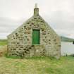
Coroghon barn, built between 1789 and 1805 Excellent survival of a bank barn, a traditional long rubble and slated range of composite function.
Taken from "Western Seaboard: An Illustrated Architectural Guide", by Mary Miers, 2008. Published by the Rutland Press http://www.rias.org.uk

NG20NE 26 27846 05528
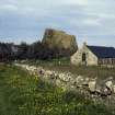
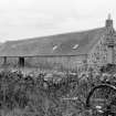
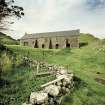
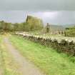
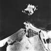
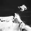
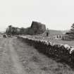
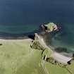
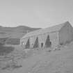
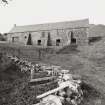
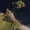
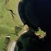
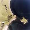
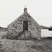
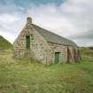
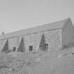
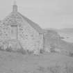
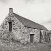
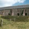
Coroghon Barn was built in the late eighteenth century and occupies a sloping site above Coroghon Bay. It is a two-storey rectangular building of random rubble construction with rubble dressings and a slated roof. The lower floor is cobbled and divided into two compartments, the larger to the SE, where there are drains running transversely from each of its three door openings. These are entered from the main SW-facing elevation, which is supported by three buttresses, presumably of later date. The upper storey is similarly subdivided and has a doorway at ground-level, located centrally on the rear NE-facing elevation, allowing access to the larger of the two compartments; this compartment has at least five slit-vents, two of which have been enlarged to form windows, and one of which is central to the SE gable. Access to the smaller compartment of the upper storey was by way of an external stair leading to a central door in the NW gable; this has a chimney stack, and a blocked fireplace is visible in the SW corner of the compartment. The barn, and a roofed building aligned from N to S to the SE, are depicted at roughly this location on an estate map of 1805, while the 1st edition of the OS 6-inch map shows four roofed buildings, two adjoining enclosures and a well (Argyllshire, 1881, sheet lx).
To the N of the NW end of the barn, the wall of a rectangular building can be seen incorporated in the line of a modern field wall (NG 2783 0550). The building lay on the N side of the modern wall, and is visible in the field as a rubble platform measuring at least 5.2m from NNE to SSW by 5.1m transversely overall. The remains of another possible building to the SSE is suggested by a further straight line joint in the modern field wall.
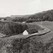
On the shore above Coroghon Bay, some 22m to the SW of the E end of the barn, a small rectangular structure abuts the S face of a plantation wall (NG 2784 0554). It has mortared rubble walls, plastered internally, and measures 1.8m from NE to SW by 1.55m transversely within a wall 0.6m in thickness and 1m in height.
(Canna 648-9)
Visited by RCAHMS (ARG), 7 April 1995.
Probably late 18th century, long rectangular barn on site sloping both to west and south. Long 2-storey west elevation; east elevation set into slope to give raised ground floor. All harl pointed random rubble with roughly dressed rubble dressings. 3 later buttresses re-enforce west elevation; 3 lower ground floor byre entrances with further (enlarged) stable entrance at NW. Centre raised ground floor winnowing door (blocked) with 2 long slit vents to right (south); further vent in centre of south gable. Long rear elevation has centre (enlarged) entrance/winnowing door with pair vents to left (opposing those in west elevation) now enlarged as windows. Centre doorway reached by forestair in north gable serving bothy/dwelling. Single apex stack at north; slate roof with pottery ridge.
Interior: internally the building is roughly divided into 2 unequal portions; centre and south 2/3rds with byre in lower ground floor and threshing floor barn in raised ground floor; north portion has slightly different floor levels, owing to slope; stable (with enlarged door) in lower ground floor and 2 room dwelling in upper floor.
Good example of Lochaber type "bank barn", a composite steading/barn built against slope. Coroghon barn site close to sheltered Coroghon Bay, possibly to facilitate sea transport of grain and beasts. (Historic Environment Scotland List Entry)
Field Visit (7 April 1995)
Coroghon Barn was built in the late eighteenth century and occupies a sloping site above Coroghon Bay. It is a two-storey rectangular building of random rubble construction with rubble dressings and a slated roof. The lower floor is cobbled and divided into two compartments, the larger to the SE, where there are drains running transversely from each of its three door openings. These are entered from the main SW-facing elevation, which is supported by three buttresses, presumably of later date. The upper storey is similarly subdivided and has a doorway at ground-level, located centrally on the rear NE-facing elevation, allowing access to the larger of the two compartments; this compartment has at least five slit-vents, two of which have been enlarged to form windows, and one of which is central to the SE gable. Access to the smaller compartment of the upper storey was by way of an external stair leading to a central door in the NW gable; this has a chimney stack, and a blocked fireplace is visible in the SW corner of the compartment. The barn, and a roofed building aligned from N to S to the SE, are depicted at roughly this location on an estate map of 1805, while the 1st edition of the OS 6-inch map shows four roofed buildings, two adjoining enclosures and a well (Argyllshire, 1881, sheet lx).
To the N of the NW end of the barn, the wall of a rectangular building can be seen incorporated in the line of a modern field wall (NG 2783 0550). The building lay on the N side of the modern wall, and is visible in the field as a rubble platform measuring at least 5.2m from NNE to SSW by 5.1m transversely overall. The remains of another possible building to the SSE is suggested by a further straight line joint in the modern field wall.
On the shore above Coroghon Bay, some 22m to the SW of the E end of the barn, a small rectangular structure abuts the S face of a plantation wall (NG 2784 0554). It has mortared rubble walls, plastered internally, and measures 1.8m from NE to SW by 1.55m transversely within a wall 0.6m in thickness and 1m in height.
(Canna 648-9)
Visited by RCAHMS (ARG), 7 April 1995.
Measured Survey (5 April 1995)
RCAHMS surveyed the farmstead at Tarbert Barn, Canna on 5 April 1995 with plane-table and alidade at a scale of 1:100. The plan and east elevation were later redrawn in ink.
Project (16 April 2015 - 23 April 2015)
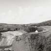
As part of on-going work by the National Trust for Scotland four sites on Canna were investigated, 16–23 April 2015, using a variety of geophysical techniques. NG 2444 0625 Beinn Tighe Souterrain A substantial grass mound encompasses a souterrain on its S flank. The mound, which lies on the crest of a rise on the E side of an old field wall, is c15m in diameter and has been extensively damaged by rabbit burrowing. The souterrain is aligned N/S
and survives in at least two sections with modern breaks providing access through the roof. The upper section is 6m long and the lower 3.8m. Internally, the souterrain varies between 0.8–1.3m in width. Its sides are rock-cut, but in places stretches of stone walling survive. The rabbit burrowing has previously uncovered many fragments of coarse pottery, but also some slag, flint, and bone. Ground Penetrating Radar (GPR) and resistance survey was carried out over the souterrain to confirm its full extent and to map any potential structures associated with it.
Although a wealth of anomalies was detected by the GPR survey, interpretation is cautious. Several coherent responses are evident within the data, but whether these are due to potentially significant in situ structures or rabbit burrows is not clear. The situation is further complicated by the fact that rabbit burrows could be utilising any possible structural remains, as was observed with the ‘walling’ of the souterrain. The resistance survey showed well defined high resistance anomalies which suggest buried stone, a more definitive interpretation is limited by the later ridge and furrow cultivation and, again, by the extensive rabbit burrows. NG 2441 0593 Beinn Tighe Neolithic Site The known Neolithic site in Beinn Tighe is a low mound, which is
overridden by lazy bed cultivation. The terrace forms part of the floor of a rocky amphitheatre, and the mound lies towards its leading edge. As an assemblage of Neolithic pottery and flint flakes had been recovered as a result of rabbit damage to the mound, the site was excavated in 2006–7 as part of a programme to assess the nature and extent of rabbit damage to archaeological structures. Two trenches were excavated across the site and produced quantities of pot sherds and some lithics. Well-stratified charcoal from the lower archaeological layer was also recovered. To better understand the extent and nature of the site a resistance survey was undertaken.
Although well defined high resistance anomalies were detected, which suggest the presence of buried stone beneath the surface, a more definitive interpretation is limited by the later ridge and furrow cultivation and the extensive rabbit burrows within the area. However, the resistance data shows good correlation with the previous excavation and test pitting results suggesting the limits of the resistance anomalies are archaeologically significant rather than simply the product of later agricultural activity.
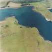
NG 2692 0553 A’ Chill, St Columba’s Chapel A’ Chill is reputedly a monastic site established by St Columba, or possibly a monastery established at the site of a Columban chapel. Nothing is now visible of the chapel and burial ground which once stood at A’ Chill although the site is marked by a finely carved Celtic Cross. Until about 1850 this was also the principal area of farming settlement on the island. The area was cleared of tenants in 1851 and little trace of the township can now be seen. The resistance survey was undertaken over a c1ha area and detected a wealth of anomalies of likely archaeological significance. The presumed chapel previously detected and evaluated by Bradford University has been detected in this survey, although it is not very well defined. However, this data set suggests possible internal and external responses associated with the main structure suggesting the potential
for a more substantial complex. One of the clearest anomalies within this data set is a rectilinear anomaly to the N of the postulated chapel and on the same alignment. Anomalies apparently associated with the outcropping rock and suggestive of the remnants of structures ‘built in’ to the outcrops have also been detected. Numerous additional linear and rectilinear anomalies have been detected throughout the survey area suggesting a potential network of field systems. In addition, anomalies thought to be associated with the culvert have also been noted. The data set is extremely complex, and it has to be remembered that geophysics cannot date features and it is possible that some apparently associated anomalies are not contemporary and the data is detecting a palimpsest of potential archaeological remains. In addition rabbit activity in the area may be creating spurious anomalies.
NG 278 056 Coroghon Township The British Fisheries map of Canna Harbour of 1788 shows nine houses above Coroghon Bay in a valley called Lag a’ Bhaile (the dell of the township) in the E of the island. The township is also shown in a sketch, probably drawn from memory by Lt Peirce in 1787. However, by the time of the Clanranald map of 1805 there is no sign of the township. It was decided in consultation with the National Trust for Scotland to undertake a limited survey of the field. Unfortunately the resistance survey failed to identify any anomalies of archaeological significance. Time permitted only limited survey in this area and it is possible the survey did not cover the area of the former township. The survey was positioned based on the 1787 sketch and it is possible, based on British Fisheries map that the survey block was too far to the E. However, it is also possible that no buried remains associated with the township survive either due to the nature of construction within the township, or because subsequent intensive ploughing has destroyed any ephemeral deposits. It is also feasible that any potential surviving remains are buried under colluvium beyond the depth resolution of the technique.
Archive: Rose Geophysical Consultants
Funder: The National Trust for Scotland
Susan Ovenden - Rose Geophysical Consultants
(Source: DES, Volume 16)
Resistivity (16 April 2015 - 23 April 2015)
NG 2444 0625
NG 2441 0593
NG 2692 0553
NG 278 056
As part of on-going work by the National Trust for Scotland, resistance surveys took place at four sites on Canna.
Archive: Rose Geophysical Consultants
Funder: The National Trust for Scotland
Susan Ovenden - Rose Geophysical Consultants
(Source: DES, Volume 16)

