
Minto Craigs


Fort (Period Unassigned)(Possible)
Site Name Minto Craigs
Classification Fort (Period Unassigned)(Possible)
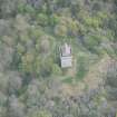
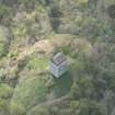
Alternative Name(s) Fatlips Castle
Canmore ID 75810
Site Number NT52SE 30
NGR NT 5816 2093
Datum OSGB36 - NGR
Permalink http://canmore.org.uk/site/75810


- Council Scottish Borders, The
- Parish Minto
- Former Region Borders
- Former District Roxburgh
- Former County Roxburghshire
NT52SE 30 5816 2093
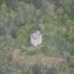
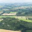
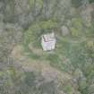
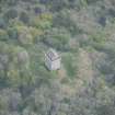
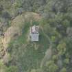
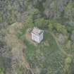
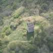
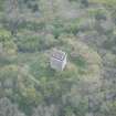
What may be the remains of a fort can be discerned under heavy vegetation within the heavily-quarried area to the NW and W of Fatlips Castle (NT52SE 10). An arc of curving rampart (measuring about 4.1m in thickness and at least 0.6m in height) appears to run roughly NE-SW for a distance of 43m along the break of a natural slope about 60m NW of the Castle, and another length of at least 27m survives in a similar situation further to the WSW. No remains can be identified on the small summit plateau, and the fort has presumably been constructed to incorporate areas of natural outcrop.
Visited by RCAHMS (RM/JRS) 29 September 1993.
Note (20 August 2015 - 18 May 2016)
What may be the rampart of a fort has been noted in the woodland some 60m NW of Fatlips Castle, a tower-house occupying the easternmost of the rocky summits of Minto Craigs. The rampart, which has been reduced to a bank 4m in thickness by 0.6m in height, can be traced from NE to SW for some 40m in a shallow arc along a natural break in slope, reappearing to the WSW for a further 27m. While evidently including the summit occupied by the tower-house, no attempt has been made to survey the full extent of the interior, but a projection of a circuit roughly following the contours and crags suggests that it might enclose as much as 0.6ha.
Information from An Atlas of Hillforts of Great Britain and Ireland – 18 May 2016. Atlas of Hillforts SC3319
Sbc Note
Visibility: This is an upstanding earthwork or monument.
Information from Scottish Borders Council

