
Castlehill House Steading


Farmstead (19th Century)
Site Name Castlehill House Steading
Classification Farmstead (19th Century)
Alternative Name(s) Castlehill
Canmore ID 75686
Site Number ND16NE 48
NGR ND 19599 68601
Datum OSGB36 - NGR
Permalink http://canmore.org.uk/site/75686


- Council Highland
- Parish Olrig
- Former Region Highland
- Former District Caithness
- Former County Caithness
ND16NE 48 19599 68601
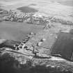
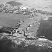
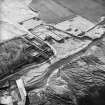
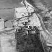
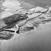
The buildings of this large farmstead comprise two steadings, together with a range of outbuildings used as stores and offices, and are associated with the working farm of Castlehill House (ND16NE 40) and the adjacent Pavement Works (ND16NE 42). Now largely roofless, the main steading is arranged as a square around a courtyard and incorporates two-storey dwellings, some with external stone stairs, carriage houses and stables with lofts above, workshops and stores, and a barn with granary above. A two-storey farmhouse and water-powered threshing barn are attached to the latter, on the NE and NW respectively. The waterwheel and pit are both still visible, originally fed by a lade made of flagstones, open as it leads into the wheel pit, but otherwise covered and underground throughout the steading. This lade took water from the Stangergill Burn, and also fed into the dam for the Pavement Works. The second steading is U-shaped on plan and lies to the SW, between the courtyard steading and the road to Castletown. It is all of single-storey height and includes byres, a lean-to piggery, turnip shed, and dairy, with a five-bay cart shed attached on the SE. In the early 1990s, the byre range and cart shed were reroofed and converted into an interpretation centre and museum for the Castlehill Flagstone Trail. The buildings are all of roughly coursed local flagstone, roofed in slate or flagstone.
Information from RCAHMS (ARG), 10 July 2006.
Former steading complex to the now demolished Castlehill House, located near to Castletown Harbour and forming part of the Castlehill Pavement Works flagstone quarry adjacent.
Formed from 2 ranges - a larger courtyard formation to the East and a smaller U plan formation to the West. The complex includes stables, a granary, byres, mill, dwellings, carriage house, and sheds, all disposed around a large open courtyard. The ranges are constructed of roughly coursed local flagstone, some roofed in slate.
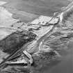
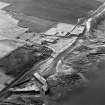
James Traill, lawyer and Sheriff-Depute of Caithness, planned Castletown from 1802 but it was not until 1825 that the associated pavement industry was fully operational. Although flagstone had been quarried earlier, it was from 1825 that the industry began to flourish, and by 1900 500 quarriers were employed at Castletown alone. Caithness flagstones were used for paving across Great Britain and exported as far as New Zealand and South America. Traill's residence, Castlehill House, was demolished following a fire in 1970. (Beaton)

