
Ousdale


Enclosure (Period Unassigned)
Site Name Ousdale
Classification Enclosure (Period Unassigned)
Alternative Name(s) Lat 310
Canmore ID 7536
Site Number ND02SE 20
NGR ND 0789 2034
Datum OSGB36 - NGR
Permalink http://canmore.org.uk/site/7536


- Council Highland
- Parish Latheron
- Former Region Highland
- Former District Caithness
- Former County Caithness
ND02SE 20 0789 2034.
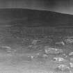
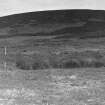
ND 0789 2034. A large, grass-covered, roughly horse-shoe shaped enclosure, 24 by 16m, with a bank about 3m wide and 1.5m in maximum height, lying adjacent to a stream and surrounded by a series of rock-strewn terraces. On the W is a possible concentric bank and ditch, apparently associated, and to the SE is a bank 8.5m long and 0.3m wide. The site, slightly truncated on the N by a field boundary, is delineated on the W by a marsh.
The amount of natural deposition is difficult to gauge.
C Batey 1982.
Except for the 'bank and ditch' on the W side, which is probably of recent costruction, all other features appear to be natural.
Visited by OS (N K B) 8 November 1982.
Project (1980 - 1982)
Field Visit (5 November 1982)
Except for the 'bank and ditch' on the W side, which is probably of recent costruction, all other features appear to be natural.
Visited by OS (N K B) 8 November 1982.
Field Visit (1982)
ND 0789 2034. A large, grass-covered, roughly horse-shoe shaped enclosure, 24 by 16m, with a bank about 3m wide and 1.5m in maximum height, lying adjacent to a stream and surrounded by a series of rock-strewn terraces. On the W is a possible concentric bank and ditch, apparently associated, and to the SE is a bank 8.5m long and 0.3m wide. The site, slightly truncated on the N by a field boundary, is delineated on the W by a marsh.
The amount of natural deposition is difficult to gauge.
C Batey 1982.

