
Littlemill


Roundhouse (Prehistoric)(Possible), Souterrain (Prehistoric)(Possible)
Site Name Littlemill
Classification Roundhouse (Prehistoric)(Possible), Souterrain (Prehistoric)(Possible)
Canmore ID 75335
Site Number NJ52SE 27
NGR NJ 5870 2491
Datum OSGB36 - NGR
Permalink http://canmore.org.uk/site/75335

- Council Aberdeenshire
- Parish Leslie (Gordon)
- Former Region Grampian
- Former District Gordon
- Former County Aberdeenshire
NJ52SE 27 5870 2491
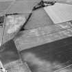
(Location cited as NJ 587 249 and name as Littlemill). On a SE-facing slope, the cropmark of a possible circular house with extension. ?house and souterrain. Discovered while checking vertical air photographs held by GRC.
Sponsors: Historic Scotland, Grampian Regional Council.
R Feilden 1991a
(Location cited as NJ 5870 2491). Littlemill. Air photography (AAS/84/02/RS/2 and AAS/84/01-2/RS/13) has recorded a solid circular cropmark with an extension (possibly representing a house and souterrain in arable ground on a gentle SE-facing slope at an altitude of 180m OD.
NMRS, MS/712/53.

