|
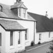
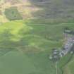
Photographs and Off-line Digital Images |
A 1961 |
List C Survey |
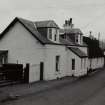
View of white-washed cottage and adjacent house. |
1975 |
Item Level |
|
|
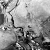
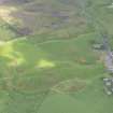
Photographs and Off-line Digital Images |
LA 1256 |
|
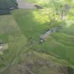
View of Braehead. |
1975 |
Item Level |
|
|
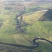
Photographs and Off-line Digital Images |
H 92178 PO |
Central Excavation Unit |
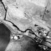
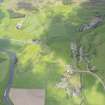
Oblique aerial view centred on the remains of the possible fort with the footbridge adjacent, taken from the ESE. |
27/2/1979 |
Item Level |
|
|
Photographs and Off-line Digital Images |
H 92179 PO |
Central Excavation Unit |
Oblique aerial view centred on the remains of the possible fort with the footbridge adjacent, taken from the SE. |
27/2/1979 |
Item Level |
|
|
Manuscripts |
MS 5156/1 |
Historic Scotland Archive Project |
Survey Archive: List of sites and associated APs from Millbank to Nether Abington, along the proposed line of the M74 motorway. |
1990 |
Item Level |
|
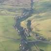 |
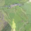
On-line Digital Images |
DP 208977 |
RCAHMS Aerial Photography Digital |
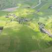
General oblique aerial view of Roberton village and the remains of the possible fort, looking NW. |
18/11/2014 |
Item Level |
|
 |
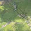
On-line Digital Images |
DP 208978 |
RCAHMS Aerial Photography Digital |
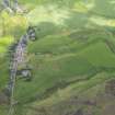
General oblique aerial view of Roberton village, the remains of the possible fort and Bower of Wandel Tower House, looking NW. |
18/11/2014 |
Item Level |
|
 |
On-line Digital Images |
SC 1648964 |
List C Survey |
View of white-washed cottage and adjacent house. |
1975 |
Item Level |
|
 |
On-line Digital Images |
SC 1727520 |
Central Excavation Unit |
Oblique aerial view centred on the remains of the possible fort with the footbridge adjacent, taken from the ESE. |
27/2/1979 |
Item Level |
|
 |
On-line Digital Images |
SC 1727521 |
Central Excavation Unit |
Oblique aerial view centred on the remains of the possible fort with the footbridge adjacent, taken from the SE. |
27/2/1979 |
Item Level |
|
 |
On-line Digital Images |
DP 307283 |
Historic Environment Scotland |
Oblique aerial view. |
18/6/2019 |
Item Level |
|
 |
On-line Digital Images |
DP 307284 |
Historic Environment Scotland |
Oblique aerial view. |
18/6/2019 |
Item Level |
|
 |
On-line Digital Images |
DP 307285 |
Historic Environment Scotland |
Oblique aerial view. |
18/6/2019 |
Item Level |
|
 |
On-line Digital Images |
DP 307286 |
Historic Environment Scotland |
Oblique aerial view. |
18/6/2019 |
Item Level |
|
 |
On-line Digital Images |
DP 307287 |
Historic Environment Scotland |
Oblique aerial view. |
18/6/2019 |
Item Level |
|
 |
On-line Digital Images |
DP 307288 |
Historic Environment Scotland |
Oblique aerial view. |
18/6/2019 |
Item Level |
|
 |
On-line Digital Images |
DP 307289 |
Historic Environment Scotland |
Oblique aerial view. |
18/6/2019 |
Item Level |
|
 |
On-line Digital Images |
DP 307290 |
Historic Environment Scotland |
Oblique aerial view. |
18/6/2019 |
Item Level |
|
 |
On-line Digital Images |
SC 2530179 |
|
View of Braehead. |
1975 |
Item Level |
|


