 |
On-line Digital Images |
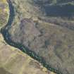
DP 080100 |
RCAHMS Aerial Photography Digital |
Oblique aerial view of the Caen Burn and the remains of the hut-circles and small cairns with the township buildings beyond, taken from the NNE. |
29/5/2009 |
Item Level |
|
 |
On-line Digital Images |
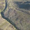
DP 080101 |
RCAHMS Aerial Photography Digital |
Oblique aerial view of the Caen Burn and the remains of the hut-circles and small cairns with the township buildings beyond, taken from the NNE. |
29/5/2009 |
Item Level |
|
 |
On-line Digital Images |
SC 2351312 |
Records of the Ordnance Survey, Southampton, Hampshire, England |
Caen Burn North, ND01NW 30, Ordnance Survey index card, page number 1, Recto |
1958 |
Item Level |
|
 |
On-line Digital Images |
SC 2552579 |
Records of the Ordnance Survey, Southampton, Hampshire, England |
Caen Burn North, ND01NW 30, Ordnance Survey index card, page number 2, Verso |
1958 |
Item Level |
|
|
All Other |
551 166/1/1 |
Records of the Ordnance Survey, Southampton, Hampshire, England |
Archaeological site card index ('495' cards) |
1947 |
Sub-Group Level |
|


