
Caen Burn North


Cairn(S) (Period Unassigned), Field Boundary(S) (Period Unassigned), Hut Circle (Prehistoric)
Site Name Caen Burn North
Classification Cairn(S) (Period Unassigned), Field Boundary(S) (Period Unassigned), Hut Circle (Prehistoric)
Alternative Name(s) Caen
Canmore ID 7446
Site Number ND01NW 30
NGR ND 0110 1860
Datum OSGB36 - NGR
Permalink http://canmore.org.uk/site/7446


- Council Highland
- Parish Kildonan
- Former Region Highland
- Former District Sutherland
- Former County Sutherland
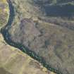
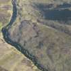
ND01NW 30 0110 1860.
(ND 010 186) Enclosures (NR) (see also ND01NW 29)
OS 6" map, (1964)
Some 100 yards NNE of the hut circle (ND01NW 6 ) there is a circular enclosure. An old wall runs off from the bank on the E of the enclosure. RCAHMS 1911, visited 1909.
The hut circle at ND 0110 1860 measures internally 11.0m SE-NW by 10m. The wall is spread to about 2.8m in the NW widening to 4.0m at the entrance in the SE. The wall running from the hut is of a questionable age; although of a slight nature for the first 40m, after an intersection with a ditch of the 18th/19th century, it continues in a form of certain 18th/19th century type (This may be a head-dyke, see ND01NW 71). Whether this second stretch overlies an earlier wall cannot be seen. The ground surrounding the three huts (ND01NW 6, ND01NW 29, ND01NW 30 ) is slightly marshy in places and borders 18th/19th century enclosures lying downhill to the E. An old field wall and one or two clearance heaps are the only traces of contemporary cultivation in the vicinity.
Revised at 1/10,000.
Visited by OS (W D J) 24 May 1976 and (J B) 15 May 1976.

