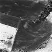
 |
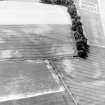
On-line Digital Images |
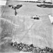
SC 347542 |
RCAHMS Aerial Photography |
Oblique aerial view. |
1992 |
Item Level |
|
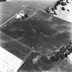
 |
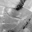
On-line Digital Images |
SC 1711562 |
RCAHMS Aerial Photography |
Oblique aerial view. |
1990 |
Item Level |
|
 |
On-line Digital Images |
SC 1711563 |
RCAHMS Aerial Photography |
Oblique aerial view. |
1990 |
Item Level |
|
 |
On-line Digital Images |
SC 1711564 |
RCAHMS Aerial Photography |
Oblique aerial view. |
1990 |
Item Level |
|
 |
On-line Digital Images |
SC 1711565 |
RCAHMS Aerial Photography |
Oblique aerial view. |
1990 |
Item Level |
|
 |
On-line Digital Images |
SC 1711582 |
RCAHMS Aerial Photography |
Oblique aerial view. |
1992 |
Item Level |
|
 |
On-line Digital Images |
SC 1711584 |
RCAHMS Aerial Photography |
Oblique aerial view. |
1992 |
Item Level |
|
 |
On-line Digital Images |
SC 1711586 |
RCAHMS Aerial Photography |
Oblique aerial view. |
1992 |
Item Level |
|
 |
On-line Digital Images |
SC 1711587 |
RCAHMS Aerial Photography |
Oblique aerial view. |
1992 |
Item Level |
|
 |
On-line Digital Images |
SC 1711588 |
RCAHMS Aerial Photography |
Oblique aerial view. |
1992 |
Item Level |
|
 |
On-line Digital Images |
SC 1711598 |
RCAHMS Aerial Photography |
Oblique aerial view. |
28/6/1994 |
Item Level |
|
 |
On-line Digital Images |
SC 1711600 |
RCAHMS Aerial Photography |
Oblique aerial view. |
28/6/1994 |
Item Level |
|
 |
On-line Digital Images |
SC 1711601 |
RCAHMS Aerial Photography |
Oblique aerial view. |
28/6/1994 |
Item Level |
|
 |
On-line Digital Images |
SC 1711602 |
RCAHMS Aerial Photography |
Oblique aerial view. |
28/6/1994 |
Item Level |
|
 |
On-line Digital Images |
SC 1711603 |
RCAHMS Aerial Photography |
Oblique aerial view. |
28/6/1994 |
Item Level |
|
 |
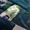
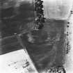
On-line Digital Images |
SC 1711688 |
|
Carpow and Gillies Burn, oblique aerial view, taken from the NE, centred on the cropmarks of a Roman Fort, a Roman enclosure and an unenclosed settlement. The cropmarks of a Roman aqueduct and a ring-ditch, and Mains of Carpow farmsteading are visible in the top half of the photograph, and linear cropmarks are shown in the bottom centre half. |
12/7/1996 |
Item Level |
|
 |
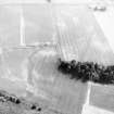
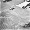
On-line Digital Images |
SC 1711689 |
|
Carpow and Gillies Burn, oblique aerial view, taken from the NNW, centred on the cropmarks of a Roman Fort, a Roman enclosure, a ring-ditch and an unenclosed settlement. Mains of Carpow farmsteading is visible in the top right-hand corner of the photograph, and linear cropmarks are shown in the bottom left-hand corner. |
12/7/1996 |
Item Level |
|


