|
Photographs and Off-line Digital Images |
RX 33 |
Records of the Royal Commission on the Ancient and Historical Monuments of Scotland (RCAHMS), Edinbu |
General view. |
c. 1948 |
Item Level |
|
|
Photographs and Off-line Digital Images |
RX 34 |
Records of the Royal Commission on the Ancient and Historical Monuments of Scotland (RCAHMS), Edinbu |
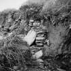
Ruined end of culvert |
c. 1948 |
Item Level |
|
|
Photographs and Off-line Digital Images |
RX 35 |
Records of the Royal Commission on the Ancient and Historical Monuments of Scotland (RCAHMS), Edinbu |
Ruined end of culvert |
c. 1948 |
Item Level |
|
|
Photographs and Off-line Digital Images |
RX 36 |
Records of the Royal Commission on the Ancient and Historical Monuments of Scotland (RCAHMS), Edinbu |
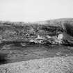
Road to Craik Cross exposed by Borthwock Water, showing remains of culvert |
c. 1948 |
Item Level |
|
 |
On-line Digital Images |
SC 1603703 |
Records of the Royal Commission on the Ancient and Historical Monuments of Scotland (RCAHMS), Edinbu |
Ruined end of culvert |
c. 1948 |
Item Level |
|
 |
On-line Digital Images |
SC 1603704 |
Records of the Royal Commission on the Ancient and Historical Monuments of Scotland (RCAHMS), Edinbu |
Road to Craik Cross exposed by Borthwock Water, showing remains of culvert |
c. 1948 |
Item Level |
|
|
All Other |
551 166/1/1 |
Records of the Ordnance Survey, Southampton, Hampshire, England |
Archaeological site card index ('495' cards) |
1947 |
Sub-Group Level |
|


