 |
On-line Digital Images |
DP 080121 |
RCAHMS Aerial Photography Digital |
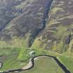
General oblique aerial view of the remains of the township buildings, rig, field systems and hut-circles, taken from the SSW. |
29/5/2009 |
Item Level |
|
 |
On-line Digital Images |
DP 080122 |
RCAHMS Aerial Photography Digital |
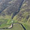
General oblique aerial view of the remains of the township buildings, rig, field systems and hut-circles, taken from the SSW. |
29/5/2009 |
Item Level |
|
 |
On-line Digital Images |
SC 1896288 |
Papers of James Sloan Bone, landscape historian, Inverness, Highland, Scotland |
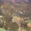
An oblique aerial view of Craig Halligarry, Strath of Kildonan, East Sutherland, looking NNE. |
1998 |
Item Level |
|
 |
On-line Digital Images |
SC 2350862 |
Records of the Ordnance Survey, Southampton, Hampshire, England |
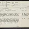
Craig Halligarry, NC92SW 25, Ordnance Survey index card, page number 1, Recto |
1958 |
Item Level |
|
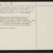 |
On-line Digital Images |
SC 2350863 |
Records of the Ordnance Survey, Southampton, Hampshire, England |
Craig Halligarry, NC92SW 25, Ordnance Survey index card, page number 2, Verso |
1958 |
Item Level |
|
|
All Other |
551 166/1/1 |
Records of the Ordnance Survey, Southampton, Hampshire, England |
Archaeological site card index ('495' cards) |
1947 |
Sub-Group Level |
|


