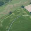
 |
On-line Digital Images |
SC 505292 |
|
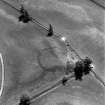
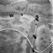
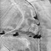
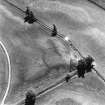
Monzie, oblique aerial view, taken from the NNW, centred on the cropmarks of a settlement and palisaded settlement. |
|
Item Level |
|
 |
On-line Digital Images |
SC 1702002 |
RCAHMS Aerial Photography |
Oblique aerial view. |
1989 |
Item Level |
|
 |
On-line Digital Images |
SC 1702003 |
RCAHMS Aerial Photography |
Oblique aerial view. |
1989 |
Item Level |
|
 |
On-line Digital Images |
SC 1702004 |
RCAHMS Aerial Photography |
Oblique aerial view. |
1989 |
Item Level |
|
 |
On-line Digital Images |
SC 1702005 |
RCAHMS Aerial Photography |
Oblique aerial view. |
1989 |
Item Level |
|
 |
On-line Digital Images |
SC 1702007 |
RCAHMS Aerial Photography |
Oblique aerial view. |
1989 |
Item Level |
|
 |
On-line Digital Images |
SC 1702012 |
RCAHMS Aerial Photography |
Oblique aerial view. |
1989 |
Item Level |
|
 |
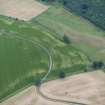
On-line Digital Images |
SC 1702027 |
RCAHMS Aerial Photography |
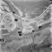
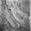
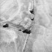
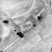
Monzie, oblique aerial view, taken from the E, centred on the cropmarks of a settlement and palisaded settlement. |
17/8/1995 |
Item Level |
|
 |
On-line Digital Images |
SC 1702066 |
RCAHMS Aerial Photography |
Monzie, oblique aerial view, taken from the NW, centred on the cropmarks of a palisaded settlement and possible square barrows. The Witches' stone is visible in the bottom left-hand corner of the photograph and cropmarks of a barrow and moated site are visible in the top half. |
12/8/1996 |
Item Level |
|
 |
On-line Digital Images |
SC 1702067 |
RCAHMS Aerial Photography |
Monzie, oblique aerial view, taken from the WNW, centred on the cropmarks of a palisaded settlement. Cropmarks of a barrow are visible in the top half of the photograph. |
12/8/1996 |
Item Level |
|
 |
On-line Digital Images |
SC 1702161 |
RCAHMS Aerial Photography |
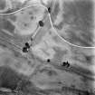
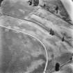
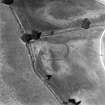
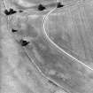
Monzie, oblique aerial view, taken from the SE, centred on the cropmarks of a settlement and palisaded settlement. |
17/8/1995 |
Item Level |
|
 |
On-line Digital Images |
SC 1702162 |
RCAHMS Aerial Photography |
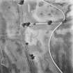
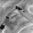
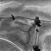
Monzie, oblique aerial view, taken from the NE, centred on the cropmarks of a settlement and palisaded settlement. |
17/8/1995 |
Item Level |
|
 |
On-line Digital Images |
SC 1702163 |
RCAHMS Aerial Photography |
Monzie, oblique aerial view, taken from the NNW, centred on the cropmarks of a settlement and palisaded settlement. |
17/8/1995 |
Item Level |
|
 |
On-line Digital Images |
SC 1702255 |
RCAHMS Aerial Photography |
Monzie, oblique aerial view, taken from the WSW, centred on the cropmarks of a palisaded settlement. Cropmarks of a barrow are visible in the top half of the photograph. |
12/8/1996 |
Item Level |
|
 |
On-line Digital Images |
SC 1702258 |
RCAHMS Aerial Photography |
Monzie, oblique aerial view, taken from the SE, centred on the cropmarks of a barrow, possible ring-ditch and moated site. Cropmarks of a palisaded settlement are visible in the top half of the photograph. |
12/8/1996 |
Item Level |
|
 |
On-line Digital Images |
DP 280190 |
Historic Environment Scotland |
Oblique aerial view. |
10/7/2018 |
Item Level |
|
 |
On-line Digital Images |
DP 280191 |
Historic Environment Scotland |
Oblique aerial view. |
10/7/2018 |
Item Level |
|
 |
On-line Digital Images |
DP 280192 |
Historic Environment Scotland |
Oblique aerial view. |
10/7/2018 |
Item Level |
|


