
Crail, Marketgate, Market Cross


Market Cross (17th Century)
Site Name Crail, Marketgate, Market Cross
Classification Market Cross (17th Century)
Alternative Name(s) Crail, Mercat Cross
Canmore ID 70944
Site Number NO60NW 13
NGR NO 61356 07828
Datum OSGB36 - NGR
Permalink http://canmore.org.uk/site/70944


- Council Fife
- Parish Crail
- Former Region Fife
- Former District North East Fife
- Former County Fife
NO60NW 13 61356 07828
For old market cross, see NO60NW 14.
(NO 6136 0783) Cross (NAT)
OS 25" map (1914)
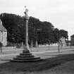
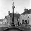
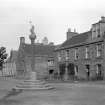
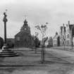
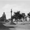
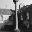
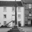
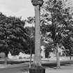
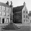
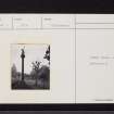
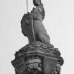
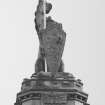
Town cross, Crail. The cross has stood since 1887 to the E of the tolbooth (NO60NW 11). Only the shaft is original. It probably dates from the early 17th century.
RCAHMS 1933
The cross of Crail, which stood in the Marketgait, was restored to its former place a few years ago.
A H Millar 1895
The market cross of Crail is said to be a restoration of the old one, the shaft only being old (for earlier cross see 60 NW 14).
J W Small 1900
This cross is as described. No further information.
Visited by OS (WDJ) 28 August 1968.
Field Visit (20 June 1927)
TOWN CROSS. The cross has stood since 1887 to the east of the tolbooth, but the only part of it that is original is the shaft, which probably dates from the early 17th century.
RCAHMS 1933, visited 20 June 1927.
Publication Account (1987)
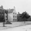
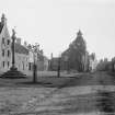
Crail is an old burgh with three medieval streets: High Street, Marketgate and Nethergate. Looking at the air photograph it can be seen that High Street and Marketgate may in the past have formed one large market stance. The Golf Hotel and surrounding buildings break the building line immediately to the west of the tolbooth. This may indicate the original boundary of the High Street or the position of former luckenbooths-an area of the market, close to the tolbooth or guard-house, where permanent stalls were erected to accommodate those merchants, such as goldsmiths, whose wares were highly priced and easily stolen.
The market cross was the symbol of the Burgh's authority and was normally situated close to the tolbooth in a prominent position in relation to the whole market area. It is hot known where the original cross stood in Crail but the present cross was re-erected in 1887 on the Marketgate site. The cross utilises a 17th century shaft with 19th century unicorn and base. The design is probably faithful to the original appearance. When considering the cross in relation to the Marketgate as a whole, one must ignore the avenue of trees that cut across this space on the line of the present road.
The Marketgate is comparable in size to the High Street and the tolbooth acts as a focal point to both streets. It sits at a rather odd angle to the present building lines. The tolbooth is a quaintly attractive building with a squat 18th century tower.
The lower part of this tower dates from the early 16th century and may have looked like a tower-house or like Dysart Tolbooth (no. 27) without its belfry. This masonry has been extended to replace part of the 18th century timber work. The 1814 'Town House' and council chamber replace a building of 1612.
The Marketgate has a number of fine townhouses of 17th and 18th century dates. Unlike their counterparts in some neighbouring burghs, many of these have been restored without resorting to the use of harl. There is a small town museum to the south of the tolbooth and the Crail Preservation Society has published a good guide to the buildings of the burgh.
Information from ‘Exploring Scotland’s Heritage: Fife and Tayside’, (1987).

